BROWSE JOURNEYS BY MAP VIEW

Saturday 30 April 2022

Tondu to Pyle and the Cefn Cribwr Ironworks


Starting Point - Tondu Station. Finishing Point - Pyle Station. Distance - 7 Miles

Below - Departing from the single platform at Tondu the Maesteg train passes the signal box and once important junction north of the station. The line coming in on the left is the route from Margam. The line has been mothballed for some years and was last used to divert trains from the mainline to Swansea and beyond due to engineering work. In more recent times a closure of the mainline would result in the trains being replaced by buses. With speed limits as low as 5 mph it is no longer practical to divert the trains this way.  


The Garw and Ogmore Valley lines once left on the right hand side of the above photo. I have covered the Garw and Ogmore Valley lines on previous posts. These lines served a number of collieries until the late 1980s and the main source of traffic for the routes in this area was moving coal from the mines to the steel works at Port Talbot.
Though there is still track on the trackbed from Tondu to Margam it is possible to follow the route part of the way on foot and cycle paths that run alongside. Having been exploring several old railways in the area on bike I cycled this route as far as Pyle, where I could catch a train on the mainline it parallels.


The path from Tondu to Pyle leaves Maesteg Road close to the Wesley Church Centre. This is actually a trackbed from another line, the tramway that connected Tondu Iron Works and a number of coke ovens.
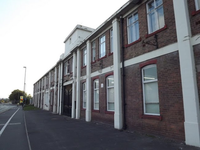
At the time of writing the extensive remains of Tondu Iron Works were fenced off and overgrown but plans were in place to incorporate them in a restaurant and hotel complex. I did visit the iron works site in 2013 and have covered it here.

On the tramway a bridge survives that carried the line over another line that linked the iron works to nearby mines.

Below - Bridge that carried the tramway over another line.


From what was once the headshunt at the end of the tramway the path curves to the south following the footpath that existed on the old map above. It emerges on Fountain Road close to the Parc Slip Visitor Centre and Bridgend Miniature Railway. 


Further south on Fountain Road the railway crosses the road by means of an un-gated crossing with flashing lights.
The path continues across Fountain Road past the Park Slip Visitor Centre veering off the roadway and heading south on what the above map shows as an Old Tramway to the site of Park Slip Colliery. This tramway doesn't appear on earlier maps so may have been short lived. The area has been heavily mined and quarried so it's hard to match features on the old maps to the landscape today.
The path heads west as it approaches the railway line, at this point shown as the GWR Porthcawl Branch on the old map. The path is the same footpath shown on the old map running alongside the railway to the north.
After the path takes a dogleg it joins another stretch of old tramway emerging on to the road at Bankers Hill just north of the level crossing. This crossing has manually operated gates.

Below - Banker's Hill level crossing. Presumably the building alongside the railway would have been a crossing keeper's cottage when the line was in regular use and warranted the crossing to be manned.


The path continues across the road running parallel to the north of the railway up to Bedford Road, again it is the same footpath shown on the old map above.
The line once passed through Cefn Colliery. Where it says Old Slant on the old map a section of wall is shown, this wall still survives and a colliery tub wagon has been left here as a reminder of the mining history.
Below - Coat tub and wall of the Cefn Colliery site.


At the site of Cefn Junction the Porthcawl Branch has been removed but the signal box that stood at the junction still stands and can be seen through the vegetation.

Below - Cefn Junction signal box.


The footpath emerges on Bedford Road. Heading a short distance south on Bedford Road a footpath now exists on the former Porthcawl branch through Bedford Park. At the site of the crossing is a house that was presumably a crossing keeper's cottage. It is possible to walk back to Cefn Junction and get a closer look at the signal box but unfortunately I didn't realise this at the time and just headed west into Bedford Park. The signal box is owned by a community group and is opened to the public occasionally.

Bedford Park is named after John Bedford who built an iron works here in 1771. A short way in to Bedford Park are the ruins of that iron works can be found. The iron works closed in 1836.

Below - Remnants of the casting house.


Below - Remains of a couple of a couple of Calcining Kilns.


Below - The blast furnace.


Below - The former engine house.


Below - Remains of a drift mine with remnants of narrow gauge waggonway tracks.


From the Cefn Cribwr Iron Works I continued on the former Porthcawl branch trackbed.

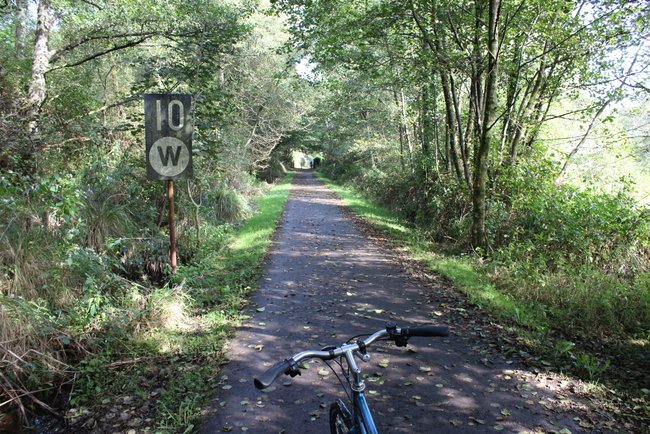
Below - A look along the former Porthcawl branch line towards Pyle.


 The path emerges on Victoria Road in Pyle close to the site of Kenfig Hill station, the only intermediate station between Pyle and Tondu.

Station Road still exists but houses have been built along the north side of the road where the station once stood leaving no remnants of the former station.
It is possible to follow the former railway as it curved around Kenfig Hill most of the way to where it passed under the mainline east of Pyle before curving round to the west to join the mainline at Pyle Junction. Subsequent development around Pyle has seen much of the course of the railway disappear.


From the roundabout at the end of Station Road a footpath follows the course of the railway to Croft Coch Road. A couple of bridges survive that once took the line over paths in to the old quarries. South of Croft Coch Road playing fields, a health centre and a car park have been built over the railway.


South of the Park Street car park the footpath continues along the course of the railway up to where it passed under the mainline. It does so as a footpath though and as I was on bike I continued in to Pyle but intend to return and check out the remains of the railway around Pyle on foot. The overbridge shown on the old map is shown as surviving on modern maps. South of the mainline the trackbed has been obliterated. The Google satellite images show the outline of where the connection to the mainline was in the field boundarys that still follow it, though the cutting has now been filled. 


Following the line to Porthcawl on the modern maps little survives. There is a bridge over the west facing chord (now at the corner of Cilgant Y Lein) and a stretch of trackbed between South Cornely and Nottage survives as a farm track, complete with a bridge over Moor Lane. The trackbed in to Porthcawl is now occupied by the A4106 and the former station site now a car park.

Saturday 23 April 2022

Ogmore Vale Line

Starting point - Sarn Station. Finishing Point - Commercial Street, Nantymoel. Distance 7.6 Miles

The cycle route that follows the Ogmore Vale line to Nant-y-moel follows the Ogmore River from Sarn up to where it meets the former railway at Brynmenyn. Having been covering a few lines in the area on bike I cycled from Brynmenyn (where I had returned from a trip up the Garw Valley Railway) up the Ogmore Vale line and returned to Sarn station but I'll put everything here in order from the Tondu end of the line.


Below - Former railway bridge where the south sides of the triangular junction of the Pencoed Branch crossed the Ogmore River.


Below - Looking towards Tondu along the abandoned railway line just west of the site of Brynmenyn station at the footpath crossing that is shown on the old map.


Below - The site of Brynmenyn station. The platform can be seen in the vegetation on the right. On the left the line to Blaengarw diverged with its own platforms.


1947 Map (top left of map)

Below - Just east of Brynmenyn a 10mph speed restriction sign and whistle board (for an un-gated crossing) survives as a reminder that the line survived for coal traffic in to the 1980s.


The line is shown on the old map as the Blackmill Branch. At Blackmill there was a junction with the "Little Ogmore Line" to Thomastown at the station. Nothing remains of the station.


Where the line met the Cardiff and Ogmore Railway at Cardiff and Ogmore Junction was the site of Lewistown Halt. Remains of the station can be seen in the vegetation at the side of the path. The Cardiff and Ogmore Railway connected to the Pencoed Branch, duplicating the triangular junction we passed the site of near Brynmenyn. It was quite an early closure.

Below - The former Lewistown Halt.


A park has been established at the site of Rhonda Main Colliery's Ann Pit. This includes a path along the wagonway that went on to an "Old Trial Level."


Below - The former Ogmore Vale station, originally named Tynewydd when it opened in 1873 but renamed in 1902.


Not far north of Ogmore Vale station was Wyndham Halt, situated between Penllwyngwent and Wyndham Collieries to serve both. Just a simple platform it doesn't show on the old maps. The platform survives.

Below - The former Wyndham Halt. 


The path just pops out onto Commercial Street at Nantymoel. The station has long since been demolished and the area grassed over.

Below - A modern piece of wall marks the start or end of the cycle route around where the platform edge would have once been.

Nantymoel was the terminus of the line. The line just continued to a headshunt for the run round loop in the now grassed over land on the west side of Commercial Street just before the road curves. From here I cycled back to Sarn station for a train to where I was staying.


Saturday 16 April 2022

Garw Valley Railway

Starting Point - Tondu Station. Finishing Point - Blaengarw. Distance 7.2 Miles

The line from Brynmenyn Junction just east of Tondu to Blaengarw at the head of the Garw Valley opened in 1876. Like most of the lines in the South Wales valleys it was built primarily to serve industry. Passenger facilities along the line were not provided until a decade or more after the line opened, although the line carried miners to and from the mines on the route. The line also closed to passengers before Beeching was even a glint in the eye of corrupt politicians, closing in 1953. The line remained open to coal traffic to the early 1990s. Much of it is now a cycle route and track is still in situ on parts of the route. A preservation scheme has also been established at Pontycymmer with the aim of reopening the route from Brynmenyn. More information about the heritage railway and the history of the line can be found on the Garw Valley Railway website.

Combining this route with a trip along the nearby Ogmore Valley line I visited by bike, starting at Tondu station.

1947 Map

Google Map 

From the junction immediately north of Tondu station the abandoned line is overgrown. There is a run round loop on the former trackbed immediately east of the junction, this is considered to be mothballed rather than abandoned. West of Tondu the line to Margam is also considered to be mothballed, in the past trains have been diverted on that route when there has been engineering work on the mainline, requiring running round at Tondu. It is some years since the last train ran that way.  

To pick up the cycle path along the line it is necessary to head to the Bryngarw Country Park north of Brynmenyn. A stretch of the trackbed before here is accessible from another cycle path to the south of the railway and on another visit to the area I visited this on foot.

Below - Just west of Brynmenyn the abandoned line towards Tondu can be seen alongside a cycle route. A "fixed distance signal" sign can be seen next to the line, this would have instructed drivers to approach the run round loop and junction at caution. 


Below - The site of Brynmenyn station and the junction where the Garw and Ogmore Vale lines diverged,
the Garw line branching off on the left from the Ogmore line which continues as a cycle route on the right. Remains of the platforms could be seen in the vegetation.
 

On my way to the Bryngarw Country Park I stopped at the former level crossing in Brynmenyn where the line crossed Abergarw Road close to the junction with Pleasant View that leads to the country park.

Below - Level crossing at Brynmenyn.

1947 Map

Below - Joining the trackbed in the country park and the disused track can be seen alongside the cycle route.

Below - The railway and path pass under Pandy Bridge north of Brynmenyn


1919 Map

At Llangeinor the former station is now in use as a house. The rails could still be seen in the road of the level crossing and a couple of single aspect signals and electrical equipment cupboards could be seen next to the line, presumably the signals would have had a flashing white light which would have told the driver that the crossing was closed to road traffic. Unfortunately I didn't get a photo of this.

1918 Map

1919 Map

Below - The base of the preservation scheme at Pontycymmer.

The heritage railway is situated around what was once the goods yard south of the passenger station. The bridge over the station site has been filled in so there is a slight detour along Prospect Place to pick up the former railway line.

Beyond Pontycymmer the water of the Afon Garw has been diverted to follow the former railway and the path runs alongside the stream. From former railway route with track still in place it quickly becomes barely evident that there ever was a railway there. The site of the collieries have been landscaped over returning the landscape of the area to a more rural appearance.

Below - North of Pontycymmer the path crosses a stream off the hills around Foel Gwilyim Hywel offering this nice scenic view.


The path emerges at an extended Blaengarw Road just north of where the bridge between Railway Terrace and New Road (now Pwllcarn Terrace) once crossed the railway. From here I returned to Brynmenyn and on to the Ogmore Valley line.


Saturday 9 April 2022

Tondu Ironworks

A short walk around the former Tondu Ironworks

My visit to Tondu Ironworks was back in 2013 at which time it was part of a heritage park with paths around the various historic buildings. Unfortunately that park closed in 2016 and soon became overgrown. The site has been put up for sale and the new owner of the site has recently submitted plans to turn the complex into a restaurant and hotel that will incorporate the Grade 2 listed buildings


Below - The former engine house before the currently planned conversion to a restaurant and hotel.


Below - The former engine house on the left and wagon hoist and lime kilns on the right.


Below - The wagon hoist and lime kilns.


Below - The former wagon hoist.


Below - Remains of the Beehive Coke Ovens along the northern edge of the site.


Part of the former ironworks complex is currently occupied by the Tondu Cycle Park. The area is now quite wooded. The main cycle path through the park runs along the former tramway that ran along the southern edge of the ironworks complex. Further housing redevelopment is being considered for this part of the site and though the plans show the former tramway course incorporated there will be a new road from the Fford Antwn roundabout to Maesteg Road cutting across it.

Below - Bridge that carried one tramway over another close to the Tondu Brewery. 


Saturday 2 April 2022

Sentinel Works, Shrewsbury

Starting Point - Shrewsbury Station. Round trip to former Sentinel Works. Distance 2.8 Miles


Above - Sentinel locomotive 68153 on the Middleton Railway. Below - Super Sentinel steam lorry.


In the early 20th Century several firms around the country produce steam powered lorries. They turned out to have a fairly short lived popularity, in the aftermath of the first world war the market was flooded with petrol and diesel powered lorries that had been used in the war effort. The war also saw massive develop of internal combustion engined machines on both rail and road. Sentinel's route go back to the Glasgow works of Alley & MacLellan who started making steam lorries in Glasgow in 1905 before establishing the Sentinel Works in Shrewsbury in 1915. The original designs carried on in production in Glasgow until 1923 when Sentinel introduced their updated Super Sentinel. The Glasgow office buildings used an innovative pre-fabricated concrete design and this was also employed at the Shrewsbury works with parts of the works cast in kit form in Scotland.
Sentinel also ventured in to building steam shunting locomotives based on their steam lorry designs. Their vertical boilers were quicker to raise steam and more suitable for one man operation so were handy for smaller industrial railway systems and more occasional than regular use. 
Steam lorries had a bit of a resurgence around the second world war in the face of fuel shortages and the country's abundant coal supply but internal combustion had taken over shortly after the war. The company was taken over by Rolls Royce with the intention of producing diesel engines at Shrewsbury. Diesel locomotive production also took place but lorry production didn't. In the mid 1960s Sentinel developed their Steelman loco, earmarked to replace many steam engines still operating in the steel industry. In the end redundant British Railways class 14 locomotives that had seen little use proved to be a cheaper option and the orders dried up. Eventually locomotive production within the Rolls Royce group moved to Sentinel's former agents and maintenance specialist Thomas Hill of Rotherham who had also become part of Rolls Royce. Thomas Hill undertook several orders to convert Sentinel steam locos to diesel power, being ideally suited for conversion due to their chain drive arrangement. They also produced new locomotives under the Vanguard brand name, Thomas Hill also took on the goodwill and designs of the Yorkshire Engine Co at nearby Meadow Hall whose works I saw on a previous railway walk covered here.

Below- Sentinel diesel shunter on the Llanelli & Mynydd Mawr Railway.


The Sentinel works carried on producing parts for aerospace engines through the Rolls Royce family of companies and subsequent changes of ownership. Most of the works survives today with part of the site having been redeveloped as a Morrisons supermarket.
More about the history of Sentinel can be found on the Wikipedia article
The former works is a 1.4 mile walk from Shrewsbiry station, following the A5191 for most of the way. 


On the way one interesting sight is the Shrewsbury Flaxmill Maltings. The mill was built for Thomas and Benjemin Benyon, pioneers of flax spinning and partners with Leeds Flax miller John Marshall who's Scotland Mill (near Leeds despite the name) and whose complex in Holbeck I have previously visited. I have yet to write up the visit to Scotland Mill but have previously covered the Holbeck mills in this article for the leedsengine.info website
Fires in the earlier mills of the industrial revolution were a common problem with many of the materials handled being quite flammable. This building addressed this problem by being build of brick around a cast iron frame. It is considered to be the grandparent of modern skyscrapers, such a historic building that parts of the complex have been given Grade 1, 2* and 2 listing. It operated as a Flax mill from 1797 to 1897, on closure it stood empty for around 10 years before being converted to a maltings as which it continued in use until 1987. At the time of my visit it was under restoration and largely obscured by scaffolding and surrounded by hording. At the time of writing it is about to reopen as a tourist attraction and offices so I'll visit another time when I can get a better look. More information, including a detailed history of the complex can be found on the Shrewsbury Flaxmill Maltings website.


Continuing to the site of the Sentinel works we pass a Morrisons supermarket, this occupies part of the former works though thankfully much of the works including the earlier buildings and key buildings such as the offices survive.

Below- The former main entrance to the works (now replaced with a side entrance more suitable of the larger lorries around now. The Sentinel and his sword of the company logo still stand guard over the gateway. 


Steam lorries can occasionally be seen at the front of the former works as being possibly the most successful steam lorry make several survive in preservation and many owners will pose their restored examples in front of the works if they are in the area. Another location on the Sentinel grand tour is the Horseshoe Pass near Llangollen, a steeply graded route often used as a test track for the machines produced here.
It is interesting to note the position of the houses on the opposite side of the street built diagonally to the main road to provide a turning circle to allow lorries in and out of the gateway.

Below - The office building at the front of the Sentinel works.


Below - Heading north east along the A5112 some of the original works buildings can be seen.

Below - The northern edge of the complex. To the right of the image was once the end of a siding connected to the nearby railway to Crewe. The site of the end of the siding is now occupied by a women's gym. I didn't point my camera at the gym to take photos.


The old map also shows a small siding on the northern edge of the site, this looks to have been for the purpose of supplying coal to the factory's engines. This is now well within the surviving complex.

Below - The current side entrance to the complex with some more of the surviving works buildings.


Below - The southern edge of the complex has been demolished and redeveloped with the Morrisons supermarket and the road in to it. The office building forming the southern edge of the surviving complex.