Starting point - Sarn Station. Finishing Point - Commercial Street, Nantymoel. Distance 7.6 Miles
The cycle route that follows the Ogmore Vale line to Nant-y-moel follows the Ogmore River from Sarn up to where it meets the former railway at Brynmenyn. Having been covering a few lines in the area on bike I cycled from Brynmenyn (where I had returned from a trip up the Garw Valley Railway) up the Ogmore Vale line and returned to Sarn station but I'll put everything here in order from the Tondu end of the line.
Below - Former railway bridge where the south sides of the triangular junction of the Pencoed Branch crossed the Ogmore River.
.JPG)
Below - Looking towards Tondu along the abandoned railway line just west of the site of Brynmenyn station at the footpath crossing that is shown on the old map.
.JPG)
Below - The site of Brynmenyn station. The platform can be seen in the vegetation on the right. On the left the line to Blaengarw diverged with its own platforms.
.JPG)
1947 Map (top left of map)
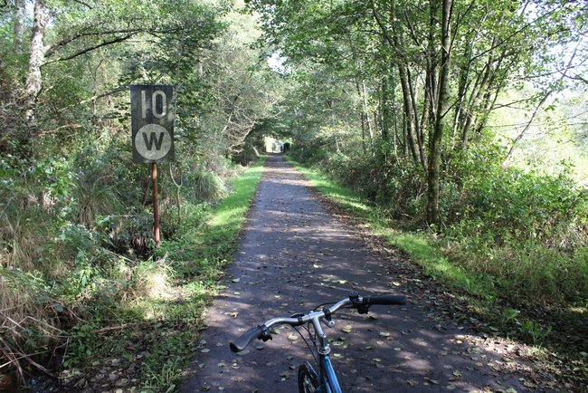
Below - Just east of Brynmenyn a 10mph speed restriction sign and whistle board (for an un-gated crossing) survives as a reminder that the line survived for coal traffic in to the 1980s.
The line is shown on the old map as the Blackmill Branch. At Blackmill there was a junction with the "Little Ogmore Line" to Thomastown at the station. Nothing remains of the station.
Where the line met the Cardiff and Ogmore Railway at Cardiff and Ogmore Junction was the site of Lewistown Halt. Remains of the station can be seen in the vegetation at the side of the path. The Cardiff and Ogmore Railway connected to the Pencoed Branch, duplicating the triangular junction we passed the site of near Brynmenyn. It was quite an early closure.
Below - The former Lewistown Halt.

A park has been established at the site of Rhonda Main Colliery's Ann Pit. This includes a path along the wagonway that went on to an "Old Trial Level."
Below - The former Ogmore Vale station, originally named Tynewydd when it opened in 1873 but renamed in 1902.


Not far north of Ogmore Vale station was Wyndham Halt, situated between Penllwyngwent and Wyndham Collieries to serve both. Just a simple platform it doesn't show on the old maps. The platform survives.
Below - The former Wyndham Halt.

The path just pops out onto Commercial Street at Nantymoel. The station has long since been demolished and the area grassed over.
Below - A modern piece of wall marks the start or end of the cycle route around where the platform edge would have once been.

Nantymoel was the terminus of the line. The line just continued to a headshunt for the run round loop in the now grassed over land on the west side of Commercial Street just before the road curves. From here I cycled back to Sarn station for a train to where I was staying.
No comments:
Post a Comment