Starting Point - Westerleigh, Finish Point - Wills Bridge, Distance 6.4 Miles
I ended up walking much of the Dramway Path in Gloucestershire by accident. I had been intending to cycle the Bristol to Bath Railway Path and part of the Somerset & Dorset Railway, however not far out of Bristol I had problems with my bike. A few spokes on my back wheel broke and the only way I could carry on with the bike was by removing the rear brakes. Rather than pushing on with the ride I decided to walk along the remains of an earlier wagonway that existed before the railway line and ran alongside to the east for much of the way.
The Dramway is the name given locally to the Avon and Gloucestershire Railway, opened in sections between 1830 and 1834 it carried coal from pits to the east of Bristol down to the River Avon. Much more about the route can be read on the Dramway Path leaflet (PDF).
1886 Map (1) 1887 Map (2) 1886 Map (3) 1883 Map (4)
I joined the trail just east of the former Mangotsfield railway station. Where Carsons Road crosses the A4174 the old railway route runs alongside the A4174 on the west and the Dramway runs alongside on the East. The later railway line took over the course of the Dramway near Shortwood. I followed the dramway / railway route to Westerleigh where a stub of the railway survives to serve an oil terminal. Though I stopped off at some of the sites whilst heading north I'll put them in order from north to south to make it easier to follow.
Not far south of Westerleigh is the chymney of Parkfield Colliery. The other colliery buildings are gone and private housing occupies the colliery site.
Below - Parkfield Colliery chymney and the Dramway tramway route

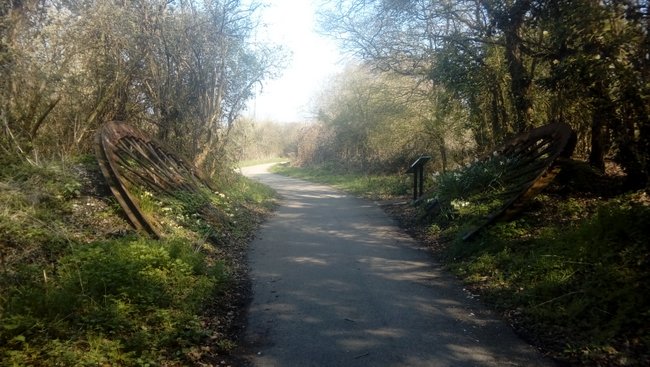
A much better survivor however is Brandy Bottom Colliery with many of the buildings surviving. At the north end of the site is what appears to be a weighbridge building alongside the former railway.

The two halves of a colliery winding wheel are placed either side of the path to mark the site of Brandy Bottom Colliery.


Returning to where we joined the Dramway at the roundabout on the A4174 and Carsons Road near Mangotsfield and looking at the old and new maps the original curve in the dramway that the later railway route smoothed out can be seen and can be followed as a path. Zooming in enough on the Google map shows the Dramway name on the path. That path can be picked up again on the other side of the A4174, again marked as a dotted line of a footpath rather than the cycle route which is the later railway route. The dramway is again to the east of the original railway route. The path can be followed as far as the Hare Brewery at Warmley, from here people following the route are directed to the later railway route.
Looking at the satellite images on Google maps the route can be seen around the back of the buildings on the east side of High Street at Oldland Common, however apart from a small section of driveway there is no path at this point, just the boundry between the buildings and adjoining fields marking the former dramway route. The route similarly continues to the west side of High Street where the boundries of properties on School Road and Saint Annes Drive meet. The Dramway path pickes up the course of the old wagonway again off Cherry Garden Lane to Willsbridge Mill. From here there would have been a short tunnel and the remaining route down to the River Avon seems to be lost in the fields.
No comments:
Post a Comment