Starting Point - Newbrough Bunk House. Finishing Point - Corbridge Station. Distance - 14 Miles

Day 3 - Newbrough to Corbridge (this page)
Below - Map of following the route of Hadrian's Wall with the Tyne Valley railway (click to enlarge). A few closed stations along the route make it difficult to visit the wall by day trips so I have stopped off at hostels in Greenhead and Newbrough to walk the highlights of the wall from Brampton to Corbridge over three days.

Starting from my accommodation at Newbrough Bunkhouse I walked to Chesters Roman Fort and Museum at Chollerford, aiming for it opening at 10am. The fort and museum is run by English Heritage, more information on their website.
This is another substantial fort like those on Day 1 at Birdoswald and Magna (at the Roman Army Museum) and on Day 2 at Great Chesters and Housesteads, rather than the regular Milecastles seen (where remains have been excavated) at Roman Mile intervals along the wall.
Evidence from excavations at the site suggest that this fort was added after the wall was built with the foundations of the wall and turret 27a beneath the fort buildings. A strengthening of the military presence along the wall from the original system of the Milecastles.
Below - Map of the Chesters fort site in the adjoining Clayton Museum, named after Victorian antiquarian John Clayton who excavated the site. The museum contains many of the finds from the site and is included in the site admission. (Click to Enlarge)

Below - Information panel at the entrance to the fort site (click to enlarge).

Below - The North Gate of the fort site heading out to the lands north of the wall.


Below - Barracks buildings. These would have been divided with Roman soldiers sharing a block with their horses.


Below - The fort's main East Gate heading out towards the bridge over the River North Tyne.

Below - Information panel at the east gate (click to enlarge).

Below - Heading to the river a short stretch of Hadrian's Wall can be seen.

Below - Looking across the river at the site of the former bridge, more of the bridge can be seen on the other bank which I'll come to later.


Below - Outside the main entrance to the fort complex (as often the case) was a bath house and the remains of this one are considered to be the best example of surviving Roman bath house in the UK.


Below - A block of latrines outside the bath house.

Below - The Headquarters building.


Below - The vault in which pay for the soldiers was kept.

Below - With the fort straddling the wall it had two East and West gates with smaller gates on the north side of the wall as well as the main East and West gates on the Roman side of the wall.


Below - A row of columns .

Below - A turret on the south east corner of the fort's walls.

Below - Another turret in the fort walls.

Below - The south gate.


Below - The West gate.


Below - Inside the Clayton Museum are some of the finds from the fort site.

From Chesters Fort I went to visit the remains of the east end of the bridge over the River North Tyne. To reach the site of the Roman bridge I had to cross the modern (1785 built) bridge. Across the bridge was Humshaugh Railway Station on the North British Railway's Borders Counties Railway between Hexham and Riccarton Junction. The station building is in use as a house now and is just visible through the trees around it. Reaching the remains of the Roman bridge involves a walk on a short stretch of footpath alongside the former trackbed of the railway which operated between 1858 and 1958.
Below - Former railway bridge under the B6318 Military Road, Humshaugh station was on the other side of the bridge.

The roman bridge site is managed by English Heritage but is free to visit. More information can be found on their website.
Below - Stretch of Hadrian's Wall up to the bridge with a turret that overlooked the bridge and matched another on the opposite bank. The roadway ramp up to the bridge would have been on the left here.
Below - Information board at this viewpoint with an artists impression of the bridge from this point, in this case the second wider bridge. (click to enlarge)

Below - View of the bridge abutment. Remnants of the roadway ramp can be seen on the right.


Below - Information board showing the two phases of the bridge on the site.


Returning to the B6318 there are a couple more traces of Hadrian's Wall nearby around the village of Brunton. Just off Front Street is a stretch of wall including the Brunton Turret, also managed by English Heritage and free to visit (website).
Below - Stretch of wall at Brunton.

Below - Brunton Turret (26b)


Below - It can be seen that the wall was narrower for a stretch to the east of Brunton Turret.

The path doesn't emerge east of Brunton Turret so it is neccessary to double back to the B6318, known at this point as Brunton Bank. The Hadrian's Wall Path runs parralell to the road on the south side.
Below - The stretch of wall at Planetrees, the change of wall width can be seen again and an explanation is provided on the information board. English Heritage page about the site.


East of here there is little in the way of wall remains, much of it was lost in this area when the Military Road was built along the route of the roman road in the wake of the Jacobite Rebellion.
Below - Though the wall has disappeared there are plenty of signs of the ditches dug alongside the wall.


From the Hadrian's Wall Path I followed the roads through Sandhoe (avoiding walking along the A68) to Corbridge Roman Town.
Corbridge Roman Town is managed by English Heritage and is open 10am to 5pm with an admission fee which includes an adjoining museum with displays and finds from the site. More information can be found on the English Heritage website.
Unlike other similar large sites along the wall which have been primarily military in nature this site preserves a stretch of the main street through Corbridge's Roman town which was built long before the work on the wall began, though inevitably the town expanded with the nearby frontier and gained a large military presence, becoming the most northerly town in the Roman Empire. The name was derived from Coria which means a local tribal centre.
Below - Information board at the site entrance (click to enlarge).

Below - Looking across the partly excavated site with a couple of granaries in the foreground.

Below - Looking along the main road, this was part of Stanegate, the Roman road that ran along the wall. Stanegate was replaced as the main route through the area by the Military Road in the Jacobite era but a few stretches of the Roman road have cropped up on my walk and it continues to serve some of the villages off the main road to the south of the wall.


Below - The ventilated floor of the granaries.


Below - A military barracks in the town.


Below - Remains of a large un-finished villa.

Below - Looking back along Stanegate. The museum can be seen on the right.

Below - The villa site.

Below - The wall of the military site.

Below - Evidence of subsidence in the foundations of the buildings in the town.

Below - The Principa headquarters building.

Below - The vault for the soldiers pay.


Below - Remains of a water tank on the right of the picture.

Below - Another information board about Corbridge Roman Town on the town's railway station.

Below - There were many finds in the museum buildings including items from the Corbridge Hoard. Below is the Corbridge Dodecahedron, these have turned up all over the Roman Empire and are of particular interest to historians as no one really knows what they were for.

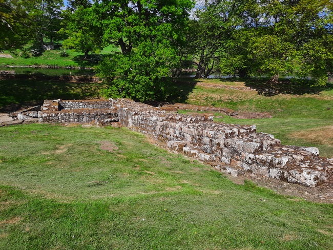
There was a Roman bridge across the River Tyne at Corbridge, on the south bank of the river a bit of the bridge survives. Google maps seems to suggest swimming across the river from the north bank, though to the south of the modern bridge a footpath runs along the river bank.
The remnant of bridge has infact been moved stone by stone south from its original position alongside the river to protect it from erosion. The wall is part of the ramp up to the bridge.
Below - Remnant of the bridge.


Also south of the river is Corbridge station on the Tyne Valley railway line. With only a few small fragments of wall between here and Newcastle I got the train from here in to Newcastle to visit the next major site at Wallsend the following day after a night in Newcastle. I subsequently went back as a day trip to visit those few fragments of wall I'd skipped.
Below - The station building at Corbridge, now a curry house as the station is now unstaffed.


No comments:
Post a Comment