Starting Point - Greenhead Hostel. Finishing Point - Newbrough Bunkhouse. Distance 24.2 miles.

Day 2 - Greenhead to Newbrough (this page)

The previous day I had walked from Brampton to Greenhead on my walk of Hadrian's Wall. From my accommodation at the Greenhead Hostel I returned to where I left the Hadrian's Wall Path at the Roman Army Museum. Across the road from the museum is the Walltown Country Park. There is a visitor centre in the park but I was pretty much there at first light, some time before it opened. Walltown Country Park is in a former quarry that had obliterated a short stretch of the wall, the Hadrian's Wall Path passes through the park to pick up the wall again on the hill above the quarry.


Below - Walltown Crags Turret 45a

Below - Information board at the turret (click to enlarge)

Below - Turret 44b.

Below - Walltown Crags had a good view from its hilltop position, though with my early start it was a bit misty.

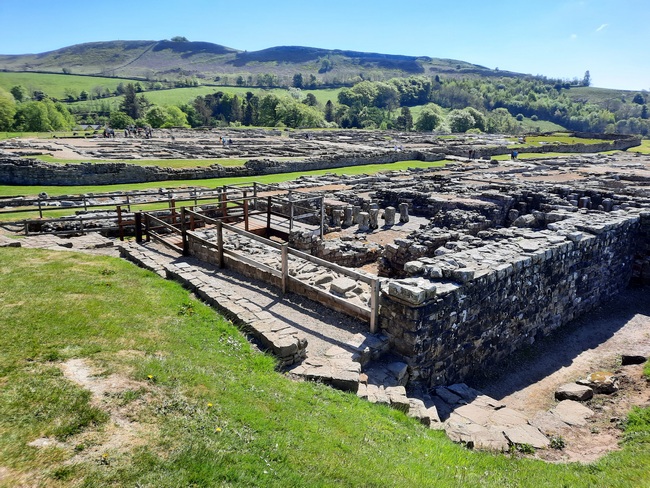
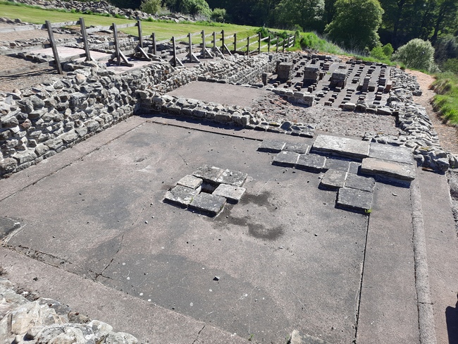
Below - Great Chesters Fort / Milecastle 43. Some of the features have been excavated here and it is free to walk round. The site is larger than most of the Milecastles.


Below - An alter from a temple in the corner of the fort.

Below - The wall follows rocky outcrops that greatly added to the security of the wall. The mist started to clear revealing dramatic views that the photos don't do justice to.

Below - Cawfields, Milecastle 42. One of the regular small gateways in the wall.


Below - The wall following the ridge of the hills with great views in both diretions.

Below - Caw Gap, Turret 41a.


Below - The highest point on the wall, and another walker takes a short rest. It's all downhill from here, apart from all the uphill bits.


Where the Hadrian's Wall Path passes Peel Cottage I left the path to take a detour to visit Vindolanda, a partly excavated Roman fort and museum. A joint ticket was available with the Roman Army Museum I visited the day before. More information about Vindolanda can be found on their website.
Below - The road to Vindolanda follows a short stretch of the Roman road Stanegate. The cycle route 72 follows Stanegate but the road was replaced as a main route by the Military Road during the Jacobite rebellion, now the B6318. On the way to Vindolanda the remains if a Milepost can be seen. Apparently to the east of Vindolanda one still survives to full height but I didn't add to the detour to see it.

Below - A temple on the edge of the Vindolanda site.


Below - The road to the fort with the village that grew up around it.

Below - A bath house on the edge of the fort site.


Below - The raised floors of graneries, built to keep the grain ventilated.

Below - A reconstruction of a temple close to the museum.

Below - A small house built outside the walls of the fort.

Below - The south gate of the fort.

Below - An early bath house south of the fort. This was in use before the wall was built.
Below - The Principia Headquarters building.


Below - Excavations taking place on the fort site.

Below - The north gate of the fort.

Below - A temple. The alters are modern reconstruction of originals now in the museum to prevent them deteriorating.

Below - Looking across the buildings in the fort complex.


Below - Looking back towards the entrance of the site from the west gate, looking across the civilian village that grew up around the fort.

Below - The west gate.

Below - A reconstruction of the original turf and wood version of Hadrian's Wall.

Below - A reconstruction of Hadrian's Wall and one of its turrets.


Below - Returning to the wall near Peel Cottage.


Below - Remains of a turret.

Below - Milecastle 39.


Below - The Sycamore Gap with the famous tree having been felled by vandals the year before.


Below - Milecastle 37.


Below - Milecastle 37 retains part of the arch of its gateway in the wall.

Below - The wall passes through a small wood.

Below - Housesteads Fort, or Vercovicium. This is another fort that was more substantial than the regular Milecastles and the site is now managed by English Heritage, website. The fort was added to the wall after its construction, replacing the original turret 36b.

Below - The west gate.

Below - The south gate.

Below - An inn outside the walls of the fort.

Below - The wall of the fort with the governor's building and headquarters building behind visible over the wall. I didn't actually visit the inside of the fort as it was very similar to Birdoswald I visited the day before. I had just visited the much larger Vindolanda site and was covering the largest distance on my second day so I was concerned about the time.

Below - The south east corner of the fort with the latrines. These are said to be one of the best preserved Roman latrines in the UK.

Below - The north east corner of the forth where it meets the wall.

Below - The wall heading east from the fort.

Below - A short distance from Housesteads fort was Knag Burn Gate. This is unusual in that the gates were generally at the forts / Milecastles. This gate was likely added later to avoid the steep climb in and out of the fort that can be seen to the right of the picture.


Below - Another ordnance survey pillar at the sumit of another of the hills the wall followed.

Below - Sewingshields Turret.


BeloBelow - The Sewingshields stretch of wall.


Below - Sewingshields Milecastle 35.


Below - Grindon Turret 34a


Below - A stretch of wall that has disappeared but the ditches remain. In the trees would have been Grindon Milecastle 34, any remains haven't been excavated. The ditch seen is on the north side of the wall but ditches, called vallum, were dug on both sides to defend the wall from attacks on either side.

Below - A tatty old information board at Milecastle 34.

Below - Another piece of wall and turret. The remnants of wall become a bit more scarce east of the stretch at Sewingshields.

Below - A sign for the Carrawburgh Roman Fort, though just earthworks and mounds over what was likely buried rubble and foundations of the fort can be seen from the paths through and around it.

Below - The Brocolitia Roman Fort at Carrawburgh isn't excavated but to the south of the fort the remains of the Temple of Mithras can be seen.


Below - A section of ditch that has been cut through rock. Though the traces of the wall in this area are a bit intermitent, there are plenty of surviving ditches.

Below - The short stretch of wall at Black Carts.


Below - Black Carts Turret 29a.


From Black Carts I left the wall path for my accommodation at Newbrough Bunk House Website. This is next to the Town Hall in a former Women's Institute building and is run by the parish council. An honesty cupboard of various food and other supplies is provided in the kitchen.
No comments:
Post a Comment