Starting Point - Site of Hayling Island Station. Finishing Point - Havant Station. Distance 6.7 Miles
From my walks around the Isle of Wight I took the Hovercraft to Southsea, from there bus route 25 connects with Eastney Landing on the Hayling Ferry. Hayling Island had a branch line from Havant from 1867 to 1963, nicknamed the Hayling Billy. Due to weight limits on the viaduct from Langstone to Hayling Island only small lightweight locomotives could be used on the services and former London, Brighton & South Coast Railway A1 "Terriers" operated the services until the line closed in 1963. The expensive repairs required to the bridge to keep the line open was the reason for the closure of the line.
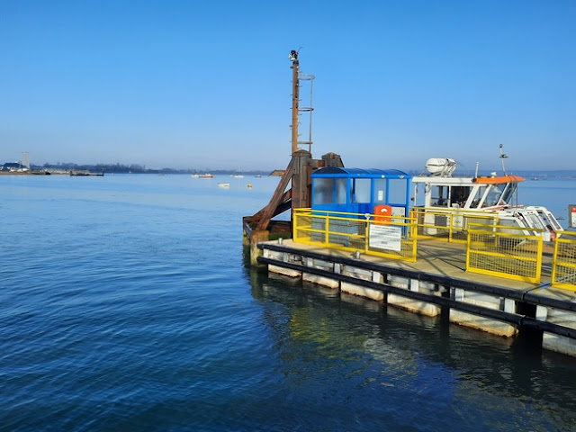
Below - Eastney Landing and the Hayling Ferry.
Below - The ferry at Hayling Island Landing, the Eastney landing can be seen in the background.
The start of the footpath along the former Hayling Island branchline was reached by walking along Ferry Road, Sea Front and Staunton Road. The station is on the top right of the old map.
Below - World War II pill box on Ferry Road. Being on the south coast there were quite a few pieces of World War II defences on the way.
Hayling Island
Below - The only remnant of the station was the goods shed which now forms part of the Station Theater. A foyer has been built on to the front of the former goods shed building.
Below - The former goods shed.
Below - This building was opposite the station, it isn't marked as such on the old maps but from the doors facing towards the station site I expect this must have been the station manager's house.
Below - A view towards the former platforms.
Below - A view along the trackbed north of the station site.
Below - The trackbed running close to the west coast of the island.
Below - A brick built pill box alongside the railway.
An earlier scheme to build a railway to Hayling Island would have seen a causeway embankment built on mud flats to the west of the island to a point close to the island's ferry landing. The line was constructed south from Havant to Langstone and work was started on the embankment but this was never completed. Remnants of the embankment can be seen.
Below - The trackbed of the railway on the right with the embankment of the earlier scheme on the left.
Below - The abandoned embankment seen rising above the water.
North Hayling Halt
A small unstaffed halt was provided to serve built up areas to the north of the island.
Below - The site of North Hayling Halt.
Below - Information board at the site of North Hayling Halt.
The bridge from Langstone to Hayling Island had a swing bridge in the centre to allow the passage of larger boats so signals were provided before the bridge. One of these signals is in situ, though it is a reconstruction.
Below - Looking north, the signal and remains of the bridge.
Below - Remains of the bridge. Alongside the surviving road bridge can be seen. To get to Havant it was necessary to divert via the road bridge.
Below - View of the remnants of the rail bridge. The column for the swinging section can be seen in the centre.
At the north end of the road bridge there was a siding to the west of the road. At one side this was used to serve a train ferry to Bembridge on the Isle of Wight, this was prior to the railway at Ryde being extended to the pier. The site of the ferry jetty is now occupied by the Langstone Sailing Club.
Below - The bridge looking south from Langstone.
Below - A former telephone cabinet at the side of the railway.
Langstone
Below - The site of Langstone station looking north.
Below - The station site looking south from the former level crossing.
Below - Bridge taking the A27 over the former railway.
Below - The bridge taking East Street over the former railway.
Below - The former Gas House Road level crossing, now named New Lane. This is the end of the route as beyond the crossing it enters the station car park built on the site of the Hayling Island bay platform and siding.


No comments:
Post a Comment