Starting Point - Hull Arena. Round trip about 3 miles.
Hull's earliest docks formed a ring around the west of the old town with the River Hull along the east. With the expansion of the docks in the Victorian era, fuelled by the railways bringing in goods for export from across Yorkshire and beyond, additional docks were established alongside the River Humber beginning with Victoria Dock to the east and Albert Dock to the west.
Prior to the construction of the Humber ports a footpath had existed along the banks of the River Humber and, probably to the annoyance of the dock companies, the right of way survived the construction of the docks.
In 1904 the North Eastern Railway applied to build a quay on the Humber adjacent to Albert Dock, permission being granted the following year. The idea behind this was to provide mooring on the river particularly for perishable goods such as fruit, saving the time waiting to use the locks to enter the dock. It also provided a departure point for ferries to mainland Europe.
While it might have spelt the end for the footpath along the Humber having warehousing facing the dock to the north and river to the south, the path had to stay and remarkably the way to achieve this was to run the path along the roof of the warehouses where it survives to this day.
Much more about the history of Hull's docks can be read on the Wikipedia article
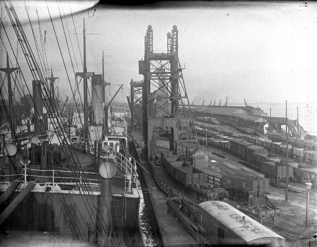
Below - Picture from a National Railway Museum article showing Albert Dock and Riverside Quay on the right. Note the steps on the right to gain access to the path along the warehouse roofs. The platform can be seen of the Riverside Quay railway station, built to connect with the steamers to Europe.

I began the visit of the site today by parking my bike up at Hull Arena, the path begins at the roundabout on Wellington Street West and Manor House Street, what would once have been one of the main road entrances. The entrance to the path doesn't look particularly inviting these days, between two high pallasaid fences.
The former security office can be seen on the right of the above picture. A plaque on it notes the 1970s reconstruction as the main fish dock for Hull. Previously this role had been fulfilled by St Andrew's Dock to the west of here (we end up there on this walk) but Hull's docks were down-sized in the 1970s with the closure of St Andrews Dock, Victoria Dock and the original docks around the old town. Grimsby has since eclipsed Hull as a fishing port.
Below - The path crosses over the lock gates to get to the south side of Albert Dock.
On my return I found the lock gates open and with no sign of a ship approaching had to ring the phone number posted on the lock office. The call was answered from King George Dock and I was told the gates had just been opened for high tide and would be closing in the next 10 minutes. The gates then closed, which was a relief as otherwise I would have had a long walk around to get back to my bike.
Below - The steps up to the rooftop path.
Below - Some views from the top of the warehouses. Note the remnants of railway lines set in to the concrete of the docksides, the dock is no longer connected to the railway network. The old photo at the top of the page shows coal hoists, these are long gone with the coal traffic having moved to the ports in East Hull when these were built. In more recent years King George Dock has imported coal. Crawler cranes can now be seen on the docksides. Looking at the loads around the docks some of the key products are timber and steel.
Below - A look along the elevated path.

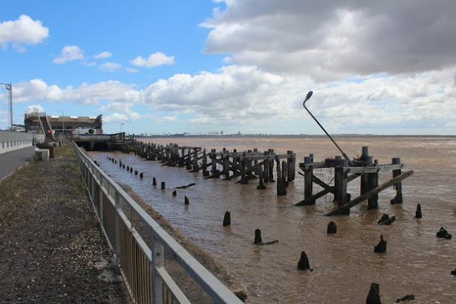
Below - At the end of the row of warehouses the path descends to ground level. The concrete warehouses are post World War II, extensive damage having been done to the dock in the war. Note the remnants of the Riverside Quay.

Below - Another look at the abandoned stretch of Riverside Quay, complete with lamp post, at least for the time being.
Below - Another archive view of Riverside Quay station, taken from Wikipedia
Below - Beyond the warehouse we get fairly close to a couple of ships on the dock. This part of the dock is a later extension named William Wright Dock after the chairman of the dock company. This part of the dock has been largely used for maintaining Hull's trawlers and other ships.
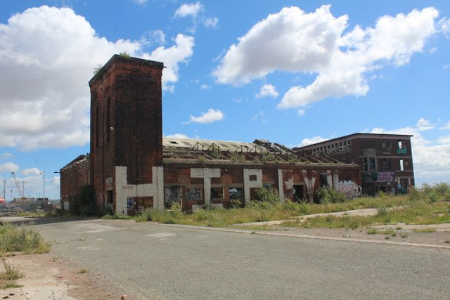
Past William Wright Dock we reach the abandoned St Andrew's Dock. Though part of St Andrew's Dock was redeveloped as the St Andrew's Quay retail park, the eastern edge of the site remains abandoned and derelict.
Below - The once splendid Art Deco Insurance Building at the former lock entrance to St Andrew's Dock
Below - The former lock entrance to St Andrew's Dock
Below - Pumping Station No2
Most well known of the decaying buildings at this end of St Andrew's Dock is the Lord Line building. Again a post war building, opened in 1949 as the headquarters of Lord Line, then the worlds largest deep water fishing fleet. The building has remained derelict and has deteriorated since the closure of St Andrew's Dock in the mid 1970s. Plans to demolish it have met with strong local opposition as many would like to see it restored given its connection to the local fishing industry history. Several warehouses along St Andrew's dock that have been considered to be eye sores that don't fit in with regeneration plans have burned down over the years so it is a testement to the construction methods of the era that the Lord Line building has escaped this fate.
More about the Lord Line building, together with an explore inside the building can be found on the
28 Days Later site.
From here I returned to the entrance near Hull Arena, though in retrospect it would make an interesting round trip to return via Hessle Road, once the heart of the fishing industry community.
This walk was covered in a
Hull Daily Mail article. I found surprisingly little on this interesting walk when I looked prior to the walk. It had been closed for a while due to flood defence work and I wasn't sure if I'd even find it open.


No comments:
Post a Comment