BROWSE JOURNEYS BY MAP VIEW

Saturday 29 May 2021

Hull Riverside Quay


Starting Point - Hull Arena. Round trip about 3 miles.

Hull's earliest docks formed a ring around the west of the old town with the River Hull along the east. With the expansion of the docks in the Victorian era, fuelled by the railways bringing in goods for export from across Yorkshire and beyond, additional docks were established alongside the River Humber beginning with Victoria Dock to the east and Albert Dock to the west.  

Prior to the construction of the Humber ports a footpath had existed along the banks of the River Humber and, probably to the annoyance of the dock companies, the right of way survived the construction of the docks.

In 1904 the North Eastern Railway applied to build a quay on the Humber adjacent to Albert Dock, permission being granted the following year. The idea behind this was to provide mooring on the river particularly for perishable goods such as fruit, saving the time waiting to use the locks to enter the dock. It also provided a departure point for ferries to mainland Europe.

While it might have spelt the end for the footpath along the Humber having warehousing facing the dock to the north and river to the south, the path had to stay and remarkably the way to achieve this was to run the path along the roof of the warehouses where it survives to this day.

Much more about the history of Hull's docks can be read on the Wikipedia article

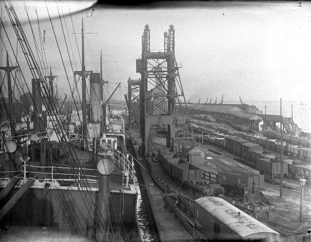
Below - Picture from a National Railway Museum article showing Albert Dock and Riverside Quay on the right. Note the steps on the right to gain access to the path along the warehouse roofs. The platform can be seen of the Riverside Quay railway station, built to connect with the steamers to Europe.

I began the visit of the site today by parking my bike up at Hull Arena, the path begins at the roundabout on Wellington Street West and Manor House Street, what would once have been one of the main road entrances. The entrance to the path doesn't look particularly inviting these days, between two high pallasaid fences.

The former security office can be seen on the right of the above picture. A plaque on it notes the 1970s reconstruction as the main fish dock for Hull. Previously this role had been fulfilled by St Andrew's Dock to the west of here (we end up there on this walk) but Hull's docks were down-sized in the 1970s with the closure of St Andrews Dock, Victoria Dock and the original docks around the old town. Grimsby has since eclipsed Hull as a fishing port.


Below - The path crosses over the lock gates to get to the south side of Albert Dock.
On my return I found the lock gates open and with no sign of a ship approaching had to ring the phone number posted on the lock office. The call was answered from King George Dock and I was told the gates had just been opened for high tide and would be closing in the next 10 minutes. The gates then closed, which was a relief as otherwise I would have had a long walk around to get back to my bike.


Below - The steps up to the rooftop path.


Below - Some views from the top of the warehouses. Note the remnants of railway lines set in to the concrete of the docksides, the dock is no longer connected to the railway network. The old photo at the top of the page shows coal hoists, these are long gone with the coal traffic having moved to the ports in East Hull when these were built. In more recent years King George Dock has imported coal. Crawler cranes can now be seen on the docksides. Looking at the loads around the docks some of the key products are timber and steel.


Below - A look along the elevated path.


Below - At the end of the row of warehouses the path descends to ground level. The concrete warehouses are post World War II, extensive damage having been done to the dock in the war. Note the remnants of the Riverside Quay.


Below - Another look at the abandoned stretch of Riverside Quay, complete with lamp post, at least for the time being.


Below - Another archive view of Riverside Quay station, taken from Wikipedia


Below - Beyond the warehouse we get fairly close to a couple of ships on the dock. This part of the dock is a later extension named William Wright Dock after the chairman of the dock company. This part of the dock has been largely used for maintaining Hull's trawlers and other ships.


Past William Wright Dock we reach the abandoned St Andrew's Dock. Though part of St Andrew's Dock was redeveloped as the St Andrew's Quay retail park, the eastern edge of the site remains abandoned and derelict.

Below - The  once splendid Art Deco Insurance Building at the former lock entrance to St Andrew's Dock


Below - The former lock entrance to St Andrew's Dock


Below - Pumping Station No2 


Most well known of the decaying buildings at this end of St Andrew's Dock is the Lord Line building. Again a post war building, opened in 1949 as the headquarters of Lord Line, then the worlds largest deep water fishing fleet. The building has remained derelict and has deteriorated since the closure of St Andrew's Dock in the mid 1970s. Plans to demolish it have met with strong local opposition as many would like to see it restored given its connection to the local fishing industry history. Several warehouses along St Andrew's dock that have been considered to be eye sores that don't fit in with regeneration plans have burned down over the years so it is a testement to the construction methods of the era that the Lord Line building has escaped this fate.


More about the Lord Line building, together with an explore inside the building can be found on the 28 Days Later site.

From here I returned to the entrance near Hull Arena, though in retrospect it would make an interesting round trip to return via Hessle Road, once the heart of the fishing industry community.

This walk was covered in a Hull Daily Mail article. I found surprisingly little on this interesting walk when I looked prior to the walk. It had been closed for a while due to flood defence work and I wasn't sure if I'd even find it open.


Saturday 22 May 2021

Baliff Bridge Branch Railway

Starting Point - Brighouse Station. Finish Point - Low Moor Station. Distance 5.5 miles. 


Construction of the Baliff Bridge Branch Railway, or Pickle Bridge Line, began in 1874. It provided the Lancashire & Yorkshire Railway a more direct route between Bradford and Huddersfield / Mirfield than the routes through Halifax and Cleckheaton. It had two intermediate stations, Clifton Road on the outskirts of Brighouse and Baliff Bridge. More about the line can be read on the Wikipedia article.
Below - The former Clifton Road station. The site of the platforms can be seen at the top of the wall. The station closed to passengers in 1931. The railway used to continue over the road behind me on a viaduct. The track on the left is the former station approach road.


Though the viaduct is gone, the railway trackbed can be joined on the other side of the road and it forms a path through Wellholm Park Woodland. The next major structure on the railway was Thornhills Viaduct which is still intact but is fenced off at both ends, the path goes down to the road beneath and back up to the trackbed at the other side of the road.


Below - Thornhills Viaduct.


For a short stretch north of Thornhills Viaduct the path doesn't follow the railway but run alongside to the west along the edge of a farmers field. The railway was in a cutting at this point but this has now been filled in. The path leads out to a modern housing development but at the end of Fairfield Rise it leads back on to the railway trackbed. Once back on the trackbed a small bridge that once took the railway over Low Lane can be seen.


North of here there was once a station here to serve Baliff Bridge, though this closed in 1917. The station was of wooden construction and burned down in 1929.

Below - Photo of the site of Baliff Bridge station in 1961. (Wikipedia)


The bridge over Birkby Lane in the above photo survives. (Below)


We continue along the railway trackbed until Lower Wyke Lane where housing development in Wyke has seen a small section of trackbed built on.


Below - Bridge abutment at Lower Wyke Lane.


A row of houses on Lower Wyke Lane is built on the site of the railway, however where the road curves sharply to the right a footpath crosses the former railway line to Mayfield Grove and someone has a railway bridge in their garden.


Turning Right off Mayfield Grove on to Bradford Road and the bridge over Bradford Road has been demolished, the abutments can still be seen.


The next major structure is Wyke Viaduct. This will be familiar to many people from West Yorkshire in that it now provided the unusual landmark where half of it is still standing and half of it isn't. 

Below - Surviving part of Wyke Viaduct crossing the A58


It was this viaduct that would be the Achilles heel of the line. There were several mines in the area (more about that shortly) and the viaduct suffered from subsidence. Speed restrictions were implemented for a time but passenger services were diverted to other routes in 1948, the intermediate stations on the line had all closed by this stage anyway. The line closed completely in 1952. Wyke Viaduct survived until 1987 but with increasing risk of collapse BR applied to demolish part of the viaduct despite it being listed. 
Below - The truncated Wyke Viaduct.


Below - Just beyond the missing bit of viaduct a couple of bridges can be seen, the one on the left crossed a railway to one of the mines that was likely undermining the viaduct. The bridge on the right crossed a farm track.


Just north of here the railway joined the main Calder Valley route between Bradford and Halifax at what was once known as Pickle Bridge Junction, The Pickle Bridge Line being another name by which this line is called. Obviously this is no good for walking and it is a bit of a trek to the next station on that route at Low Moor now that there is no longer a station at Wyke, however there is a handy bit of the mine railway to follow. A footpath runs parallel to the old railway and crosses the Calder Valley line. Continuing on to Station Road (where Wyke Station used to be) on the left hand side we enter Doctor Wood. A path through the wood picks up the mineral railway.

1893 Map (Mineral Railway on the bottom right of the sheet)
The path along the mineral railway leaves the woods and continues up to where the Appleton Academy has recently been built. This seems to be quite an incline and was presumably rope worked at this stage.


From here we head to Wilson Road which takes us to Low Moor Banks, an area that was also covered in coal mines and the railways that connected them. The path to Low Moor station takes us along one side of the triangular junction of the former Cleckheaton Branch line. The former Cleckheaton line is now a footpath and cycle route all the way to Thornhill where it met the line to Horbury Junction near Wakefield.


Saturday 15 May 2021

Old Coal Tramways Around Stanley

Starting Point - Outwood Station. Leg 1: to Bottom Boat - 3.1 miles. Back to Canal Lane - 2 miles. Leg 2: Canal Lane to Stanley Ferry 1.5 miles.

Current Map 1854 Map

The area around Outwood - Lofthouse - Stanley was once covered in collieries and with that tramways to take the coal to the River Calder for onward transport in the days before the railways domitated that business.

Though the area has been redeveloped with housing in the subsequent centuries, it is still possible to follow some of the tramways and even see a few traces of their existance today.

Some of the early tramways were affected by the construction of the later Methley Joint Line, much of which survives as a footpath / cycle route we will cross a few times.

Below - Routes of early coal tramways superimposed on a modern map (Map - OpenStreetMap)


Below - Memorial at the site of Lofthouse Colliery.

Starting at Outwood station, land adjacent to the station that now forms parkland was previously Lofthouse Colliery. From here we really go back in to railway history as the first tramway we look for was the Lake Lock Railroad. This line is said to have been the world's first public railway when it was formed in 1796. Unlike earlier schemes that were developed by the collieries they served, this was built by a variety of financial backers and open to any colliery owners prepared to pay the toll to use it. The line was built with edge rails to a gauge of 3ft 4 3/4 inch, this of course being before the days of a standard gauge. The Lake Lock Railroad closed in 1836 and new waggonways with what had become conventional rails for flanged wagons were built following the same or similar routes to carry on the job of taking coal from the mines to the Navigation. More can be read about the Lake Lock Railroad on the Wikipedia article and the Stanley History Online page.

Directly across Potovens Lane from the colliery memorial is a passageway and this is on a small stretch of the Lake Lock Railroad. It can be seen that this is on a slight embankment, the line having being engineered so that a horse could haul a few wagons on an average gradient of 1 in 70 down to the river.


After this short stretch we loose the trackbed under housing and have to follow the roads to Canal Lane. Where it meets Baker Lane we see the tramway to Stanley Ferrey and the walls of a filled in bridge, we'll come back to these. At this point the Lake Lock Railroad was alongside Canal Lane for a short bit before Canal Lane curves off to the north.

Taking Woolford Lane it leads to a small park and a path through it called Elgar Walk which is around where the line would have been, but any trace has been landscaped away. It is a case here of following the roads to reach the corner of Mount Road and Lake Lock Road. Until 1804 the tramway continued along Lake Lock Road and on to staith on the River Calder behind where the houses on Lake Yard are now. No trace remains but a blue plaque marks the course of the railway at the Aberford Road end of Lake Lock Road. The 1804 diversion took it instead to staiths further east at Bottom Boat.


Returning to Mount Road, the course of the 1804 diversion survives on a path behind St Peter's Church Centre.


This brings us to Aberford Road. Where The Chase goes off on the left was the site of Stanley Station on the Methley Joint Line which crossed on a level crossing here. One of the later coal waggonways that developed from the Lake Lock Railroad connected to the Methley Joint Line here and a section of the route survived on its final approach to the river staith long after the rest of the line. It can be seen on the 1894 Map but had gone by the next map in 1908.
Two paths link Aberford Road to Bottom Boat Road, the northern most one being the Lake Lock Railroad, the other being the Methley Joint Line.


Beyond this St Peter's Cresent is built on the course of the line so it's a case of following Bottom Boat Road. The railway ran to the north of the road and a stretch of embankment can be seen at the back of the Bottom Boat Playground. On the approach to the staith the line crossed the road. It would seem I just missed some track in situ at this point as it was showing on Google Streetview but freshly resurfaced in real life. When I got home I screen captured the out of date scene for posterity. Note the dual gauges.


Bottom Boat Staith was at the site of an artificial canal that cut out a meander in the river, this has long since been abandoned and is now evident on satellite images but quite overgrown.

From here we return to the corner of Canal Lane and Baker Lane and this time look at the Stanley Railway, sometimes referred to as the Nagger Line. I couldn't find much about this line on the internet, except for an entry on the Lost Railways West Yorkshire page. Built to 3ft 4in gauge (the 3/4 inch gauge difference probably came about in switching from edge rails where the gauge was the outer edges to regular rails where the gauge was the inner edges) this line ran between Lofthouse Colliery and the Aire & Calder Navigation at Stanley Ferry, rather than the meandering natural course of the River Calder that the Lake Lock Railroad served.
There is evidence of it having extended north under Canal Lane, the bridge can be seen today for a start. The maps don't show this line though, instead showing it joining the route of the Lake Lock Railroad for the stretch to Lofthouse. The route from Lofthouse to Stanley Ferry is shown on maps until 1908. In 1931 it is cut back and shown as running from just west of Lime Pit Lane to Stanley Ferry, though it isn't clear what the point of this would have been so the map is probably showing the extent to which it had been dismantaled. 
A branch served Victoria Colliery at Newton Lane Ends. That pit was shown as disused on the 1908 map and the line had gone.
Below - The bridge on Canal Lane

The line today is a nice tree lined footpath and cycle route.


At the point where the line crossed Lime Pit Lane there were rails in situ across the road when I visited in November 2020, though they have since been removed. It's a shame I didn't take a tape measure to double check the gauge, they were clearly narrow gauge though. 


Where the line crossed the road the course of the tramway continues through a green on the east side of the road. Before the route crossed the A642 was the junction with the branch from Victoria Colliery. I didn't walk this branch, though looking at satelite views the route can be seen through the Normanton Golf Club's golf course so it might be worth checking out, though will likely have been thoroughly landscaped since. 
Across the A642 the footpath / cycle route re-joins the tramway route for the final section to Stanley Ferry.
At Stanley Ferry a large restauraunt now occupies the site of the sidings and the basin is still in use but now for pleasure craft. Some of the old building survive, including the italianate building of the Aire & Calder Navigation offices and the Aquaduct over the River Calder.


From here I continued to Wakefield Kirkgate station via the Aire & Calder Navigation, about 2.6 miles. Returning to Outwood Station would also be a sensible option at 2.8 miles.