Starting Point - site of Newport station. Finishing Point - Sandown station. Distance 9.5 miles.
Newport
Returning to Newport from Wooton after walking the old railway from Cowes I continued my walk of old railways of the Isle of Wight by walking to Sandown.
The Newport to Sandown line diverged from the Ryde line just south of Newport station. Opened by the Isle of Wight (Newport Junction) Railway in 1875, it was four years later in 1879 that it was connected here to the Cowes and Ryde routes, previously terminating south of the town. In 1887 the various companies running railways to Cowes, Ryde and Sandown merged to form the Isle of Wight Central Railway. The Sandown line closed in 1956, a decade before the Cowes - Newport - Ryde routes.
Today the site of Newport station is occupied by Medina Way and much of the route through the town has been lost under the A3020.
Below - The site of Newport station now occupied by Medina Way.

Pan Lane
The site of the temporary Newport terminus is also lost under the road improvements that have taken place since the railway closed. Pan Lane itself has disappeared, a road called Furlongs follows a similar course. The Pan Mill building served by the railway survives as Mill Court Business Centre.
The A3020 leaves the course of the railway at the St Georges Way / St Georges Approach roundabout. A footpath from the roundabout roughly follows the course of the railway.
Below - Towards the bottom of the old map above this bridge across a stream can be seen. The bridge deck that carried the railway has been removed with just the abutments of the railway bridge surviving. Footpath bridges on either side of the former railway now cross the water.

The Shide Path runs along the river and crosses over it before emerging on to Shide Road. Originally the river ran slightly to the east where St Georges Way now runs, the river was diverted on to the former railway trackbed to allow for the construction of the road.
Shide
Below - The site of Shide station on the far side of the road. The track was where the river now runs with the station where the tyre depot now stands. The pub is shown on the old map.

South of Shide Road the Sandown to Newport Cycle Path follows the course of the railway for much of the rest of the route.
Below - The former trackbed, a single track embankment with streams running on both sides.

Blackwater
Below - The former Blackwater station site looking north. The former station master's house can be seen but it has extended since. There was no sign of the platforms, across the road the former goods yard site is now occupied by a Toyota dealership.

South of the former station there is a stretch where the cycle track leaves the former railway trackbed as the area is part of the Nature Zones nature reserve. The cycle path follows Birchmore Lane and the footpath to the south of the railway which is also shown on the old map above.
Below - Where the cycle track meets the railway trackbed again there was a post from an old crossing gate. This is looking towards Newport along the stretch of trackbed now part of the nature reserve.

Merstone
At Merstone the island platform survives and information boards have been provided. This is now an access point for the cycle route with car parking provided. The platform was originally accessed from a subway at the Merstone Lane end, this allowed the platform to be accessible when the crossing gates were closed, apart from when it tended to flood.
Below - The former Merston station looking towards Sandown.


Below - Information board at the station site.

Merston was the junction with the line to Ventnor West which opened in 1897 and closed in 1952. The Ventnor West branch diverged where new houses have been built on the Newlands road which occupies a short stretch of the trackbed south of Merston Lane.
Below - The bridge taking East Lane over the former railway.

Below - Footpath bridge under the railway.

The cycle path takes a detour around the north of the Horringford station site, emerging on to the A3056 where the railway can be rejoined on the east side of the road.
Horringford
Below - The former Horringford station site looking towards Newport, the station master's house survives as a private house and the site of the station is fenced off.


Langbridge
Below - The site of Langbridge station. The path takes a slight detour around the northern edge of the station site, a house has been built on the station site.

Below - Bridge over the River Yar.

Alverstone
Below - The station master's house at Alverstone is in private ownership, though clearly with someone sympathetic to the history of the site.

Below - An information board provided at he site of the station.

Below - Looking towards Sandown from the former level crossing.

The approach to Sandown now skirts a caravan park before the path emerges on to Perowne Way. Perowne way and an estate of houses off it have been built over the last short stretch of track before the junction at Sandown station. Access to Sandown's northbound platform is just off Perowne Way.
Sandown
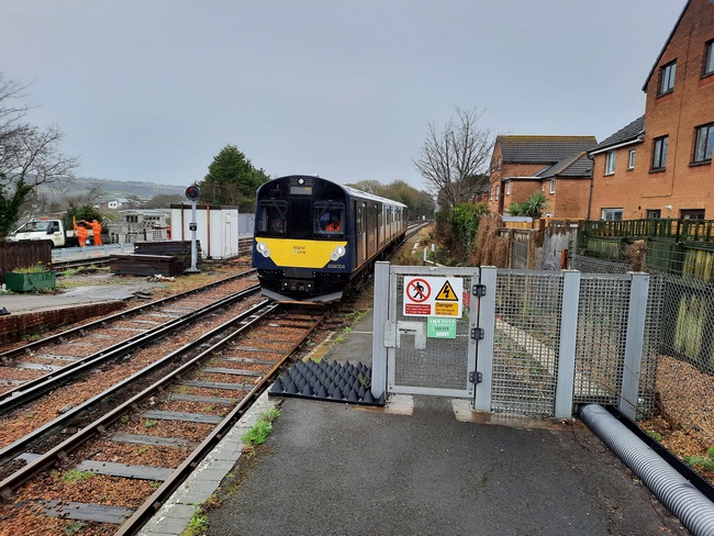
Below - Looking over the fence off the northbound platform the former platform for the Newport branch can be seen, it even still has track in it as it is now a permanent way yard.

Below - A Shanklin train arriving in the southbound platform. The permanent way yard at the former platform for the branch can be seen on the left, the line branched off where the trees can be seen behind the train.
From here I continued my tour of the island's disused railways, looking next at the line down the east coast to Shanklin which previously continued to Ventnor.
No comments:
Post a Comment