Starting Point - Langley Mill station. Finishing Point - Site of Underwood Colliery. Distance - 3.6 Miles.
Since my visit the Brinsley Headstocks have been dismantled.
Google Map (Langley Mill to Eastwood)
1881 Map (top left of map)
From Langley Mill station I walked to Eastwood following the A608. The road crosses over the Erewash Canal at Langley Mill Lock where the Great Northern Basin marks the point where it once met the Nottingham Canal. The abandoned Nottingham Canal featured on a previous walk.
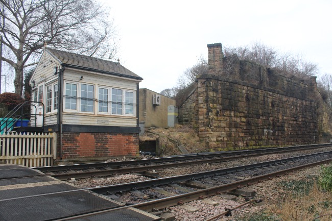
Langley Mill station is on the former Midland Railway route, the village also had a station on the Great Northern Railway which it shared with the nearby village of Eastwood. The former GNR route is now occupied by the A610. Where the A610 is crossed by the roundabout of the junction with the A608 is just to the south of the former Eastwood and Langley Mill station, all trace of which has been obliterated by the construction of the road.
Eastwood's most famous resident (it's not Clint) was D.H.Lawrence. The writer's birthplace is now a museum on the corner of Victoria Street and Scargill Street. Lawrence was the son of a miner and inspirations from Eastwood appear in many of his works.
Below - The D.H.Lawrence Birthplace Museum. Lawrance's birthplace was actually in a the flat above the old shop on the left, a plaque above the door marks the spot.

Returning to the corner of Nottingham Road and the A608 the Sun Inn also has an interesting history. It is claimed that the Midland Railway was founded here when a group of local mine owners met here in 1832 and decided to build a railway from Pinxton to Leicester to better transport their coal. Pinxton is just off the line through Langley Mill on the now freight only line to Kirkby in Ashfield. The Midland Railway was formed by the amalgamation of several railways so do doubt other pubs could make similar claims.
Below - The Sun Inn.

Google Maps (Sun Inn to Brinsley Headstocks)
From the Sun Inn I headed north on Mansfield Road (still the A608) towards Brinsley and the mine where D.H.Lawrence's father worked.
The railway that served the mine at Brinsley left the Midland route to the north of Langley Mill station. A short section of the trackbed survives between the junction and Cromford Road but this is not accessible. East of here industrial units occupy the former route.
After a junction with the Great Northern line and the line serving Plumptre Colliery (where the former railway route now forms the northern boundary of an Amazon warehouse) the line split with one branch heading east to Moorgreen Colliery and Watnall where it met another Midland line. Another branch headed north to mines at Brinsley and Underwood.
Below - Site of the Watnall line crossing Mansfield Road an abutment survives on the east side of the road.

The line towards Brinsley ran alongside Mansfield Road, the trackbed now reclaimed by the adjoining fields.
Below - The former Methodist Church shown on the old map.

A small park has been established at the Brinsley Colliery site. More about the park can be found on the Brinsley Headstocks website which includes details about the history of the site.
Close to the entrance to the park a derelict house can be seen to the east of the site, this was actually the home of D.H.Lawrence's Aunt Polly. His uncle had been killed in an accident at the mine before Lawrence was born however the stories told by family members formed the inspiration for the play The Widowing of Mrs Holroyd.
Below - The cottage near the mine once occupied by Lawrance's widowed aunt, the land in the foreground was occupied by sidings for Brinsley Colliery and the line onward to Underwood Colliery.

Below - The main focal point of the park are the Brinsley Headstocks. Built to an unusual tandem design the structure was second hand when installed in 1872 to extend the mine to a deeper seam. They were used until 1934 when the pit became just an access to the adjoining Moorgreen Colliery. The headstocks were removed in 1970 to move to a museum but were returned to the site to form a focal point of the park in 1991.

Below - To the east of the headstocks the railway line that continued north to Underwood Colliery is now a footpath.

Below - A footpath crossing under the former railway.

Open Street Map
The maps don't show the path along the railway leading out to Cordy Lane but usefully it does just before it joins the past heading east to Willey Lane. Beyond here the trackbed runs at the back of properties on Cordy Lane and is not accessible. On satellite images on Google Maps the course of the line can be seen curving around the fishing lake up to the crossing on Cordy Lane, also the site of the branch to Willeylane Colliery which was already closed on the 1880 map can be seen.
The trackbed can be rejoined after it crossed Cordy Lane as a footpath that runs through the site of Underwood Colliery up to where the footpath to Main Street in Underwood (which can be seen on the old maps) heads off to the north east.
Below - The footpath along the trackbed looking from the former crossing on Cordy Lane towards Underwood Colliery.

Below - A waste tip alongside the line.

Below - A bit of concrete retaining wall, likely from a later phase of the mine when it was known as Selston Colliery. Similar retaining walls can be seen across the field that now occupies the colliery site.

From here I returned to Langley Mill station the way, with a call in at the Sun Inn for food and drink. I didn't establish any railway companies on this occasion.