Starting Point - Batley Station. Finishing Point - Site of Birstall Station. Distance 2.5 Miles.
The 2 mile branch line from Batley to Birstall opened in 1852, it closed to passengers in 1917 as a wartime economy measure but remained a goods only line after the war until complete closure in 1962. The Batley end of the line has been largely built on but a stretch of the trackbed through Wilton Park has survived as the Wilton Park Greenway. More about the line can be found on the Railway Ramblers Kirklees website.
Rail Map Online View
1907 Map (bottom right of map)
The trip starts at Batley station on the former London & North Western line from Leeds to Huddersfield and Manchester. Batley was once a large junction, not only with the Birstall branch but with a number of Great Northern Railway routes that ran parallel through Batley.
Batley
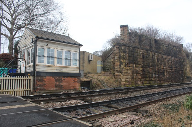
Below - The entrance to Batley station. Only the two LNWR platforms survive, industrial units occupy the site of the GNR platforms.

Turning right out of the station entrance and on to Upper Station Road the former goods yard can be seen.
Below - Former goods shed and offices next to Batley station.
Below - Looking back towards Batley station from the Soothill Lane bridge the former goods shed can be seen on the right. On the left side of the picture were the former GNR platforms.
Below - Looking north from Soothill Lane bridge at the former Batley Junction. The Birstall branch diverged on the left beyond the train. To the right of the surviving line the former GNR trackbed is in use as a construction site for the upgrade of the surviving line. The site of the GNR's Batley & Beeston line can be seen diverging on the right.

Turning left after crossing the railway on to Lady Ann Road. The Great Northern's Beeston & Batley Branch which connected to the mainline between Leeds and Doncaster crossed over Lady Ann Road on a bridge. The bridge has been removed but the stone abutments that carried it over a dog leg in the road survive.
Below - Abutments of the bridge that took the GNR Beeston & Batley Branch over Lady Ann Road.
Turning left on to Primrose Hill the road runs alongside the GNR's Batley Branch. The Batley Branch connected to Low Moor,
Bradford and the
Pudsey Loop.
Below - At Lady Ann crossing the GNR Batley Branch crossed over the LNWR route. The abutments of the bridge survive.
Below - At the crossing is Batley Signal Box, at least it was at the time of my visit before route upgrade work.
After crossing the line I turned left on to Rutland Road which leads on to Bridge Street. Bridge Street crossed over the Birstall branch on a bridge. Though the cutting has been filled in and houses built over the railway on either side the new houses have quite chunky garden walls that were the walls of the former railway bridge.
Below - The former railway bridge under Bridge Street.

West of Bridge Street Stockwell Drive has been built over the railway, I followed this and it's back Street at the end to the footpath from Bank Field Road to Grosvenor Road that appears on the old map and still exists.
Below - Remains of the footpath bridge.
Wayne Court connects to the the old foot path, the railway ran at the ends of the gardens at the south side of the road, I followed this to Batley Field Hill. The railway crossed here on a bridge but with redevelopment both sides of the road there is no trace of it. I followed Chinewood Avenue (which has been built on the former trackbed to Carlinghow Hill.
Carlinghow
The abutment on the west side of Carlinghow Hill survives. This was the site of Carlinghow station until it closed when passenger services were axed in 1917. From here the trackbed is intact as the Wilton Park Greenway.
Access to the path is off Transvaal Terrace where access to the station would have been.
Below - A culvert not shown on the old maps.
The wood shown as Carlinghow Shaw is now part of Wilton Park.
Below - Bridge under the railway leading in to the wood.
The path exits the park at Brookroyd Lane where the railway used to cross on a bridge, the embankment has been levelled and there is now no trace of the bridge, the path continues alongside Brookroyd View which has been built on the site of the railway.
Birstall
Below - Former footpath bridge over the former station throat.
Below - The site of Birstall station. Some of the fencing made of old railway sleepers can be seen where the roads ended at the station site.
Below - A bit of goods platform edging showing at the site of the cattle pens
Below - Heading on to the road called The Crossings much more the edge of the goods platform can be seen.
The station site continued up to Huddersfield with station buildings and a goods shed at the Huddersfield Road end, any trace of these have been lost with houses built between the new Church Road and Huddersfield Road.
This was the end of the branch, there had been proposals to carry on towards Bradford but with the construction of the GNR Batley Branch the LNWR scheme never happened.
I returned to Batley the same way with a stop at the Wilton Park Café next to the former railway for lunch.


No comments:
Post a Comment