A look around the Trafford Park Estate on foot and by tram in 2010 and 2022
In 1894 the Manchester Ship Canal opened giving ocean going ships access to the industrial city of Manchester. Land between the ship canal and the existing Bridgewater Canal was bought from the Trafford family and the Trafford Park Estate, the largest industrial estate in Europe, was established on the grounds of their estate.
While over a century of change has seen many of the big industrial concerns that existed on the estate disappear and warehouses replaced by modern industrial units the estate still survives as one of the largest industrial estates. Being a planned out industrial estate built in the Victorian era it was designed for good connections to the railway network and at one time many of its streets had railways running along both sides of the road. The last of these rail links survived in to the 21st Century, though now a lot of the goods traffic handled by rail is sent through the container terminals on the southern edge of the estate.
Below - Image found
on Flickr (click on the link to visit on the Flickr site and zoom in). The container terminals occupy the land shown as sidings along the curve of the Bridgewater canal at the bottom of the map. The lines radiating out to the various factories and warehouses have been removed, though some remnants can be seen.
More information about Trafford Park can be found in the Wikipedia article.
The extensive railway system also has its own Wikipedia article with a diagrammatic map of the system. It also mentions the gas powered tram that was operated on the system in order to move people round the large distances the site covered. Today trams once again run where some of the original tracks once ran as an extension to Manchester's Metrolink system now serves the Trafford Park retail park.
I have visited the Trafford Park Estate on two occasions, once in 2010 when I had been walking along the Bridgewater Canal and again in 2022 when I travelled on the new Metrolink route and visited some of the remains of the Barton Dock Branch, which had in fact still been in operation on my previous visit. I start with pictures from my 2010 visit.
Google Map
1934 Map
Below - Looking along the Bridgewater Canal from the Trafford Road bridge. The Old Trafford football ground can be seen on the left. On the right is the Victoria Warehouse which survives as a music venue.
Below - At the corner of Trafford Road and Trafford Wharf Road (shown as Trafford Park Road on the old map) a sculpture known as Sky Hook Statue 1 has been erected. The building in the foreground is one of the banks shown on the old map.
Below - Looking west along the Victoria Warehouse from the Trafford Road end. The headshunt at the end of the sidings for the warehouse shown on the old map can still be seen.
Below - Looking East along the Victoria Warehouse, the crossover of sidings shown in the old map can still be seen
Below - Looking west the rails fan out in to the next block of warehouses.
Below - Further along Trafford Wharf/Park Road is another large block of warehousing.
Below - The swing bridge on Trafford Road survives, though has not swung for some time and another bridge has been built parallel to it. The former bridge control cabin survives.
Where Fraser Place meets the Bridgewater Canal one of the rail links in to the Trafford Estate branched off from Trafford Park Sidings and crossed the Bridgewater Canal on a bridge. This can be seen on the left hand side of the map alongside the Varnish Works. The land of the former Varnish Works in the triangle between the railway and the canal is now a waste depot.
Below - The fenced off bridge over the Bridgewater Canal. The sign indicates that reversing moves across the road had a maximum speed of 5 mph.
Below - The line crossed Europa Gate next to the Europa Circular roundabout off Europa Way. Europa Way is a modern dual carriageway road built to the east of First Avenue on part of the former Ford factory site, vacated when Ford moved to Dagenham. The first shot is looking north towards the level crossing.
Below - Looking south across the crossing on Europa Gate.
Below - A branch along John Gilbert Way (formerly part of Westinghouse Road, named after the well known firm that once had one of the biggest factories on the estate) heading to the right diverged from the line to Cargill's factory on the Ship Canal (formerly the Corn Products Works) to the left.
Below - The line along John Gilbert Way. In the years since the lines have been removed and the businesses extended across the trackbed with just sections of rails embedded in side roads surviving here and across much of the Trafford Estate.
Below - The end of the lines along John Gilbert Way close to where it reached Wharfside Way. The warehouses in the background have since been demolished.
Returning to Europa Way the line to Cargill's ran along the east side of the road and crossed through the middle of Village Circular roundabout to access Trafford Park Road. The line ran from the south of the roundabout to the north west, the new tram line now crosses through the same roundabout but from the west to the north.
Below - Looking south from the centre of the roundabout.
Below - Looking north from Europa Way as the line crossed the roundabout.
Below - Looking south from Trafford Park Road as the line crosses the Village Circular roundabout.
Below - The line ran along the south side of Trafford Park Road, again the line has since been lifted and the businesses along the road have extended across the trackbed. Just rails that were embedded in side roads can be seen here today.
Below - A view looking west from the crossing on Third Avenue, the former rail connection in to Avenue Works (Chemicals) can be seen.
Below - I followed the line towards Cargill's as far as just beyond the crossing on Third Avenue. This view is looking south east, Third Avenue can be seen crossing the line just beyond the point for the rail connection to Avenue Works.
Below - At the corner of Elevator Road and Trafford Wharf Road stands the former Rank Hovis, now Whitworth Bros Mill. This was once served by the railway system. Back in 2010 a sign still warned of train movements within the estate.
Fast forward to 2022 and the lines of the Metrolink tram now run along Trafford Wharf Road at this point. The Trafford Park line diverges from the Eccles / Media City lines at Pomona, the narrow point between the Ship Canal and Bridgewater Canal once occupied by the rail lines serving the estate. The tramline heads south on Warren Bruce Road, a road built after the old maps around the site of the Trafford Wharf Warehouses.
Below - The Manchester Metrolink line running alongside Warren Bruce Road. A turnback siding is provided here to facilitate running additional trams for games at the nearby Old Trafford stadium.
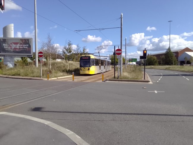
Below - Looking east as the tram crosses the Village Circle roundabout.
Below - From the Village stop on the tram the Trafford Park Hotel can be seen. At the time this was abandoned and boarded up.
1939 Map bottom right corner of map (yes, there's nothing there)
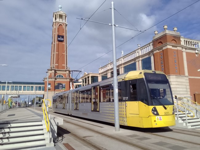
Below - Barton Dock Road stop and the Trafford Centre.
Below - The Trafford Centre terminus of the tram line.
East of the Trafford Centre a number of car showrooms have been built along Barton Dock Road on the site of the Barton Dock Terminal. This was the last part of Trafford Park's internal railway system to still be in operation, closing in 2014. Due to weight limits on the line trains would be split at Trafford Park Sidings and a shunter would take the train along the branch that ran alongside Barton Dock Road in a number of trips. Sadly I never photographed this line in operation.
From the Barton Dock Road tram stop I walked to St Modwen Road, here a footpath crossed the line.
Below - Site of the foot crossing, the steps up from St Modwen Road can be seen on the left along with the post for the warning signs, the track has been removed but the ballast of the former line stretches for some distance in both directions.
I returned to Barton Dock Road. The railway joined the south side of the road close to the junction with Brightgate Way.
Below - Another sign warning of trains on the internal railway system that existed in the estate.
Below - Looking west the trackbed of the line from Barton Dock Terminal meets Barton Dock Road.
Below - As seen elsewhere, rails are still in place where the line crossed side roads. This is also true on the north side of the road as another line which closed earlier once served businesses on the north side of the road too.
Below - A mile post at the side of the trackbed.
Below - A sign at the side of the trackbed showing that this was part of the Manchester Ship Canal's railway system.
Below - The Kellog's factory and the railway crossing Park Road at the junction with Barton Dock Road. The bridge crossed over the lines that ran along both sides of Barton Dock Road.
Below - The stub of the line that once served the north side of Barton Dock Road.
Below - Under the bridge between the Kellog's factory and warehouse the shed that housed the shunters for the Barton Dock branch can still be seen. A fence has been erected across the trackbed, the line continued on an embankment crossing Moss Road and the Bridgewater Canal to enter Trafford Park sidings.
From here I continued back to the Village tram stop for a tram back in to Manchester.


No comments:
Post a Comment