Starting Point - Colne Station. Finishing Point - Lane House Terminus, Trawden. Distance - 2.9 Miles.

Above - G.F.Milnes built car No 4 on the Colne & Trawden Light Railway in the early 1900s (photo Wikipedia)
The Colne and Trawden Light Railway Co operated electric trams between Colne and Trawden from 1903 and 1934. Despite so many years since the tramway closed there are surviving traces of the route between the eastern edge of Colne on Keighley Road where it left the branch to Laneshawbridge and the terminus at Lanehouse in Trawden.
From Colne station I walked to the corner of Keighley Road (A6068) and Cotton Tree Lane (B6250). This was once the site of the junction and tram depot.
More details about the history of the tramway can be found on the Wikipedia page.
The next street along heading away from Colne, Standroyd Road is built on what was the start of the first reserved track section of the Trawden Route. At the end of Standroyd Road a footpath continues along the former tramway. The earthworks such as the embankments shown in the old maps are still evident.
Below - Embankment of the former reserved track between Standroyd Road and Winewall Road.

The reserved section emerges on to Winewall Road alongside the former Standroyd Mill. The mill has been expanded over the years and the site remains in industrial use, though as a horticultural site rather than a cotton mill. At the side of the mill the site of the team rails can be seen in the stone setts of the roadway. The system was built to 4ft gauge so is noticeably narrower than the standard 4ft 8 1/2in gauge.
Below - Evidence of the former tramway just off Winewall Road.

The former tramway follows Trawden Road, which becomes Skipton Road closer to Trawden. As this is now the B6250 the tramway will have been tarmacked over many times since it closed (though like many tramways I expect bits will appear when the road is dug up for roadworks.) The next remnant of the old tramway is next to the Trawden Arms (The Rock Hotel on the old map).
Below - Next to the modern housing on Beckside Close I noticed this memorial dedicated to the local councillors in 1895. Of course that pre-dates the construction of the tramway along the road but was probably part of an upgrade to the road that made the tramway possible. The road ran alongside Trawden Brook and required a couple of bridges. Beckside Close occupies part of the site of Winewall Mill, another cotton mill.

Having left Church Road at the Rock Hotel the tramway ran on a reserved track with footpath, the track was laid in stone setts which survive with the filled in course of the rails evident.
Below - Former passing place next to the Trawden Arms.

White Lee Avenue has been built alongside the tram route. Where it curves to the east the tram route forms a footpath to Lanehouse with the stone setts still in place most of the way to the former tram terminus.
Below - The former tramway alongside White Lee Avenue.

Below - Former tram route at the back of White Lee Avenue.

Below - Former tramway just south of White Lee Avenue.

Below - Approaching the former terminus at Lane House Lane (or just Lanehouse on the modern maps) a short section of rail is still in situ just before the road junction.
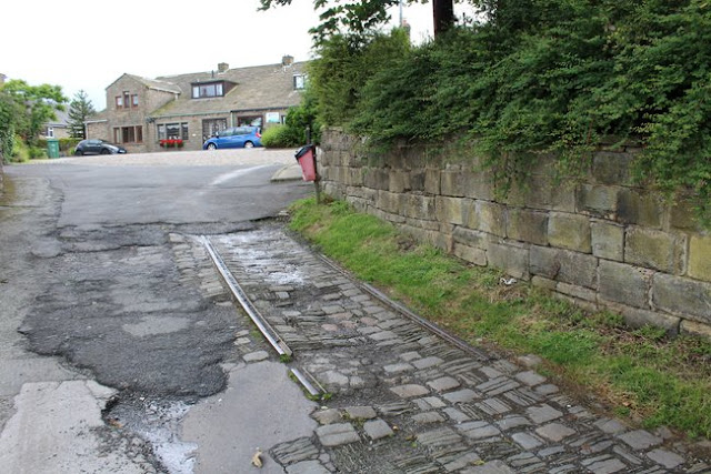
The tramway continued a short distance on to Lane House Lane, though this has since been tarmacked over. At the junction between Lanehouse and the former tramway is a bus turning circle with the stop known as Lane House Terminus and served by buses from Burnley.
Below - The end of the tramway remains near the terminus on Lanehouse.

No comments:
Post a Comment