Starting Point - Garforth Station. Round trip to Aberford. Distance - 6.5 Miles
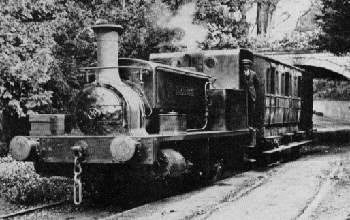
Above - One of the Manning Wardle locos passing the Light Arch (Photo from the LNER Encyclopedia)
The Gascoigne family owned several coal mines in the Garforth area but had difficulties transporting the coal mined in the area. They were shareholders in the Leeds & Selby Railway constructed in the 1830s and around the same time built a light railway to the village of Aberford serving a few of their mines on the way. This was horse worked with rope haulage on the steepest section until adapted for steam locomotive use in the 1870s. The Gascoignes sold the pits and the railway in 1920 after which the railway closed in 1924 and the last of the pits in 1930. Remarkably after so long since closure most of the trackbed survives as a footpath, known as the Fly Line after the nickname for the railway.
Even from the early days of horse haulage there was a passenger service using a primitive carriage attached to the rear of coal trains along with a dandy cart for the horse that would haul the wagons back up the line. When the line used locomotives the passenger stock was considerably improved with second hand four wheel coaches.
Much more about the history of the railway can be found on the Parlington Hall website and LNER Encyclopedia.
On the old maps the connection between the main line and the Aberford Railway together with the sidings and Sisters Pit is spread across two pages. The mainline connection can be seen at the top of this page -
With details further north on this page -
The site of the sidings and Sisters Pit are now occupied by a Tesco Supermarket. Part of the trackbed is occupied by other retail units (including a pub called The Fly Line) and industrial units. The former trackbed is accessed from Ash Lane. Industrial units occupy the site of Isabella Pit. One of the buildings from the former mine survives.
Below - Old building from Isabella Pit

Beyond the industrial units at the site of Isabella Pit the road becomes a path along the trackbed.
Below - Trackbed near Garforth.

Below - Spoil tips from Isabella Pit in Hawks Nest Wood.

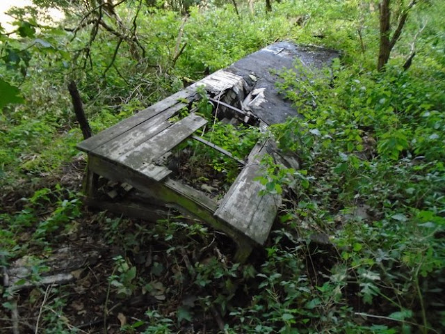
In Hawks Nest Wood a farm worker once lived in an old railway carriage alongside the railway line. A little bit of the remains of the carriage could be seen to the left of the path. The collestory roof is largely intact but such is the state of the remains that this seems to be resting on the floor.
Below - Remains of railway carriage at Hawks Nest Wood.

At the site of Elizabeth Pit the M1 Motorway now crosses over the former railway route, a subway has been built for the footpath.
Lilly Pit Cottage survives and in the trees alongside the path the heaps of spoil from the mine can be seen.
Below - Cottage from Lilly Pit.

Below - One of the line's Manning Wardle locos shunts a coach out of a carriage shed in this photo from the LNER Encyclopidia.

Below - The trackbed north of Lilly Pit.


1893 Map (bottom right of page)
As the trackbed curves to the right the path is a bit rough for an old railway trackbed, possibly a result of years of horse use and this stretch getting muddy in the shade of the trees.
The old map shows a old coal staith. Parlington Lane previously having served as a pack horse route for the coal before the railway was built.
The railway passed to the south of the Parlington Estate, the grand house of the Gascoigne family. Most of the hall is gone now, just part of a wing of it surviving. The Parlington Hall website gives a thorough history of the estate.
Below - Trackbed near the Parlington Estate

The trackbed meets Parlington Lane as both pass the former Gamekeepers house. The Gamekeepers house survives as a holiday cottage. A small gas works also used to turn coal from the Gascoigne pits in to gas for the estate here.
Below - The Gamekeeper's house.

Below - The retaining wall alongside Parlington Lane and the course of the railway.

Below - The Dark Arch. This tunnel was on the original packhorse route of Parlington Lane, not for any necessary of the landscape but to hide the coal traffic from the view of the hall.

Below - When the railway was built the tunnel was too low so the railway had to run around the back of it.

Below - A look back to the Dark Arch with the railway on the left.

Below - Inside the Dark Arch.

Below - The Light Arch is a much smaller structure that was adapted for the railway.


Below - Looking back to the Light Arch with some of the retaining walls.

Below - Former entrance to one of the quarries that lined this part of the route.


Below - Lodge House seen on the above map.

Continuing to the end of the former railway at Aberford the vacant triangle of land formerly occupied by the station and coal depot is still vacant.
Having reached the end of the line I started heading back towards Garforth but took a little detour to look at a couple of interesting features on the Parlington Estate.
A footpath heads north through the field close to the old quarries. Turning left on to the main road in to the estate brings us to the Parlington Arch, a triumphal arch built to celebrate the American victory in the war of independence. This does seem like it could have been seen as an act of treason at the time. It is said that the Prince Regent was due to attend a luncheon at the hall but left when he saw the inscription on the arch.
Below - The Parlington Arch.

Just before the arch on the north side of the road where what looked to be the remains of garages, complete with a ramp for examining beneath a vehicle. Unfortunately I couldn't find this feature on the old maps.


I had hoped I might be able to walk through part of the grounds, perhaps see a view of the remaining fragment of the hall and look for the ice houses shown on the old maps. A Private Property sign made it clear that this way was out of bounds though so I returned to the railway trackbed where I had left it and continued back to Garforth.
No comments:
Post a Comment