Starting Point - Frome Station. Finishing Point - Site of Welton and Midsomer Norton Station. Distance - 11.3 Miles
Google Map
Radstock once sat on a Great Western line between Bristol and Frome as well as the Somerset and Dorset route to Bath Green Park. The area was rich in coal mining and the town also housed a couple of important wagon works. While the GWR route to Bristol closed before the Beeching cuts in 1959 and Somerset and Dorset closed in 1966, the Frome to Radstock section remained open to freight, serving the mining industry until 1973 and the Marcroft wagonworks until 1988. The route now forms part of the Colliers Way foot and cycle path. Unusually for a path along a former railway line, very little of the line was actually lifted and for most of the route the path runs alongside the single overgrown track that remains from its later days as a branch to serve the wagonworks. The sight of a track still in situ most of the way from Frome to Radstock has also lead to calls for the route to be re-opened for passenger service. More information about the route can be found on the North Somerset Railway website.
1950 Map
The path along the trackbed doesn't begin until just north of the village of Great Elm north west of Frome. The route from here until the junction north of Frome station is still in use by stone trains from Whatley Quarry. The link to Whatley Quarry was a relatively modern addition to the railway network added by British Railways. Previously access was by the Vallis Quarry Tramway which had been originally built as a narrow gauge line and was not up to handling the large volumes of stone carried in modern wagons. A slight detour from the roads taking us from Frome to Great Elm allowed us to check out some remnants of the Vallis Quarry Tramway on our way to the GWR route.
We followed the roads out of Frome to the roundabout on Vallis Road and Wallington Way, here a footpath known as the East Mendip Way and shown as Leys Road on the old map connects to Great Elm. The path descends quite steeply in to the Vallis Vale and follows the same route shown on the old map following the river north. After crossing the river on the footbridge shown on the old map and turning left the footbridge that once carried a branch of the tramway along the opposite side of the railway can be seen.
Below - Former tramway bridge in Vallis Quarry
Following the former tramway to Great Elm we occasionally see other remnants of the local stone industry such as the lime kilns shown on the old map.
Below - Old lime kiln in Vallis Quarry

Below - Concrete sleepers in Vallis Quarry
Below - Footbridge crossing the former Vallis Quarry Tramway.
Below - BR built line to Whatley Quarry crossing the earlier Vallis Quarry tramway.
The East Mendip Way joins Elm Lane at Great Elm, a short walk to where the Colliers Way along the Great Western trackbed can be joined.
1887 Map
The cycle track follows the foot of the embankment for a short stretch but steps have been provided up to the track level where the ballast was still covering the trackbed.
Below - Start of the Colliers Way
Below - Ballast still in place close to the junction with the Whatley Quarry branch.
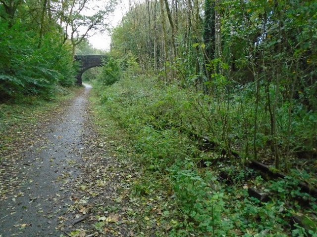
As the line goes from embankment to cutting the path runs alongside the cutting to the south of the line, through the trees the rails can be seen still in place and quite overgrown.
Below - The path running alongside the overgrown railway line as it does for much of the journey.
1904 Map
Below - Conduit Bridge

1904 Map
Below - Jericho bridge
Between Jericho Bridge and the site of Mells Road Station there is evidence of the sidings that were situated there with pointwork amongst the overgrown track alongside the path. More remarkably there are the remains of a brake van still stood on one of the sidings.
Below - Old brake van near the site of Mells Road station.
The story behind the wagon is that it was used to move stone wagons between the nearby quarries and the Marcroft Wagon Works in Radstock. The local quarries had a number of second hand wagons that had previously been used on iron ore trains, these were large box shaped tipper wagons that were unloaded by turning them through 180 degrees. They had a special type of buckeye coupling between the wagons (though standard couplings on each end of the rake of wagons to couple to the loco) that allowed the wagons to be tipped without having to uncouple them from the train. This meant they had to use an adapted brake van with a buckeye coupling at one end and what was then the more normal three link coupling on the other if individual wagons or a small number of the wagons needed to go to the works.
Below - The buckeye coupling on the adapted wagon used to move tipper wagons to the works in Radstock.
The wagon seems to have just been abandoned when traffic to the works stopped in 1988. In fact it ended up owned by a preservation group that had been working to reopen the line as a heritage railway. Although stock from that scheme has moved to other heritage lines it would be difficult to remove the wagon from where it stands with the vegetation that has grown up around it.
Below - Also close to the site of Mells Road Station was a lineside hut.
As the path passes through the site of Mells Road station a concrete yard now occupies the land on the south (left) side of the railway and with it the site of the Newbury Railway that branched off here to local collieries and Vobster Quarry. There is nothing to be seen of the old station itself, though there is a Station House on Hatchet Hill, though this is not shown on the old maps presumably this was a station master's house.
Below - What appears to be a length of old broad gauge rail (this line was first built to broad gauge) once in use as a fence post. The other side of the fence would have been the access road to the goods shed from Hatchet Hill.
Below - The steep stone lined cutting west of Mells Road station with the bridge carrying Hatchet Hill from which the station would be accessed.
Below - The next bridge over the railway close to Batch Farm.
1904 Map
Below - Bridge carrying the railway over the B3139
Below - Bridge carrying the footpath to Kilmersdon over the railway.
The line passes the village Kilmersdon, though remarkably there was no station here despite the reasonable sized village that can be seen on the left, there was certainly more here than at Mells Road.
The line curves north and follows a fairly straight course towards Radstock.
Approaching Radstock a couple of connecting colliery lines can be seen on the old map, in the woods on either side of the line at this point seem to follow the course of these lines. The Radstock Wagon Works shown on the old map is the works that became part of wagon maker Marcroft that had sites around the country and was the final source of rail traffic on this route. Modern housing has been built around the railway as it reaches Radstock and Radstock has expanded outward. A few sights of the sidings that stood here can be seen.
Below - Old yard lamp on the approach to Radstock.
Below - The engine shed, often referred to as the Brunel Shed as it dates back to broad gauge days. It is being restored for community use.
Below - Another yard lamp as the trackbed of lines in to Ludlow's Colliery disappears in to the trees.
Below - Some of the buildings of Ludlow's Colliery survive, with rails still in place.
Where the line passed through the middle of Radstock has been largely built on. Great Western Court occupies the former station site. There were two stations in Radstock, one for the GWR and one for the S&D and these were just yards apart.
Beyond Radstock the footpath and cycle route continues as the Norton - Radstock Greenway. Where this route leaves the A367 is actually the former S&D route, at the level crossing in the centre of the above shot to be precise. A chord was built from the S&D to the GWR route here where the two ran so close together when the S&D closed so that a colliery east of Radstock would still be rail connected after the S&D closed. The path descends to the GWR route which is occupied by a children's play park and a car park. It then follows the GWR route to Midsomer Norton.
Below - The "Five Arches" bridge where the Somerset & Dorset line crossed over the top of the GWR route.
Below - West of the Five Arches there is still a signal post in place.
The two communities of Welton and Midsomer Norton have become quite merged now but the old map shows that they were separate villages. The GWR station was known as Welton and the S&D station was known as Midsomer Norton, however the GWR renamed Welton as Welton and Midsomer Norton and eventually Midsomer Norton and Welton. The S&D also renamed their station Midsomer Norton and Welton, it's easy to see how that could have been confusing. After nationalisation the S&D station was named Midsomer Norton South.
Today the path crosses a modern bridge over Station Road, there is nothing to be seen of the old Welton station on the west side of that bridge.
The Norton - Radstock Greenway continues to Northmead Road, west of here after a short section of embankment the trackbed has been ploughed in to the farmers fields. We walked across Midsomer Norton to the former Somerset & Dorset station and the start of another railway walk.


No comments:
Post a Comment