BROWSE JOURNEYS BY MAP VIEW

Saturday 20 November 2021

South Tynedale Railway


Starting Point - Haltwhistle Station. Finishing Point - Slaggyford Station. Distance - 8.6 miles.

Google Map

The branch line from Haltwhistle to Alston was built in the 1850s and originally intended to continue east to Nenthead. The route was primarily built for its mineral traffic particularly coal which in this region was ideally placed to serve the iron and steel industry of Cumbria and the North East alongside nearby limestone and iron ore workings. The nearby Brampton Railway, a system of colliery lines that dated back to early wooden wagonways built an extension to meet the Alston line in Lambley. 

A century later there was a decline in the local coal industry of the area. The newly nationalised National Coal Board were looking to modernise the industry and the mines in this region largely consisted of small mines that were prone to flooding. From the 1950s the line just saw a diesel unit passenger service from Haltwhistle and the writing was on the wall. It was recommended for closure in the Beeching report but was reprieved due to the poor local roads that were regularly blocked with snow in winter and the lack of bus services. Closure came in 1976 once the road situation had been improved.

On closure of the line a group formed to preserve it and has operated narrow gauge trains from the Alston end since 1983, gradually extending as far as Slaggyford.

More about the history of the line can be read on the Wikipedia article.

While it would possibly be an interesting trip to walk to Slaggyford, take a train to Alston on the South Tynedale Railway and return by bus my visit was on a day the railway wasn't operating. Instead I took my folding bike to Haltwhistle and cycled to Slaggyford and back, it being a bit far to walk it in both directions. I have previously ridden on the train a few times.

1921 Map

Haltwhistle station has more period character than some heritage railway stations with most of its original buildings remaining including a unique elevated signal box and the water tower. Part of the old goods yard survives as an engineer's siding for stabling track machines.


Below - A Carlisle bound train. At the back of the platform to the right of the picture there was once another platform face for the Alston branch services.

The Alston branch is a cycle route as far as Slaggyford, though parts of it designated "cycle track" denoting that it is not all tarmacked (in fact at Lambley it is necessary to carry the bike up and down several steps). The route is accessed just south of the station.
Below - The old map above shows a siding terminating alongside the branch line, the buffer stop of this is still in situ.


Below - The Alston Arches viaduct.


After the viaduct there is a short detour where the Haltwhistle bypass has cut through the formation but the trackbed is regained off Plenmeller Road just across the bypass. From the 1920s to 1940s a simple platform halt was provided here. An industrial site now occupied the former colliery site to the left of the railway.

1896 Map

Below - A couple of surviving bridges as the line passes Broom Houses.


1896 Map

Below - The first proper station was Featherstone Park, the platform survives and the station master's house is now a private residence. The former goods yard is now a car park for people using the path.


Below - The station shortly before closure and by then an unstaffed halt. (By Johnragla - Own work, CC BY-SA 3.0, https://commons.wikimedia.org/w/index.php?curid=23898104)


Below - Footpath bridge crossing the railway line
.


1896 Map

As we get towards Coanwood and Lambley we pass the most popular part of the trail for reasons that will be clear. Another car park is provided just north of Coanwood on the site of the sidings for Featherstone Colliery. A retaining wall survives at the back of this and coal was loaded from an incline plain from the mine at the top of the wall. The incline plain can be seen on the Google satellite maps.
Below - Information board provided for visitors to the trail at the Coanwood car park.


Below - Surviving buffer stop that was at the north end of the loop through Coanwood station.


Below - Surviving platform and base of signal box at the site of Coanwood station. The station master's house is now a private residence in the background.


Below - Remains of the goods platform to the south of the station.


Below - It can just be made out through the vegetation where the lines in to Coanwood Colliery curved off, this mine was shown as disused on the above 1896 map.

1921 Map

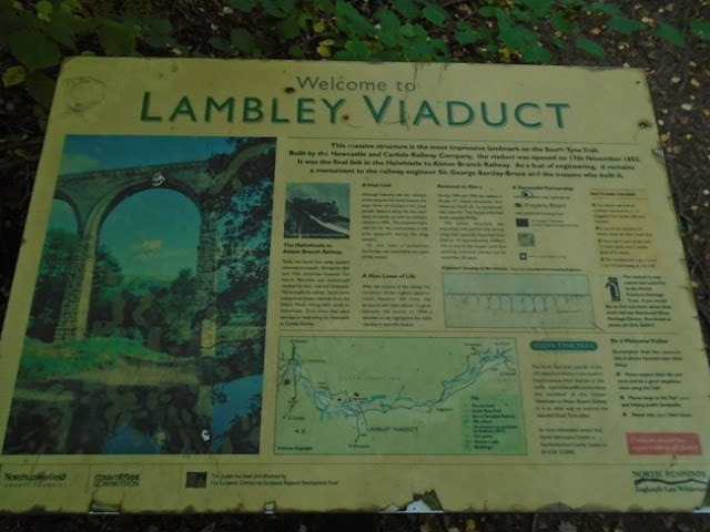
To the north of Lambley Viaduct another car park is provided and an information board (below).


Lambley Viaduct is an impressive site. A slender structure built for single track high above the valley it almost feels like flying to ride over it on a bike.


Unfortunately the station site is privately occupied and is fenced off. The path descends to the foot of the viaduct via several steps, though this does offer a good view of the viaduct from ground level. Also when leaving the trackbed the embankment of the Brampton Railway can be seen through the vegetation.


Below - The former Lambley station seen from the footpath alongside the privately owned station site.


Below - Lambley station prior to closure (By Johnragla - Own work, CC BY-SA 3.0, https://commons.wikimedia.org/w/index.php?curid=23898104)

1921 Map

Below - Viaduct carrying the former line over Glendue Burn.

1921 Map

Below - Bridge over the line at Softley

1922 Map

Below - Road bridge over the line, since strengthened for heavier road traffic.


Below - Viaduct over Knar Burn.


Below - Bridge over the line just north of Slaggyford station site.

1896 Map

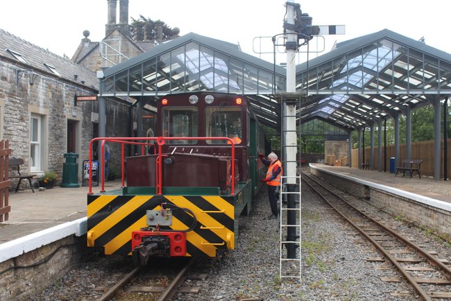
Below - Slaggyford station, currently the northern terminus of the narrow gauge South Tynedale Railway.


I shall continue the journey to Alston by means of photographs taken on previous visits to the STR.

Below - The loco running round at the then newly opened Lintley Halt in 2012.


Below - South Tynedale Railway steam locos at Alston at the site of the turntable during a 2012 gala for the opening of the Lintley extension.


Below - Clayton battery loco on a Slaggyford train in 2019. Though the station roof is modern the station did originally have a roof.


Below - Alston station prior to closure by BR. (By Johnragla - Own work, CC BY-SA 3.0, https://commons.wikimedia.org/w/index.php?curid=23898102)


No comments:

Post a Comment