Starting Point - Northumberland Park station. Finishing Point - Percy Main station. Distance - 6.2 Miles.

This walk coincided with a gala at the Stephenson Railway museum. The museum operates trains on a section of the Blyth and Tyne Railway between Middle Engine Lane and Pelaw. Originally the line extended further in both directions, north of Northumberland Park it connected to the line still in use by freight (and at the time of my visit about to be upgraded for passenger use again). South of Pelaw it continued in to the docks on the Tyne. The main business of the line was to take coal from the many collieries in the area to the docks for export or shipping to London. The line dates back to early wooden waggonways built for that purpose and at one time a few parallel waggonways of different collieries followed a similar course to the Tyne docks. More detail about the complex history of the route can be found on the Wikipedia article.
Below - My starting point was Northumberland Park station, like a number of old Newcastle suburban lines this was converted to a Metro service in the early 1980s.

The freight line that utilises a surviving part of the Blyth and Tyne route runs alongside the Metro at this point before curving north just past the station. The "Waggonways" trail that follows the closed section of route can be joined where it crosses Earsdon Road to the east of the station.
Below - The bridge that carried the route over the line now in use by the Metro.

The route can be followed north up to the point it met the section of line still in use today at the former Earsdon Junction.
Below - The site of Earsdon Junction.

Heading back south to Earsdon Road I continued south on the route. On the left hand side I passed the site of Shiremoor Colliery.
Below - An information board at the site of the mine, also known as Bluebell Pit after the nearby pub which still stands. Though graffitied only the photos were covered at the time.

Below - Passing the site of Shiremoor Colliery in the trees on the right of the photo which was taken looking north.

Below - The bridge carrying New York Road over the line and remains of an earlier bridge. This was the site of Prospect Hill station but only for 23 years as it closed in 1864 with passenger traffic by then taking the Newcastle, Tynemouth and Newcastle circular route that now forms part of the Metro network.

South of the bridge on the left was the site of Algernon Pit, now occupied by an industrial estate.
Below - Another information board at Middle Engine Lane about the Middle Engine the road got its name from. Many of the local lines were built before steam locomotive use became commonplace and had quite steep gradients which required the trains to be hauled by ropes with several winding engines dotted around the area.

Prior to the upgrade of suburban routes to a Metro system a testbed was set up on this line, the two prototype metro cars were based in a small shed at Middle Engine Lane and demonstrated on a stretch of line. That shed and line was later used to establish a heritage line with items moved from an earlier museum at Monkwearmouth station.
Below - A timetable for the short lived passenger service on this stretch of the Blyth and Tyne displayed in one of the heritage railway's coaches.

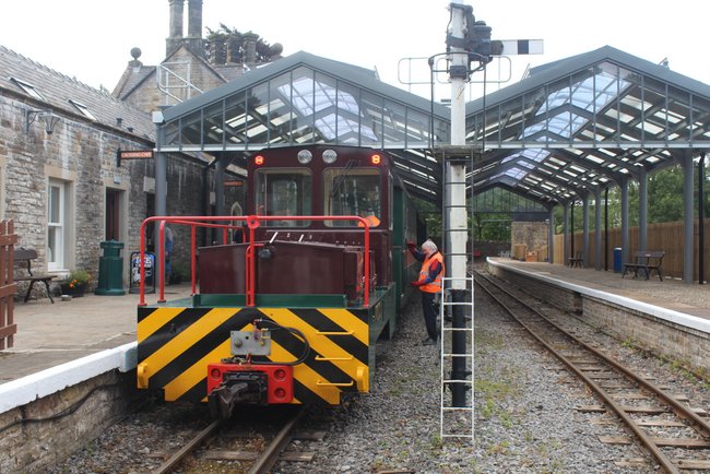
Below - The heritage railway on part of the line. As part of the gala a J27 visited, a type of loco regularly seen on the line. Here it shunts the demonstration freight train in the yard outside the museum at Middle Engine Lane.

Below - To access the shed the Metro testbed and later heritage railway passes over the Waggonways path using a bridge that previously carried the Rising Sun colliery line.

Below - The former Rising Sun Colliery line curving off, the route is now a path but is surrounded by modern development with little trace of the railway it once was or the mining industry it served.

Though there is now an operational heritage railway on the trackbed between Middle Engine Lane and Percy Main, that is not an obstacle to the Waggonways trail due to the way it follows a few parallel routes. In parts there are two or three paths as well as the railway. On parts where paths cross the north - south route it can be seen how there are a few distinct embankments of the various routes.
Below - Just south of Middle Engine Lane on the Waggonways path, the heritage railway is running alongside on the right.

Below - A National Coal Board Austerity loco that operated at Backworth Colliery which this line served passing on a passenger train to Percy Main.

North of Percy Main at Percy Main North Junction lines fanned out towards the various docks and quays on the Tyne. The heritage railway curves off to the west and passes under the former Newcastle, Tynemouth and Newcastle line that is now part of the Metro system to its own Percy Main station.
Below - The Former Percy Main North Junction where lines to the docks fanned out. The Waggonways path curves left while the heritage railway curves right.

Below - The line's Bagnall tank engine heading back to Middle Engine Lane.

Below - The J27 with the passenger train at Percy Main, the southern terminus of the heritage line. There was a station on this route between the former junction and the present station, this too closed in 1864. South of the station was the Percy Main engine shed, once home to several J27s. Beyond this the line once continued to Northumberland Dock.
The loco carries The Norseman, this was a boat train service that connected with the ferries to Sweden and continued long after local passenger services on the route had finished.

Below - The line's Bagnall tank runs round at Percy Main.

Below - The bridge carrying Walsend Road over the former line to Albert Edward Dock.

Beyond the above bridge the path takes a detour as a new road has been built through the area.
Below - This section of path follows the former Seatonburn Waggonway that ran to its own staiths on Northumberland Dock. It passes under the Newcastle, Tynemouth and Newcastle line which is now part of the Metro system, the modern Percy Main station is at the top of the bridge.

East of the former Seatonburn Waggonway another path through At John's Green follows the former route to Albert Edward Dock. Though the path still leads to the docks where the railway once delivered trains of coal, much of the last stretch of route on the approach to the docks has been redeveloped. A short stretch of path forming part of Cycle Route 72 passes under the A187 and alongside the road in to the docks, Coble Dene. Beyond this it follows a similar route to that taken by railway lines but the area has been landscaped.
Below - The former Albert Edward Dock, now the Royal Quays Marina and Cruise Terminal.

West of here was Northumberland Dock which was also served by lines fanning out from Percy Main North Junction. Most of the dock has been filled in, the former lock entrance at the eastern end of the dock can be seen on satellite maps but this in in an industrial site.
From the former dock complex I returned to Percy Main's Metro station for a train to Newcastle.