Starting Point - Newcastle Central Station. Finishing Point - Dunston Staiths. Distance 2.7 Miles
In this walk I explored some items of railway history around Gateshead. Once home to the North Eastern Railway's engine works and coal staiths on the River Tyne.
An obvious place to start as it was also my way of getting there from Newcastle Central station was the High Level Bridge. Built to a design by Robert Stephenson and opened in 1849, more can be read about the High Level Bridge on the Wikipedia article. Prior to this bridge opening Gateshead was as far north as the trains from London could run, passengers would have to transfer to ferries to cross the River Tyne. As well as the railway tracks on the top deck of the bridge the lower deck had a roadway, the toll charges for which were seen as a nice extra source of revenue. Footpaths were also provided and these can still be used to cross the Tyne on foot today.

A couple of terminus stations were built at Gateshead, first was the Newcastle and Carlisle Railway's Redheugh station in 1837, the riverside site of which can be seen in the above old map beneath the Redheugh Bridge even though it closed to passengers in 1850 shortly after the High Level Bridge opened. The Newcastle and Darlington opened a temporary station at Oakwellgate in 1839, replaced by a station at Greenesfield in 1844 which I'll come to later.
With the opening of the bridge Gateshead would be served by through trains to Newcastle. There is now a triangular junction on the approach to the bridge from Gateshead but at first the line came in from the east. Originally the main line from the south being the Leamside route through Washington. In 1868 approaches from the west were added and with the opening of the Ferryhill route from Durham in 1872 that became the direction from which main line trains from London would come. Platforms were built on the diagonal sides of the triangle, the other side of the triangle being for the freight trains that didn't need to cross to Newcastle. The stations were referred to as Gateshead West and Gateshead East, though they were connected and shared facilities so were effectively one station. In 1906 a much bigger bridge over the Tyne was built to the west to increase capacity in to Newcastle, the King Edward Bridge. The mainline trains then approached Newcastle from that bridge with just local trains approaching through Gateshead. Gateshead West closed in 1965 while Gateshead East continued to be served by local trains to South Shields and Sunderland until the Tyne and Wear Metro took over most of the local journeys in the 1980s. The Metro had a new underground station in Gateshead connected by its own bridge across the tyne to an underground station at Newcastle Central and on to suburban lines across the north of the tyne. Gateshead East station closed in 1981, though the Network Rail lines are still in place and are used by Northern Rail services to Sunderland, Hartlepool and Middlesborough but these pass through Gateshead without calling. More about the stations, and plenty of photos can be found on Disused Station's page about Gateshead East and Gateshead West.
Below - The Arch with two doorways (in to what is now a takeaway) is the former street entrance to Gateshead East Station. The metalwork of the bridge entrance can be seen further ahead and the other side of the triangle on which Gateshead West stood.

Below - The East side of the triangle and the freight only south side. Note the wide abutments on the bridge to the left for the platforms that it once carried.

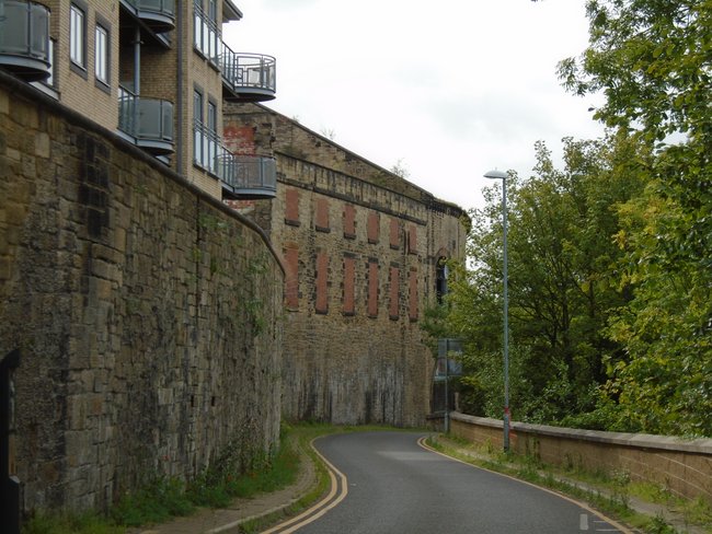
Below - The former access road off Hudson Street to Gateshead West station.

Alongside Gateshead West station to the west was the former locomotive works of the North Eastern Railway. The first building related to the works we see after crossing under the railway bridge are some former office buildings.

These buildings were adapted from buildings associated with the Greenesfield station and it's adjoining hotel that pre-dated the through platforms on the lines on to the High Level Bridge. The tracks in to the station came in from the east behind the buildings.

Below - Blue plaque dedicated to North Eastern CME Vincent Raven on the above building.

Below - Though many of the former works buildings have been demolished some of the buildings survive including this building on High Level Road

Below - The same building from the higher Fletcher Road (named after another NER engineer).


Below - One of the works buildings on Fletcher Road still in a derelict state but earmarked for development.

Below - Another view of the buildings along High Level Road from further west along the road.

Below - More old works buildings along Rabbit Banks Road


Below - The same buildings seen from the higher level of Worsdell (another NER engineer) Drive. These buildings are also yet to be adapted for new uses.


From Rabbit Banks Road the foot and cycle paths along the Tyne can be reached. After passing under the modern Redheugh Bridge which carries the A189 the abutment of the smaller original bridge can be seen. Around here was the site of the early station for trains to Carlisle and the ferry jetty mentioned earlier. There is nothing to see of these today.
At the site of Redheugh Junction a path goes off to the left, this follows the course of Tanfield line, I did this route as an earlier walk and details can be found here.
A short way further along the Tyne in the former Dunston Coal Staith. Said to be the largest wooden structure in Europe this was also built by the North Eastern Railway and opened in 1893. The staiths were used to load train loads of coal from collieries across the area straight on to sea going ships. The staiths were closed in 1980. In 1990 they were refurbished to form the backdrop to the Gateshead Garden Festival. In the years since they have been a target for arsonists. There is now a section of the staith missing. Dunston Staiths website explains more about the staiths and their history.


Below - Towards the land end of the staiths where there was a smaller lower level.

Below - Former railway bridge that took the North Eastern's lines along the Tyne across the River Team.

No comments:
Post a Comment