Starting Point - Northern Viaduct Trust car park, Kirkby Stephen. Round trip to Fell Lane, Kirkby Stephen. Distance - 6.5 Miles.
Continuing on the following day from my walk from Kirkby Stephen to Ravenstonedale on the former Tebay route, this time I headed east on the former Stainmore route. This section contains a couple of impressive viaducts and the trackbed is managed as a footpath and cycle trail by the Northern Viaduct Trust. More information can be found in their Exploring the Eden Viaducts walk leaflet.
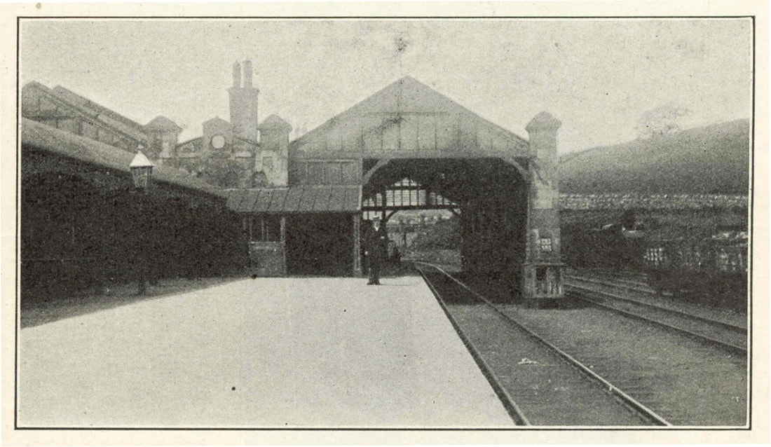
Below - An old image of Kirkby Stephen East station from the Stainmore Railway Co website
Below - The former Kirkby Stephen East station, now the home of the Stainmore Railway Co's museum.

The former goods yard and surviving goods shed are occupied by the Pennine View caravan park so a detour around these along Station Road is necessary to reach the car park for the trail.
This line was once part of the Stainmore route from Tenby and Penrith through to Bishop Auckland. Opened in 1861 and closed in 1962 before the Beeching cuts, this section survived a bit longer as it provided access to Hartley Quarry from Appleby where the line connected to the Settle and Carlisle line. Stone trains from the quarry continued until 1974 at which time the route was cut back to Warcop where it served an army base sporadically for the next 15 years. More can be read about the Stainmore Route on the Wikipedia article.
Below - Video on YouTube of a ride on the Stainmore Route.
The former bridge over the River Eden is no longer in situ so the path along the route begins to the east of the river. A car park is available for those wishing to visit by car. A short distance in to the walk and a surviving plate layers hut has information boards installed to provide an introduction to the route.
Below - A former plate layers hut now containing information displays about the route.

Below - The footpath bridge shown on the old map still in situ.

Below - The first of the viaducts we come to is Podgill Viaduct, a path to the foot of the viaduct gives views of the structure.

Below - View along the top of the viaduct.

Below - Note the seam underneath the arches where the viaduct was widened from single to double track.

Unfortunately Hartley Quarry is not shown on the above old map. Old quarries and lime kilns can be seen nearby, the needs of the steel industry in the first world war prompting these workings to be reopened.
Below - Former buffer stops at the headshunt of the line in to Hartley Quarry. This is part way up the cutting side on a higher level to prevent the risk of runaway wagons fouling the main line.

Below - A look along the former Hartley Quarry branch from where it met the main line.

Below - Brick hut where the line in to Hartley Quarry met the main line, also now containing information boards.

Below - Remains of Merrygill signal box along with remains of a wagon that must have had a mishap nearby.


Just after the short branch went off to Hartley Quarry is the next viaduct, Merrygill Viaduct. Having passed the source of freight in to the 1970s we are now on trackbed that had been closed since 1962.

At the far side of Merrygill Viaduct is the car park for the Northern Viaducts Trust, beyond here the trackbed is footpath rather than cycle route but is still walkable for a little more than the distance covered up to this point.
Below - Some track components still lying around near the car park for the walk.

Below - Looking along the trackbed beyond the Northern Viaducts Trust car park

Below - Giving an idea of the scenic route this once was with a look across the valley it followed.

Below - The tarmacked cycle route gives way to an unpaved footpath.

Below - Bridge over a farm access.

Below - The bit of engineering works that make this stretch worth the extra walk, a steep stone lined cutting that would have been blasted through solid rock.


Below - The NVT has provided information about the cutting.

The trackbed continues to where the line crossed over Fell Lane. Here the bridge has gone and a stretch of the trackbed has been reused to build a driveway on to Rookby Scarth farmhouse from Fell Lane.

Following the route on the maps the viaduct over Aity Gill survives but looks to be fenced off. The trackbed is not shown as footpaths though so would appear to be private land for a considerable distance. The next major structure was Bellah Viaduct, as this was a metal structure it was scrapped after the closure of the route leaving abutments and footings for its columns as well as the ruins of a signal box.
With no realistic options for walking further I returned to Kirkby Stephen the way I had come.
Below - A visit to the site of the Bellah Viaduct on the AdventureMe YouTube channel.
No comments:
Post a Comment