Starting Point - Marley Hill on the Tanfield Railway. Finishing Point - Jarrow Metro Station. Distance 10.7 Miles
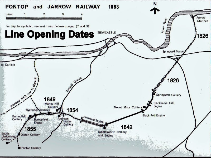
Continuing from my walk along the Tanfield Railway trackbed from the River Tyne. This route was another route built to connect collieries in the area to the River Tyne, though in this case at Jarrow to the east of Newcastle. It was built by the Grand Allies group of local colliery owners but much later than the Tanfield route from the 1820s onwards with later sections reaching Marley Hill and beyond by the 1850s. More information about the route can be found on the Wikipedia site.
Initial phases of the route were engineered by George Stephenson and the route used several incline sections, worked by gravity or by stationary engines. The last of these inclines remained in use until 1974, by which time the railway was operated by the National Coal Board.
Below - Map of the Bowes system from the Tanfield Railway Blogspot page.
Below - Map on the Suscram page giving more detail of the various inclines in operation.

Below - After crossing the road from the Tanfield Railway at Burdon Plain the trackbed is reached. In later years Blackburn Fell drift mine was accessed here and some sections of concrete road for loading coal in to lorries in the later years of this mine can be seen a little further along the trackbed.

Beyond this the route takes a dead straight course and climbs as it assends the Birkhead Incline to the site of Kibblesworth Colliery where an engine was situated. The site of this colliery is easily pinpointed as it is where the route curves to the left following the straight of the incline, the site has now become quite wooded.
The route crossed under that of the North Eastern Railway, now the East Coast Main Line. In more recent years this has become the site of Tyne Yard as part of the scheme to modernise the railways in the 1950s and 60s by concentrating freight workings on a series of large marshalling yards. In the picture below the route passes under the main line and the more modern concrete bridge that accessed the marshalling yard.

The line then passed under Lamesley Road and (Below) the A167. It can be seen that this bridge has been widened in later years, originally this would have been the route of the main A1 route to the north, this is now on a later 3 lane alignment to the east which we cross under in a concrete tunnel.

Beyond the A1 we reach the foot of the Black Fell Incline. Though Google Maps suggests taking another footpath it is possible to follow the railway route up the incline. Remnants of the railway can be seen including several sleepers.

Below - The inclined railway crosses a bridge, with rails in place.

Below - Towards the top of the incline the tracks are still in situ. The Black Fell Engine House can be seen at the top of the incline.


Below - What looks like it might have been a stone sleeper from an early waggonway.

Below - Fairly overgrown track around the Black Fell Engine House.

Below - An old Lancashire boiler at the side of the Black Fell Engine House.

Below - Restored winding wheel at the Black Fell Engine House.

Below - The Black Fell Engine House.

Below - Adjacent to the Black Fell Engine House is the remains of the sidings at the curve of the line next to Mount Moor Colliery (shown as Vale Pit in later maps) in the above map. As well as wagons from Mount Moor having joined the line behind me and to the right, this was the point at which cables were attached and dettached from the Black Fell Incline and the next incline, the Blakhams Hill West Incline to the sumit of the route at Blackhams Hill Engine.

1946 Map (the Bowes Route is the one on the right)
Below - The incline crosses a largely intact level crossing.


Below - Another level crossing on the Blackhams Hill West incline looking up towards the Engine House.

Below - Overgrown tracks near Blackhams Hill Engine House.

Below - The Blackhams Hill Engine House site is fenced off, it is part of the heritage railway in operatation on this part of the system, though it is some time since trains have reached here and the site has been prone to vandalism. The path takes a detour around the west side of the engine house and the operational section of Bowes Railway. A later chord on the Bowes line takes the line on to the former Ouston & Pelaw Waggonway and a run round loop at the site of a former quarry siding at Wrekenton.

Below - Adjacent to the Bowes Railway's base is a level crossing on Springwell Road, looking south west from the level crossing the track and rollers of the Blackhams Hill East Incline up to Blackhams Hill Engine Engine can be seen

Below - Blue plaque at the site of Springwell Colliery, now the base of the Bowes Railway which includes many of the workshop buildings.

The northern edge of the Bowes Railway's site is the top of the Springwell Incline, a self acting incline i.e. the weight of loaded wagons descending the incline by gravity hauled empty wagons back up the incline. This is the location where the ropes were attachd and detached at the summit.

Below - Looking down the Springwell incline and sadly we have now lost the rails.

Below - Having descended the Springwell Incline the remaining section of the route to Jarrow was locomotive worked. An engine shed housed locomotives for this level section at Wardley. This still survives, on the above map it is surrounded by fields but is now in the middle of a modern housing estate. This section of the route survived beyond the closure of the previous sections and their associated inclines in 1974, continuing in use primarily to serve Monckton Coke Works until 1986.

Below - Near Wardley Park the Bowes route passes over the disused Leamside line between Newcastle and Washington. Looking from the bridge to the trackbed below, the track of the Leamside line can still be seen. In recent years there have been proposals to reopen this as a local rail route which would free up capacity on the East Coast Main Line. Due to track thefts sections of the route were lifted and this now seems less likely. At the time of writing there are proposals to reopen this route as an extension to the Tyne and Wear Metro, linking in to their existing network at Pelaw and South Hylton.

1897 Map (top left corner of map)
The railway crosses over the Newcastle and Sunderland Railway which is still in use with Tyne & Wear Metro trains and local Northern Rail services. As we get towards Jarrow the area has been largely redeveloped with modern housing and though the railway route survives as a path, there is little to show that this was once a railway connecting local industry.
After passing Beech Street in Jarrow a chord linked to the Newcastle and South Shields railway (now part of the Tyne and Wear Metro system) in the Newcastle direction. The line passed under that route and on to coal staithes on the Tyne and steel works. A Modern industial estate now occupy the site of these.
Below - A Metro service on the South Shields line passes over the former rail route to the Tyneside staiths and steel works.

From here it is a short walk to Jarrow station and a Metro train back to Newcastle.
No comments:
Post a Comment