BROWSE JOURNEYS BY MAP VIEW

Saturday, 28 August 2021

Tanfield Railway

Starting Point - River Tyne side path, beneath Redheugh Bridge, Gateshead. Finish Point - Tanfield Railway, Marley Hill. Distance 5.1 Miles.

South of Newcastle the Tanfield Railway is the oldest railway still in operation. Now a heritage railway, the line operates on a section of waggonway built to move coal from mines in the area to the River Tyne that dates back to the 1720s. The abandoned section between the Tyne and the heritage railway is now a foot and cycle path.

Google Map

It might have been logical to start where the mines were and finish at the river where the coal finished its railway journey as it was loaded in to boats for onward travel, though it is far easier to get to Gateshead by public transport where it's a short walk to the path along the riverside. Now a popular footpath and cycle path along the river it is not apparent that this was once a rail route primarily to bring coal to the river.

1919 Map

Just west of the modern Redheugh Bridge (the abbutment of the original bridge can be seen) the Tanfield Route branched off from the later routes running along the Tyne that also ended up becoming part of the North Eastern Railway.

The route from the mines around Tanfield was built by the "Grand Allies" a group of coal owning families who teamed up to establish a route in order to overcome difficulties transporting coal across land owned by rivals. (A similar problem in Middleton, Leeds was overcome by legally establishing a route with the first act of parliament for a railway in 1758 resulting in the heritage railways at Tanfield and Middleton having similar sounding "world's oldest" claims.) Originally operated using horses, with the addition of gravity inclines and stationary steam engines, it eventually became part of the North Eastern Railway who converted the route for steam locomotive operation in 1881. The line remained in use until 1964 when the last colliery it served at East Tanfield closed.

More about the history of the route can be read on the Wikipedia article 

1898 Map

In the built up and still quite industrial area south of the Tyne, though the course of the railway is largely intact there is little to connect it to the past. In a couple of places there are slight detours off the course of the railway where the land is privatelly occupied. The first of these detours is at Ropery Road, which as the name suggests was the site of a rope works seen on the above map.

We pass under the railway bridge that once carried the line to the Dunston Staith (this will be a future walk), shortly followed by a bridge carrying the surviving line from Newcastle to Carlisle. Though these bridges cross Forge Road today (named after the nearby Dunston Forge) they originally carried their respective railway lines over the railway route to Tanfield here. Another detour is neccessary where the A1 and modern housing have obliterated the former trackbed, picking the trackbed up again on the corner of West Way. The tree lined path of the former railway route takes us through an area since redeveloped with modern housing until we reach Watergate Forest Park.

1947 Map

Watergate Forest Park was previously the site of Watergate Colliery. In the photograph below the path along the railway route passes the site of the pit head and its sidings.

1945 Map

Below - Approaching Street Gate a surviving bridge carries a farm track over the former rail route.


Below - As the route crosses Pennyfine Road remnants of coal staiths can be seen


Once we cross the A6076 we reach Sunniside, the southern terminus of the heritage railway. Though the trackbed is now still occupied by track, the footpath runs alongside the railway to Marley Hill. 
Below - Sunniside station, terminus of the preserved section of Tanfield Railway.


Below - The footpath crosses over the heritage line.


In the above map Bowes Bridge junction and an engine bridge can be seen. The footpath along the railway skirts the line to the east of these and the pit of the turntable shown on the map can be seen.


The Tanfield route crossed the Pontop and Jarrow (or Bowes) route almost at 90 degrees on a flat crossing with a signal box on the corner which can still be seen today.


To the left on the above photo is the Tanfield Railway's Marley Hill sheds. The complex incorporates the original two road stone shed that served the local collieries and was built some time before 1854 making it now the oldest engine shed still in use. Although the shed is on the former Bowes route a chord has been built to connect it to the Tanfield route.
The Tanfield Railway's main site is around Andrew's House station. There wasn't originally a station here, the name was derived from the nearby Andrew's House Colliery. The railway's car park occupies the site of the Gibraltar pit village. In the photo below the locomotive stops near the water tower, this has been constructed using two former colliery boilers to hold the water, a practice commonly seen at colliery locomotive servicing facilities. Old boilers were often either reused as water tanks or compressed air receivers.


From here it is possible to continue to East Tanfield by train. More details are at the Tanfield Railway website. At Causey Arch a branch went off to Dawson's Drift, this crossed over the Causey Arch bridge which was built between 1725 and 1726 and is the oldest surviving single arch railway bridge in the world and at the time was the longest single span bridge in the country. More about the bridge can be found on the Wikipedia article. Though a fire at the colliery it served in 1739 has seen this route long abandoned as a rail route there is still a footpath across the bridge.
Having quite an epic railway route walking day I didn't continue to East Tanfield (though have visited the heritage railway on a number of occasions) but instead continued my walk on the Bowes route all the way to Jarrow.

Saturday, 21 August 2021

New Lanark

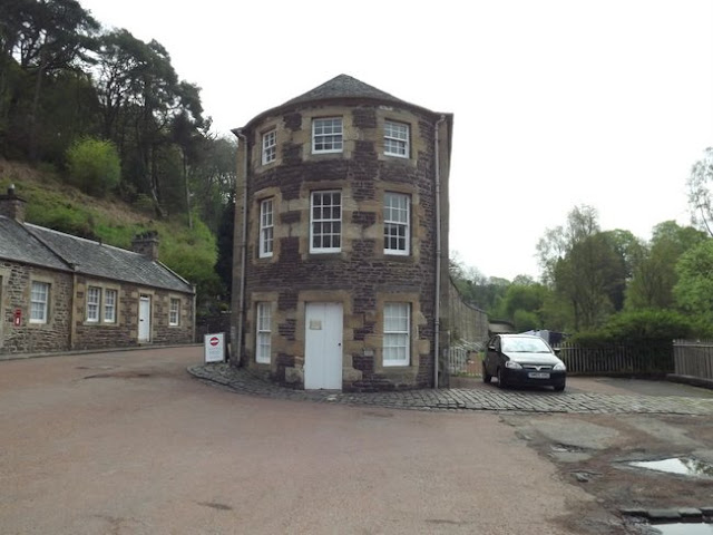
New Lanark was founded in 1786 as a model mill village by David Dale, initially in partnership with Richard Arkwright and later sold to Dale's son in law Robert Owen. Built to take advantage of water power from the only waterfalls on the River Clyde, the site included the cotton mills as well as housing for the mill workers and all the amenities required for the mill community. The mills operated until 1968 and after closure were saved for preservation. An important example of urban planning of the time, the site is now a UNESCO world heritage site.
Robert Owen improved on social reforms begun under David Dale, these included the first infant school in Britain in 1817. He bought out his partners who were pushing to cut back on such provisions for the workforce. The site showed that providing a decent standard of living for workers could result in a productive mill and the site received visitors from all over the world looking to spread such reforms.
Around 130 people live in the former mill workers houses. To maintain the character of the site phone lines and television are provided by underground cables and TV arials or satelite dishes are not permitted. As well as the residential use there is also a hotel and youth hostel on the site and several buildings that serve as museum buildings including Owen's house, a reconstructed shop and some of the mill buildings.
More about the site can be read on the Wikipedia article and the New Lanark website.
New Lanark is just south of Lanark and is a 1.7 mile walk from Lanark railway station.

Below are some of my photos taken on a look around the site.


Saturday, 14 August 2021

Hull and Withernsea Railway


Above - Old postcard of Withernsea station (Wikipedia)

Starting Point - Duesbery Street, Hull. Finish Point - Former Patrington Station. Distance 16.3 Miles


The line between Victoria Station, situated adjacent to Hull's Victoria Dock to the east of the city and the coastal town of Withernsea was opened in 1853. From 1864 trains from Withernsea continued in to Hull's main Paragon station via the Victoria Dock Branch and the station at Victoria Dock was closed to passengers, becoming Drypool Goods Station.
The line was closed as part of the Beeching cuts, closing to passengers in October 1964 and to freight in May 1965 apart from sections nearer Hull that clung on a little longer.
Much of the railway formation survives as far as Patrington, as a cycle route to Keyingham and continuing a bit further as a footpath to Ottringham (though the cycle route has gradually been extended eastwards so may continue further given time). Beyond Patrington the route has been ploughed in to adjoining fields aside from a short stretch through a park on the aproach to Withernsea. The former station site at Withernsea survived in to the early 2000s as part of Withernsea Market, however the market has been downsized and the station demolished with the site now occupied by the modern Withernsea police station. Excuse any puns but surely a criminal act of historic vandalism. Just a length of platform edge at the back of the car park survives of the station.
I covered the Victoria Branch as far as Wilmington on my ride of the Hornsea line which diverged at that point so for any that have read that account apologies for a bit of repetativeness as I go over that stretch again since I started this route at the same point, the Victoria Dock branch being a far better traffic free route across Hull than heading through the town and A63. Like my Hornsea journey I did this one out and back on my bike, though it could potentially be done as a walk by getting the bus back. 
The Victoria Branch joined the lines in to Hull Paragon at West Parade Juction, where a stub of the line survives to the Botanic Gardens depot in which Northern's trains for services centred on Hull are maintained. The first passenger station was provided at Botanic Gardens was on the north side of a level crossing on Spring Bank, now occupied by the Old Zoological pub. Just a section of retaining wall at the back of the Jet petrol station survives.

Below - Photo from Pinterest of a Withernsea train calling at Botanic Gardens.


Just beyond Botanic Gardens station site the railway trackbed can be joined at the end of Duesbery Road and soon brings us to the next station at Stepney where the line crossed the busy Beverley Road on another of its notorious level crossings.

Below - Stepney station with an installation of waiting passengers on the former Withernsea and Hornsea bound platform.


Not far from Stepney we reach Wilmington. The large goods shed that served the industrialised areas around the River Hull survives as a listed building but still in industrial use. The original Sculcoates station was situated at this point, though replaced in 1912 by Wilmington station closer to the junction on the other side of the river.


The swing bridge across the River Hull also carried a footpath and as a result was retained and manned for many years after the railway closed. The path has been moved from the side of the bridge on to the bridge deck that carried the railway lines. There is seldom any need to open the bridge to river traffic these days.


Below - The small station building of the later Wilmington station, behind the station can be seen the former entrance to the subway that gave access to a wooden island platform. The station site, and a lot of the surrounding area has been redeveloped for industrial use. As a result of this there is a bit of a detour at this point to pick up the railway trackbed at the back of Rosmead Playing Field where it passes under Southcoates Lane flyover alongside the surviving line in to Hull's docks. Unfortunately missing the site of Southcoates station, though nothing remains of this.


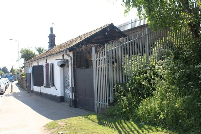
The former Marfleet station building survives in industrial use on the corner of Marfleet Avenue and Marfleet Lane, a tall metal fence now shield it from view from the railway trackbed. The platform edges can still be seen. The line survived a bit longer up to here for freight use until 1972 with several important industrial sites close by to the north of Hedon Road as a result of the nearby docklands. A couple of big names to have been based in the area included crane make Priestman and paint maker Humbrol. Now a vast site that we follow for a while on the right hand side is that of Willerby Caravans who make static caravans at the site.


The next station was Hedon Racecourse built to serve a nearby racecourse it was only used on race days and closed in 1909 when racing finished. The site was later used for speedway meetings resulting in it being briefly used again during 1948 under the Hedon Halt name. The platform edges can still be seen in the vegetation at the side of the track.
Hedon's main station survives largely intact as a private residence. Freight traffic also survived here a few years beyond the closure of the rest of the route, continuing 'til June 1968.

Below - Former Hedon station


The next stop was Rye Hill and Burstwick station, situated in a sparcely populated area between the two villages of its name, for a time it was just referred to as Rye Hill station. The station survives as a private residence.

Below - Former Rye Hill and Burstwick station


Next stop Keyingham also survives as a private home, and their is a slight detour around the station site at this point with the former trackbed now the driveway to the house.

Below - Former Keyingham station


The next stop at Ottringham was some way to the north of the village it served. This too survives as a home along with the platforms and goods shed.

Below - Former Ottringham station.


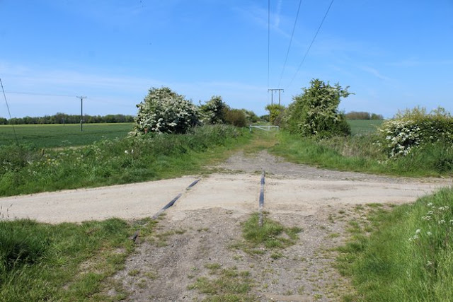
When the railway was removed most of the rails were left in situ at level crossings where they were set in to the road. Although most of the roads have been re-layed since, occasionally at a minor crossing such as a farm track rails can still be seen.

Below - Level crossing at Winestead Ings Lane between Ottringham and Winestead.


Beyond Keyingham the track was very much a footpath rather than a cycle path and though I continued on bike it was very much at a reduce speed as I contended with rabit holes and vegetation. The next station stop was Winestead which closed earlier than others on the line in 1904, though it remained open for freight until 1954 having a freight siding and a nearby brick works. The station building survived, probably for use as a house for the crossing keeper. It remains to this day as a private house. 
From here the trackbed has been taken over by the adjoining fields, though following Station Road it is not far to Patrington station. The station was situated some distance out of the village, being at the point the line curved north to reach Withernsea a station closer to the village would have seen the line going further out of its way. The station survives as an industrial site and the nearby Station Hotel survives.

Below - Former Patrington station and hotel


With the remainder of the route having been largely lost to time I didn't continue to Withernsea but instead cycled to Kilnsea from where I could walk along Spurn Head to look for remains of the Spurn Head Railway. An account of my visit to the Spurn Head Railway can be read here.

Below - A couple of photos of the former Withernsea station I took in the 1990s when the buildings were part of the market. Sadly they have now been demolished and just a small piece of the platform edge remains.


Saturday, 7 August 2021

Hull and Hornsea Railway

Starting Point - Duesbury Street, Hull. Finishing Point - Former Hornsea Station. Distance - 14.6 Miles


Opened in 1864 the route connected the coastal town of Hornsea to Hull's Victoria Dock Branch, the line saw just over a century of use before closing as part of the Beeching cuts of the 1960s. Today the line is part of the Trans Pennine Trail cycle route and some of the remnants of the railway survive remarkably well. I cycled out and back along the former route, though at 14.6 miles and with regular East Yorkshire buses back from Hornsea it would also work as a day's walk.
The Victoria Dock Branch connected to the lines in to Hull's main Paragon station at West Parade Junction and a stub of the line gives access to the Botanic Gardens depot where trains are maintained for Northern services centred on Hull. Growing up in Hull I can recall when Botanic Gardens was a much bigger depot and the lines continued up to Spring Bank and diesel units could be seen. The depot was downsized in the late 1980s though and the area to the south of Spring Bank is now the Jacksons Bakery.
North of the level crossing on Spring Bank was Botanic Gardens station. Previously named Cemetary Gates it was renamed, some say as elderley passengers never wanted to ask for a ticket to Cemetary Gates. The site of the station is now occupied by the Old Zoological pub. A bit of retaining wall can also be seen at the back of the Jet petrol station.

Below - Botanic Gardens station in 1967, closed to passengers at this time but still retained for Victoria Dock branch freight until the following year. (By Ben Brooksbank, CC BY-SA 2.0, https://commons.wikimedia.org/w/index.php?curid=10436210)


The cycle route can be picked up at the end of Duesbery Street and soon brings us to Hull's next surburban station on the Victoria Docks branch, Stepney. The main building and platforms of Stepney station are intact.


The Victoria Dock Branch was notorious for having several level crossings, including on the busy Spring Bank and Beverley Road here at Stepney. When the Hornsea and Withernsea routes were closed connections were made in the east of the city to the Hull and Barnsley Railway's line to Alexander and King George Docks, a high level route that crossed the city on embankments and bridges.
As the former Victoria Dock branch passes over the Beverley and Barmston Drain on a bridge the Hull and Barnsley Railway's line in to its Cannon Street station crossed over on a bridge to the west of the drain. The bridge was removed but the remains of the embankments can be seen and a footpath follows the former line.
After crossing the drain the former Sculcoates Goods Shed can be seen on the left. Also referred to as Stepney or Wilmington Goods Shed it was close to the River Hull and in quite an industrialised area so quite a large goods shed. It is a listed building and survives in industrial use.


The line crossed the river on a swing bridge, the bridge also had a footpath on one side of the bridge. The path resulted in the survival of the bridge and required that even after the railway closed the bridge had to be manned to open it for river traffic. During a refurbishment in the 80s or 90s the footpath was moved on to the main span of the bridge. Today there is little river traffic and it is probably a long time since the bridge has had to operate, though the cabin survives on the top of the bridge which is a listed structure.
Below - Wilmington Swing Bridge


On the left is the former British Extracting Co mill which had a connection to the former Hull and Barnsley Railway.


After crossing the river the next station was Wilmington, this served as a junction with the Withernsea line. It had a small station building on Foster St and a subway to access the wooden island platform. The station building survives as a cafe and the entrance to the subway can be seen at the back of it, though the station site has been redeveloped for industrial use.


Due to industrial redevelopment a detour is required to pick up the path at the end of Montrose street where the former Hull and Barnsley Railway route crossed over the Hornsea line and Foredyke Stream.
After Chamberlain Road a path curves off to the left at what was Stoneferry Junction, this was a short branch line to serve the Stoneferry Goods Shed and the riverside Premier Oil Extracting Mills and Earles Cement. 


As the former line passed under Church Street we reach the next station, Sutton. What would be a Hull suburban station if it were here today this was once more a village near Hull and when the line ran through the area the old maps show the line passing through little more than fields.

Below - Bridge at the site of Sutton station under restoration.


The next station was Swine, again a quite rural location it was situated where the line crossed Coniston Lane. The road would have been used to serve farms in the surrounding area and a coal depot was provided in the small goods yard so provisions could have been collected by cart as there was little development around the station itself.
Below - Former Swine Station


Below - Old coal drops at Swine station


Next stop is Skirlaugh station where the line crossed Oubrough lane, now the A165. Again there was little here but a small goods yard with coal drops were provided for the rural communities in the area. A car park for the Trans Pennine Trail is now provided at the former goods yard entrance for those wishing to drive here to explore part of the trail on foot or bike.
Below - Platform of former Skirlaugh Station


The first Ellerby station was another rural stop that only warrented a train on Tuesdays for market day. It closed in 1902 and the station building became known as Ellerby Gatehouse as it still housed the keeper for the crossing on Skirlaugh Road. On the north side of the road a single siding was provided, known as Ellerby siding when the station was closed. The station building survives though it has been extended in all directions, the extensions follow the character of the original building but this gives the impression that it was a much grander station.

Below - The original Ellerby station


Where the line crossed in a cutting under Lambwath Lane was the station of Burton Constable. A more substantial affair, this served the communities of Marton, Burton Constable and Ellerby when its own station closed. At various times the station carried the name of all three communities. The North Eastern Railway having other stations named Marton and Constable Burton it was felt these names would cause confusion. Today the path has been banked up to meet the road and the former station building survives as a private residence now screened from view from the former railway line by trees.


One of the best preserved stations on the route is Whitedale, another very rural stop with a simple goods yard and coal drops.
Below - Former Whitedale station


Below - Former coal drops at Whitedale


The next stop Sigglesthorne was between the villages of Little Hatfield and Great Hatfield after which it was named Hatfield until 1874 when it was renamed to avoid confusion with another Hatfield, a recurring theme on the route. Situated at the level crossing with Sigglesthorne Road, the platforms were staggered either side of the road and can still be seen, remarkably with the original wooden fences still largely intact.
Below - Former Sigglesthorne station.


The next stop was Wassand, previously Goxhill. Another rural stop that had a market days only service, this was closed to passengers in 1953 and goods in 1960 before the Beeching report saw the closure of the route itself.
Below - Former Wassand station


The next stop was Hornsea Bridge. Originally intended as the terminus of the line however it was decided to push on to the seafront despite the considerable increase in cost this entailed. Hornsea bridge had wooden platforms on an embankment where the railway crossed Rolston Road on a bridge. With the road subsequently widened, becoming the B1242, the bridge has been removed and the site of the station and goods yard redeveloped. Hornsea Bridge's goods yard served as the main goods facility for Hornsea itself.


A short walk from the sea front, Hornsea's main station was quite a grand building which survives to this day, though converted to houses. Though little changed on the frontage a couple of outbuidings were added on the former platform 3 side where there used to be a roof covering the platform and railway. Station Court was built on the site of platforms 1 and 2 that were effectively excursion platforms and lacked canopies or buildings but would generally only have seen use in the summer holidays. Adjoining the station the former station master's house survives and across the road the former Alexandra Hotel built to serve the station.
Below - Former Hornsea station


Below - Former station master's house at Hornsea.