Starting Point - Barnsley Main Colliery, Oaks Lane, Barnsley. Finishing Point - Fitzwilliam Station. Distance - 12 Miles
Below - Railway Clearing House map (from Wikipedia) showing the Barnsley Coal Railway in pink (for Great Central Railway who owned the line at the time) between Stairfoot and Nostell towards the left of the picture.
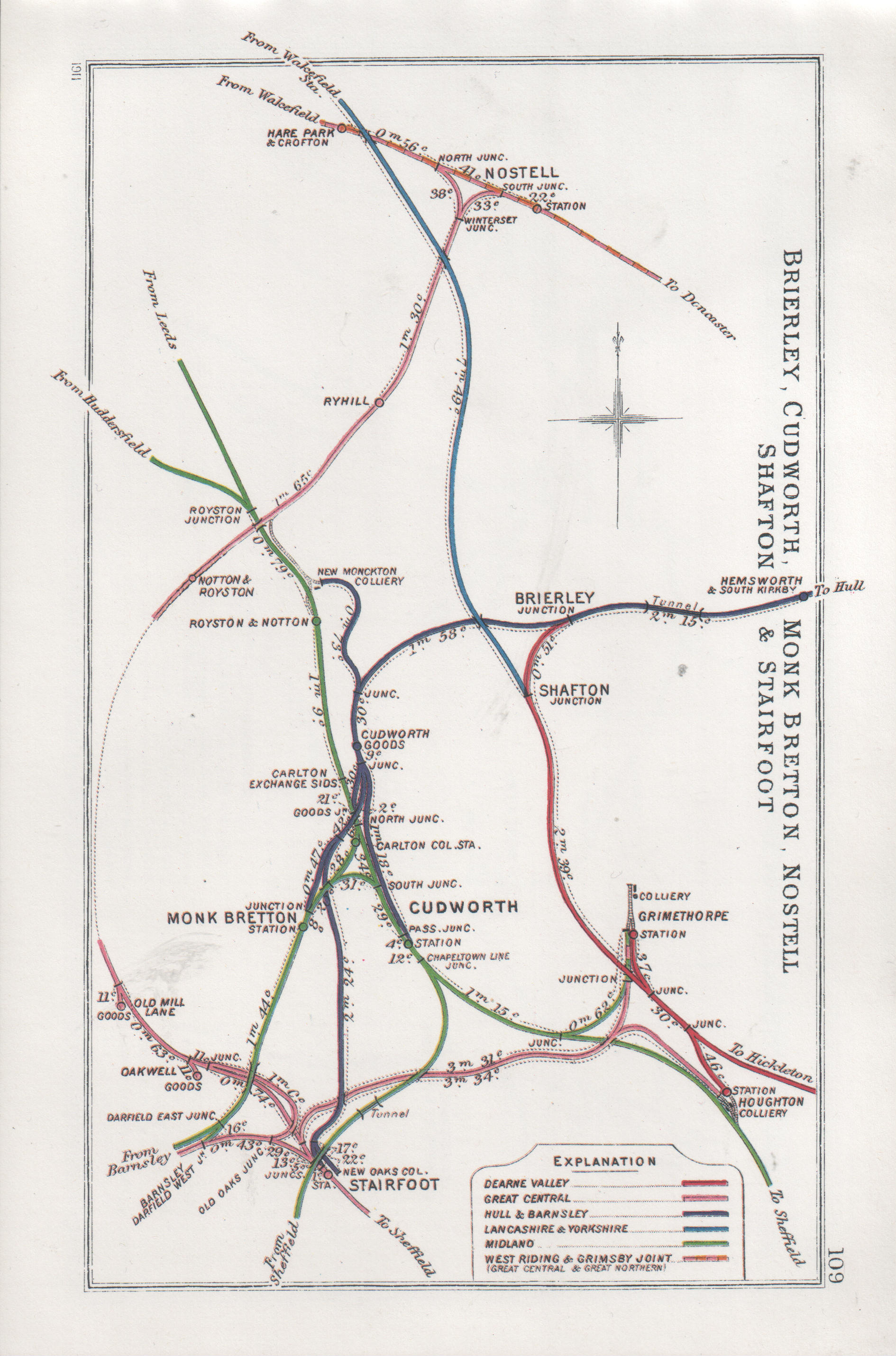
Primarily built to serve the local mining industry, the Barnsley Coal Railway connected Stairfoot Junction near Barnsley to Nostel on the West Riding and Grimsby Railway (now the section of the East Coast Main Line between Doncaster and Leeds). On completion the line became part of the South Yorkshire Railway which then became part of the Manchester, Sheffield and Lincolnshire Railway and later the Great Central Railway. A limited passenger service was operated from Leeds Central to Barnsley Court House but this finished as early as 1930, goods traffic carried on until 1961. More information about the history of the route can be found on the Wikipedia page. Today there are footpaths along much of the route.
Having travelled to Barnsley by train I walked to Barnsley Main Colliery on Oaks Lane, close to Stairfoot Junction where the route began. Here some of the pit head buildings have been preserved.

Below - Around Barnsley Main Colliery some of the narrow gauge internal railway system is in situ in the concrete roadways.

From here it was a short walk in to the Dearne Valley Country Park, through which the route now forms one of the paths through the park.
Below - Where the path crosses the River Dearne it does so on the site of southern most bridge of the two railway bridges that can be seen in the above map. The abutment of the northern most bridge can be seen.

Below - Remains of an aqueduct that carried the connection between the Aire and Calder Navigation and the Barnsley Canal


As the course of the railway leaves the country park as it passes under a modern bridge under Tannery Road the trackbed has been lost under a modern road junction. Continuing along Wakefield Road the former Old Mill Lane goods depot can be seen across the industrial site that now occupies the former trackbed.

The railway trackbed is rejoined just off Smithies Lane just before it crosses Smithies Lane on a surviving bridge. Looking down at the abutments (not very clear on the photo for the trees) it can be seen that there were two bridges spanning the road, the missing one on the left having served Wharncliffe Carlton Colliery. On the right was access to Primrose Main Colliery. Some retaining walls can be seen in the trees on the right with industrial units and a bus depot on the former pit site.

Beyond Primrose Colliery was East Gawber Hall Colliery, though the colliery has gone and the site landscaped over. As the former line skirts the modern housing of New Lodge there has been a lot of landscaping since the mines and railway were in existence. The old maps show the railway going from an embankment to a steep rock lined cutting which aren't evident today, though the route is still a path across the fields and popular with dog walkers from the areas of modern housing that have sprung up nearby. A former British Coal sign is a remarkable survivor though. At this point the former trackbed was later used as a road access to East Gawber Hall Colliery.

Below - Though partially infilled, the bridge carrying the A61 over the former railway is still in situ.

This was the site of Staincross Station, the former station master's house survives as a private residence.

Below - The site of Staincross station. The path on the right is the former passenger access from the road to the station.

Just beyond Staincross station the branch to Wharncliffe Woodmoor Colliery went off, this was through North Rounds Wood on the 1893 map but today the wood has gone and the course of the branch forms the northern edge of the modern housing of Athersley North.
Below - Former junction of the Wharncliffe Woodmoor Colliery branch.

The bridge across Lee Lane is gone and a section of embankment alongside Muscle Hill Farm levelled, though the path climbs to join the former trackebed behind the farm buildings. Where the line curves to the right a branch once went off straight ahead to serve a quarry, this must have been short lived as it was already dismantled on the 1893 map. Much of the branch has been ploughed into the adjoining fields but is still evident on satellite views.
A short stretch of the trackbed was quite badly flooded when I visited so I had to take a detour around it using a footpath that connected to Parkhead Close, another path off Applehaigh view returned to the railway and this was an old footpath that existed when the railway was built so the remains of a bridge could be seen.
Below - Looking back along the flooded trackbed when I picked up the route.

At Bleakley Lane another bridge has gone. To the east of the road was Notton for Royston station, the trackbed is regained by taking what was originally the access road for the goods yard up the embankment. The former station master's house survives as a private residence at road level on the North side of the station site.
Below - Bridge abutment on the west side of Bleakley Lane.

Below - Former goods yard access road on the left and a bit of brickwork, possibly from the platform, on the right.

Beyond Notton for Royston station the line passed over the Midland Railway route at Royston. A chord branched off to connect with the Midland line in the northbound direction, though this chord had been disconnected in the 1893 map and was removed on subsequent maps. It is therefore quite remarkable that the footpath bridge over this long closed line is still intact.

The viaduct that carried the line over the Midland route and the canal has gone and the embankments up to it levelled off at both sides. A little deviation is necessary here along Navvy Lane and Church Lane.
Below - Navvy Lane crosses the former Midland Railway line, once one of the main routes between Leeds and Sheffield only a section of the line from Wakefield to Monk Bretton survives as a single track freight line to supply sand to a glass works. This was the site of the Midland's Royston and Notton station.

Church Lane crosses a footpath along the former Ryhill Main Colliery Tramway, this runs west up to where it met the Midland Line and the canal. Heading east that path heads to the site of Ryhill Main Colliery and it is where that line passed under the Barnsley Coal Railway that we can access the former trackbed again. The route has been ploughed in to the fields between the Midland line and this point.
Below - Looking along the Ryhill Main Colliery Tramway, on the right is the footings of the abbutment for the bridge that carried the Barnsley Coal Railway. The path heads up the embankment to the trackbed.


Below - Old farm track bridge still in situ.

Approaching the site of Ryhill station, the Station Road bridge has been filled in but the path can be picked up on the north side of the road. The path was quite overgrown, remnants of Ryhill station's platform could be seen (below).

Below - Another missing bridge but with surviving abutments where the railway crossed Long Dam Lane.

Below - The next bridge taking Back Lane over the trackbed was still in situ.


Below - Towards the top of the above 1893 map earthworks for a level crossing can be seen, though it was not connected to the nearby roads so was presumably a farm crossing. The earthworks can still be seen though and the gate posts are still in place.

A little further north the later Dearn Valley Railway crossed over the Barnsley Coal Railway on a bridge. Both old lines are now footpaths at this point (and I hope to walk the Dearn Valley line at some point) though the bridge is gone and the paths cross on the level, those of the Dearn Valley sloping up to embankment height.
At Winterset Junction two sides of the triangular junction with the main line from Leeds to Doncaster diverged, a bridge that carried a farm track is still in situ at the site of the junction.

Within the former triangular junction was a coal terminal alongside the surviving main line. This was used in to the 1990s to move coal from opencast mines in the area and known as Winterset Coal Sidings. Though now disconnected, the sidings are still in place.


With this being the junction with the surviving main line that marks the end of the old railway walk, though there was still a bit of walk remaining to reach Fitzwilliam station for a train home. I found an underpass under the mainline at the site of Nostell South Junction flooded, I had hoped to look for remnants of the branch line in to Nostell Brick & Tile Works. Instead I had to carry on to Swine Lane.
Crossing over the mainline, nothing remains of Nostell station except for the Station Cottages. The brick and tile works is still in existence. After passing the brickworks I took Gamil Lane towards Fitzwilliam station.