BROWSE JOURNEYS BY MAP VIEW

Showing posts with label Roman. Show all posts

Friday, 12 December 2025

Roman Caerleon

A visit to the Roman sites of Caerleon by bus from Newport


On the outskirts of Newport in South Wales the village of Caerleon has several remains of the Roman Legionary fortress of Isca Augusta. This was one of only three permanent Legionary fortresses in the UK, the other two being at Chester and York. The name Caerleon means City of the Legions, though after the fall of the Roman Empire Caerleon did not go on to be a major city as Chester and York did and the Roman remains decayed over centuries rather than being built over.

Caerleon had a railway station but it closed and trains now pass the former station without stopping. It is possible to walk from Newport but a bit of a long way round due to crossing the river so I took a bus.

While the star attraction is the amphitheatre there is also the barracks, a bath house, a Roman garden and a museum to see in Caerleon.
Starting with the museum (on Museum Street), the National Roman Legion Museum is one of the National Museums of Wales and features displays about the site as well as finds from digs around the town. More information about the museum can be found on the Museum's website. The museum is situated close to what would have been the centre of the walled fortress complex.
Next to the museum is a reconstruction of a Roman garden featuring some of the herbs that would have been grown for medicinal purposes.
Just to the east of the museum off High Street is the Caerleon Roman Baths complex, this is managed by Cadw. The foundations of the baths complex are housed in a purpose built building. Displays are situated around the remains of the buildings and projections on to the remains explain how the bath complex worked (though this wasn't good for photography). More information can be found on Cadw's website.
The Amphitheatre is also managed by Cadw but is out in the open and is free to visit. There are little in the way of visitor facilities at the outdoor sites of the Amphitheatre or Barracks so it's good to use the facilities at the indoor sites of the museum or bath house. There is just a public toilet next to the Amphitheatre car park.
The Amphitheatre is situated on Broadway, once the main road into the fortress from the south west, it would have been located just outside the walls of the fortress next to the south west gate. More information can be found on Cadw's website.

Below - Some photos taken around the Amphitheatre.


Below - Photo on one of the information boards showing the excavation of the Amphitheatre after centuries of animals grazing on the largely buried ruins.


From the Amphitheatre a footpath leads to the Roman Barracks, also managed by Cadw. More information can be found on the Cadw website. The foundations of one of the barracks blocks survive and those of a couple more have been recreated to better demonstrate how the complex would have looked. The recreated parts are set higher than the original ruins to differentiate them.

Below - Remains of the original barracks block. Eight men would have shared a pair of rooms. The reconstructed outlines of further blocks are higher up on the right of the picture.


Below - The end of the block with the more extensive accommodation for the Centurion and his staff. The reconstructed parts can be seen on the left.


 Having visited the Roman sites around Caerleon I returned to Newport by bus.

Saturday, 13 September 2025

Roman Chichester

A visit to Roman remains at Chichester and Fishbourne

Noviomagus Reginorum / Chichester

Prior to the Roman invasion of Britain in 43AD there was no significant settlement at the site currently occupied by Chichester. It soon became a significant staging post of the invasion and and important Roman city. Many remnants of Roman times remain in and around Chichester.

Below - Map of medieval Chichester showing the walls whose origins date to the establishment of a city here under the Roman occupation. The common Roman feature of North / South and East / West roads crossing at the heart of the city can be seen.


Below - One of the most significant pieces of Roman infrastructure are the walls around Chichester that mostly survive to this day, though they have been altered several times over the centuries. This is the wall at the South Gate Car Park which being the closest piece of wall to the railway station is where I began a clockwise walk around the walls. The south gate would have been on South Street to the right of the shot.

Below - A well preserved stretch of wall on the south side of the city.


Below - Information board next to the wall where it meets the A286.


A bit of wall is missing along the A286 and the wall is picked up again at North Walls just off the Westgate Roundabout. West Gate itself would have been across West Street and does not survive.

Below - At North Walls a stretch of wall can be walked along the top of the wall.


Below - The walls crossing Chapel Street, one of only a couple of gates in the wall but would have been added much later.


Below - Another information board (click to enlarge).


Below - Looking across Jubilee Gardens, sight of a medieval castle, the mound of the motte of the motte and bailey castle can be seen.


Below - Information board at the above point.


Below - Site of a gate at Priory Road, the steps up the surviving wall can be seen.


Below - Top of the wall at East Walls.


Below - The site of East Gate over East Street.


A bit of wall is missing around the south east corner, the wall is picked up again at the Market Avenue car park.

Below - The walls at the back of the Market Avenue car park with the other surviving gate cutting through to Cawley Priory car park.


Below - The wall seen from the inside at the Cawley Priory car park.


This section of wall ends at Theatre Lane which brings me back to where I started at the site of the South Gate.

Another significant Roman remnant is the former bath house that is preserved in the Novium Museum built over it.

Below - Remains of the bath house in the floor of the Novium Museum.


Also to the east of the former walls the park at the Litten occupies the site of an amphitheatre. A mosaic survives in Chichester Cathedral, however there was an event on at the Cathedral at the time of my visit.

Just a couple of miles west of Chichester's former South Gate is the Fishbourne Roman Palace. It was known that there were Roman remains were situated here following housing development in the area around 1805. Remains of the grand palace, particularly it's fine collection of mosaics, were uncovered in 1960 when a new water main was being installed in the area. The villa dates back to 75AD and was thought to have been the residence of a pro-Roman local chieftain who aided the Roman conquest of Britain. The site was key to the Roman invasion of Britain with goods landed in a harbour nearby and granaries built in the area around the time of the 43AD invasion. I got the train from Chichester to Fishbourne and it is a short walk from Fishbourne station to the museum.

More information about the museum established at the site can be found on the Sussex Archaeological Society website.

Below - A model of the palace at the entrance to the museum. The remnants on display are mostly from the north wing of the building to the left.

Below - A piece of hypocaust.


Below - The mosaics uncovered in the excavation of the site.


Below - When some of the murals were lifted for refurbishment they revealed earlier mosaics underneath. These have been installed in rooms where mosaics haven't been found.


Below - Remains of a bath.


Below - Site of the main entrance to the complex.


Below - Modern colonnade of the museum building alongside the original colonnade of the north wing of the villa.


Saturday, 24 September 2022

Chester's Walls

A circular walk of Chester's city walls. Distance 2.5 Miles.

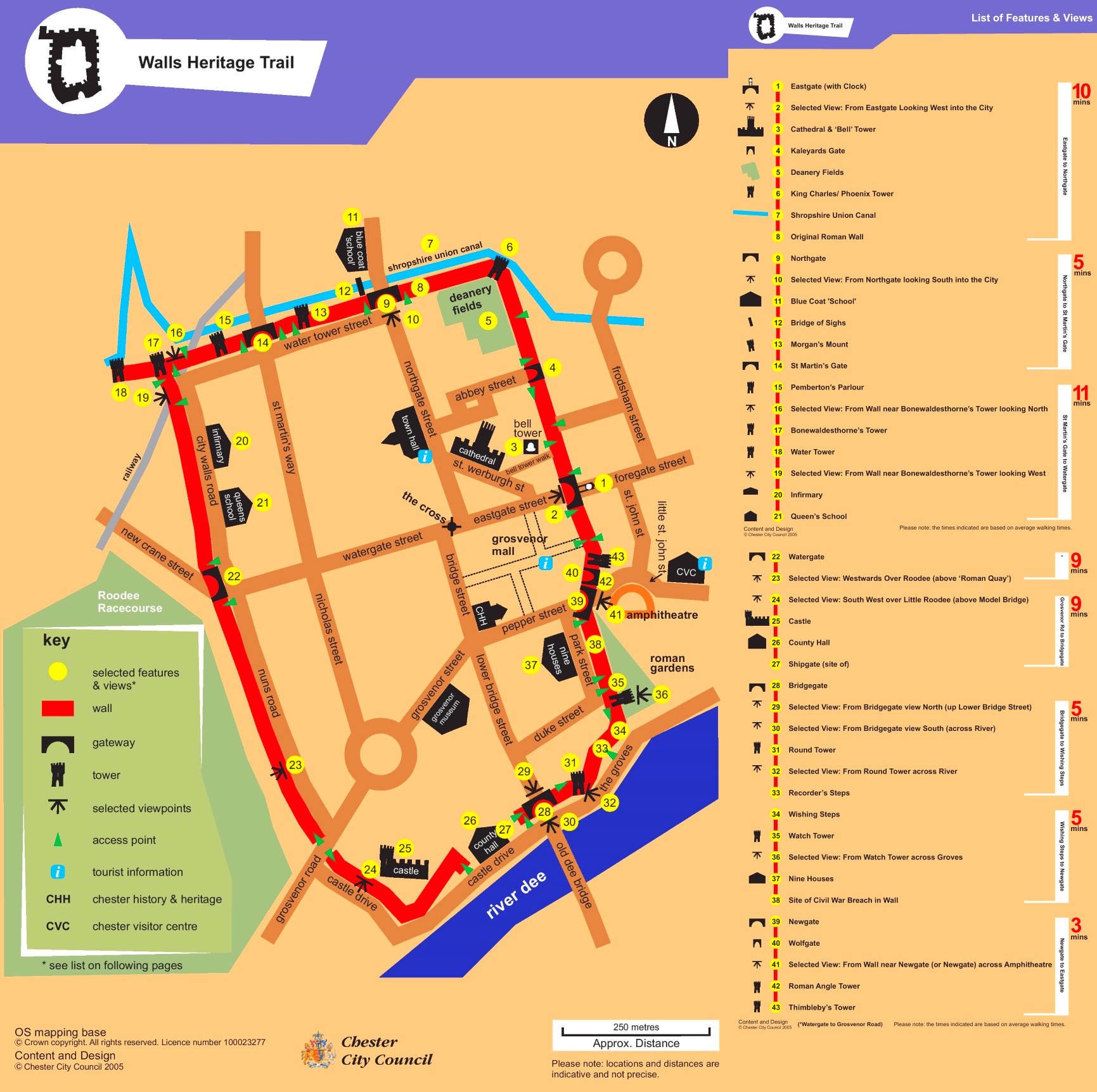
More information about Chester's city walls can be found on the Chesterwiki site with much more detail of all the sights and links to several walking tours described at various time in history. With several other sites providing thorough historic detail of the walls my own account will just serve as a brief pictorial account of a walk around the walls.
The walls have had a few phases in their history. Much of the North and East sides date back to the Roman fort. The walls were rebuilt and extended in medieval times as the city expanded to the south and west. From the late 18th Century as the walls no longer had a defensive function and the roadways needed widening the gateways were rebuilt and the walls became a picturesque walkway around the city.

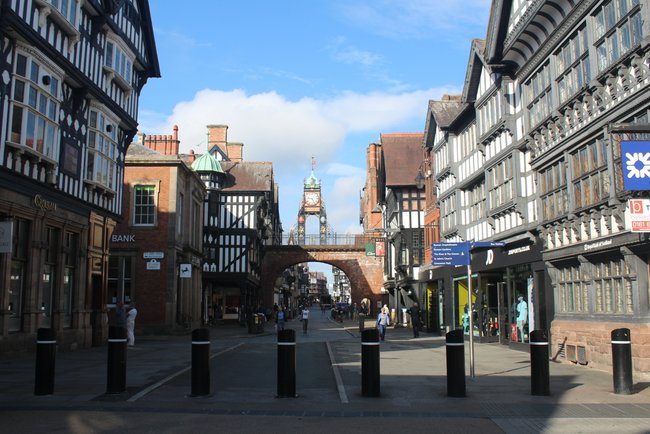
Below - I started at East Gate, effectively the 'main entrance' to the city as it faces the road from London, or in my case the railway station.


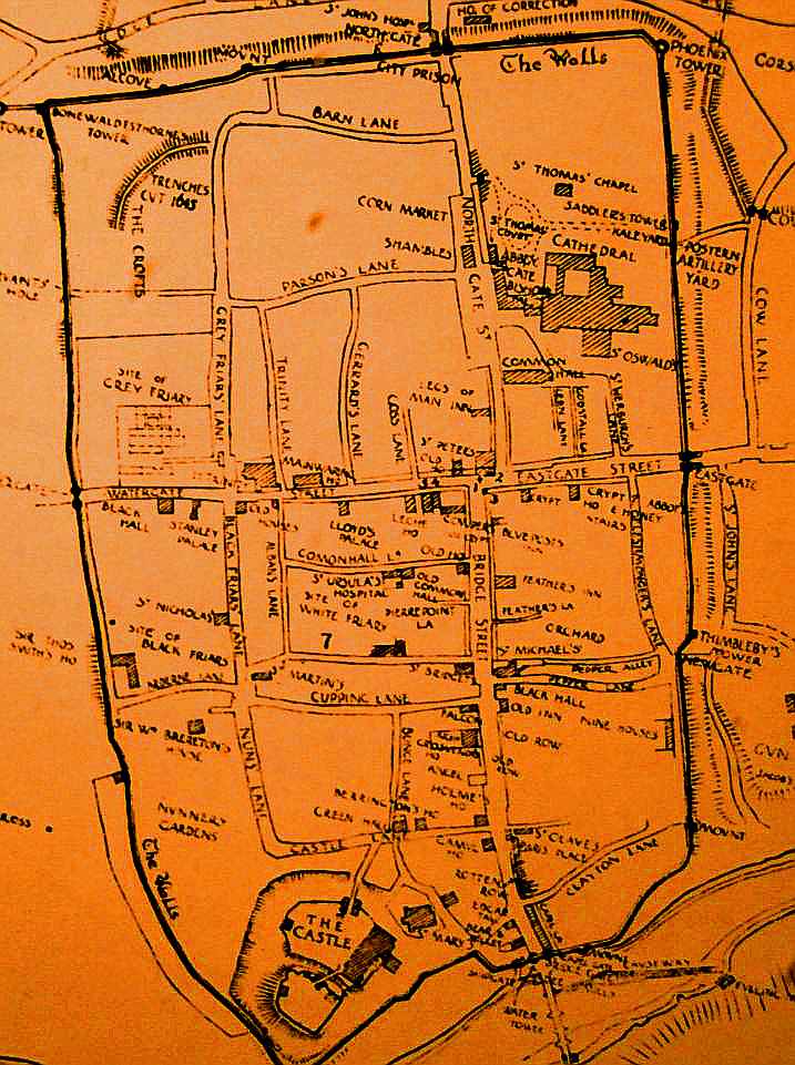
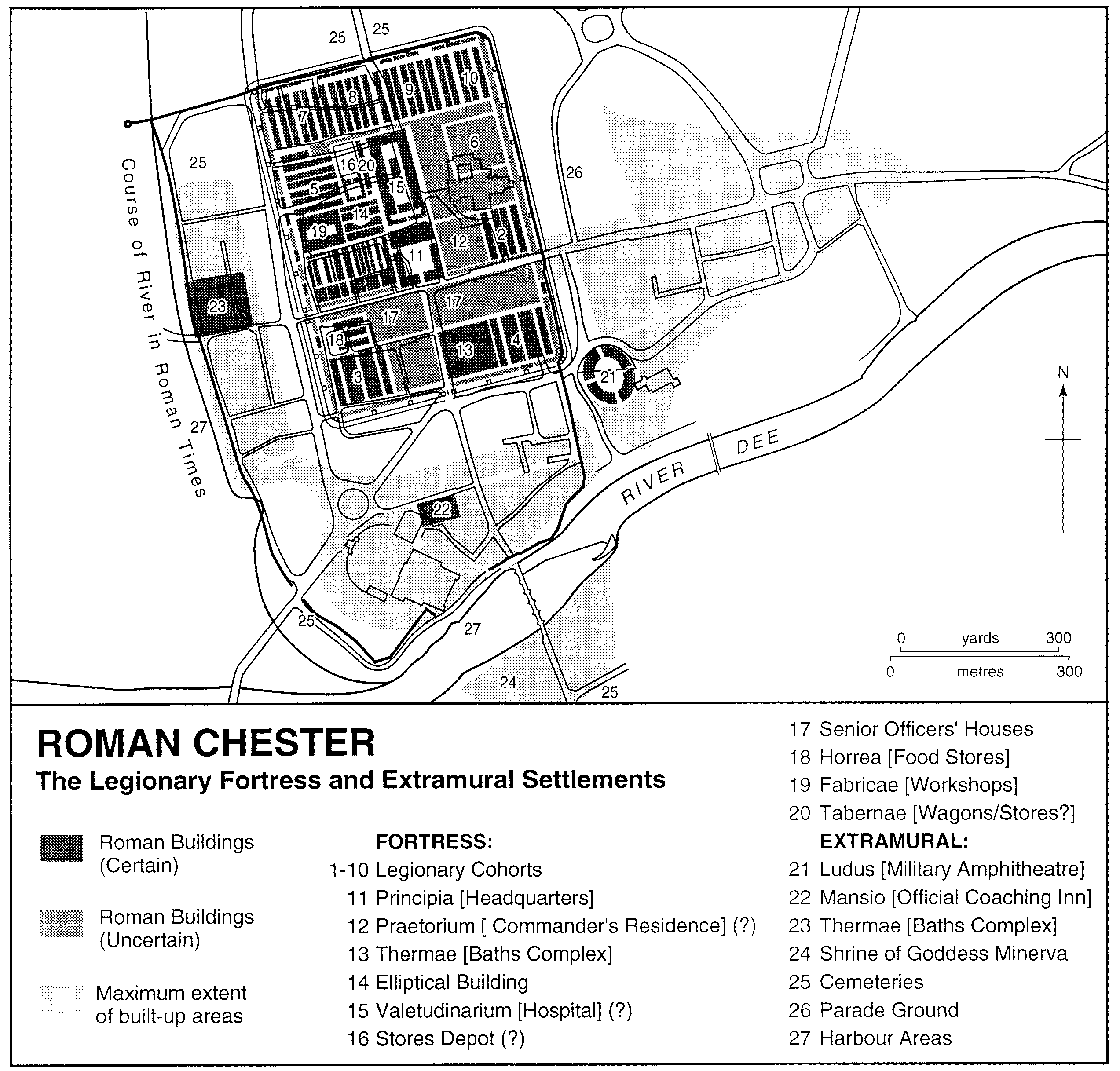
Generally at this point I'd post links to Victorian maps or something but in this instance I've added the best map of each era I could find.

Below - Roman Chester map from British History Online, this is of course a modern map. It also shows how half the walls of the Roman Fort were incorporated into the walls of the expanded medieval city.


Below - Medieval Chester, map from the  Chesterwiki site 


Below - The modern city walls walkway.


Below - Heading south from East Gate I reach Wolf Gate (the small arch on the right). In 1938 it was replaced with New Gate on the left, the newest gate on the city walls.


Close to Newgate the foundation of a Roman corner tower can be seen, the south wall of the Roman fort which headed east from here was removed and beyond this point the walls were of medieval origin.

Below - Foundations of the Roman corner tower with the Wolf Gate seen in the background.


Also outside the city walls near New Gate are the remains of the Roman Amphitheatre and alongside a stretch of the medieval wall are the Roman Gardens in which various pieces of Roman stonework found around the city have been displayed.


Below - From the Roman Gardens the site of a repaired breach in the walls from the Civil War.


Below - Some of the Roman artifacts on display in the Roman Gardens.


Below - Section of a Roman bathhouse reconstructed in the Roman Gardens.


At the South of the city a Roman Bridge crossed the River Dee, the river is still crossed by a bridge at this point. As with the other former gatehouses in the city walls this has been replaced with a wider archway when the walls ceased to have a military function.

Below - The Bridge Gate


Below - The Old Dee Bridge.


The Roman gate for people approaching from the south would have been some way to the north of this later gate on the lost southern wall of the Roman fort. It would have been close to where White Friars meets Bridge Street.

Below - Site of the south gate in the fort walls today.


Chester Castle is situated within the medieval walls in the south west corner.The castle is managed by English Heritage and is open to the public.

Below - Chester Castle. 


Below - The Water Gate. Where the Racecourse now stands was once the harbour until the River Dee was diverted around the Racecourse.


Again the equivilent gate in the lost Roman west wall can be found a couple of blocks in from the surviving gate. The Roman wall would have stood to the east of St Martin's Way.

Below - Site of the Roman west gate which led out towards the harbour.


Below - The railway cuts through the north west corner of the city walls. Though the bridge below looks like a regular footbridge it is in fact carrying the walkway along the walls over the railway.


Below - The Water Tower at the north west corner of the walls.


Below - Information board on the Water Tower.


Below - The section of wall and tower that protected the harbour from the north.


Below - The wall walkway crossing the railway again.


Below - Pemberton's Parlour.


Below - Information board on Pemberton's Parlour.


Below - Where St Martin's Way passes under the walkway along the city wall was the site of the North West corner of the Roman walls. This has been marked by a plaque and marked out in the paving.


Below - Morgan's Mount, a former watch tower close to what was previously the north west corner of the Roman walls.


Below - Information board on Morgan's Mount. An old painting made at the site serves as an interesting then and now comparison. 


Below - at the foot of Morgan's Mount is a sculpture of a broken Civil War cannon.


Below - North Gate.


Below - On the inside of the walls is evidence of a bricked up archway just west of North Gate.


Below - The Shropshire Union Canal seen from Northgate Street with the walls on the right.


Below - The King Charles or Phoenix Tower at what was the north east corner in the walls since Roman times.


Below - Close to the King Charles / Phoenix Tower the Roman and Medieval phases of the wall can be seen.


Below - The walls passing the Cathedral.


Below - The Cathedral seen from the cloisters.


After passing the Cathedral I arrive back at Eastgate having completed my circuit of the city walls

Whilst in Chester I also visited the Deva Roman Discovery Centre close to the site of the Bridge Gate in the lost south wall of the Roman fort. This houses displays about the Roman fort and examples of the complex layers of archaeology beneath the city.