The East Lancashire Railway is known for the heritage railway that operates between Heywood, Bury and Rawtenstall. This was just a part of a network of lines in the area, the line to Rawtenstall being a stub of the Baccup branch that diverged from the mainline between Bury and Accrington just north of Ramsbottom. Whilst passing on ELR trains a couple of viaducts of the route towards Accrington can be seen alongside and much of the former route (except for part of the route which is now the Haslingden Bypass) is now footpath. I started at Accrington and walked to Ramsbottom.
ACCRINGTON
Accrington station was once a triangular junction with platforms on the north and east sides. The west side had goods lines only and access to the goods yards. Now only the north side of the triangle remains with the two platforms serving trains between Preston, Burnley, Colne and Leeds, the rest of the station site is now a Tesco superstore. Though part of the station remains in use the station is included on the Disused Stations website for the Bury line platforms which no longer survive.
Below - On the west side of the triangular junction, the former "Accrington and Blackburn Junction," the Hyndburn Greenway runs alongside the live railway where there had previously been four or more tracks and sidings. The Hyndburn Greenway runs towards Church and Oswaldthwistle station to the west and the former Baxenden station on the former line to Ramsbottom to the the south.

Below - On the corner of Scaitcliffe Street and Ormerod Street is the former Globe Works. The railway crossed overhead where I'm standing here.

Below - The Hyndburn Greenway passes the metal columns of the former viaduct across the reservoir.


Below - Footpath bridge over the former railway.

Below - Retaining wall at the back of where a signal box once stood, shown as SB on the old map.

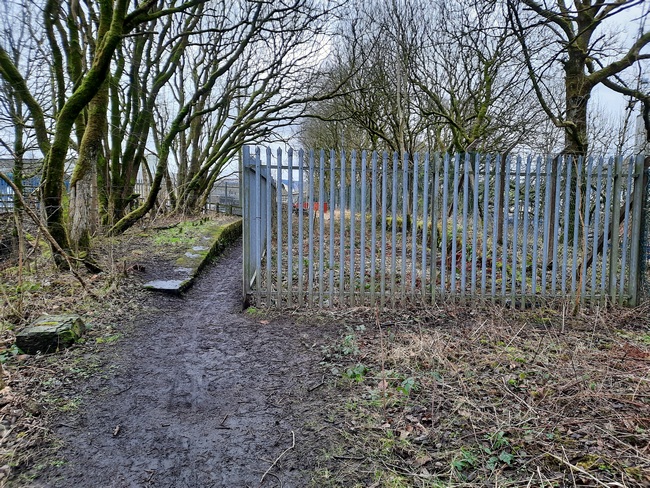
Gateposts from a footpath crossing next to the signal box.

Below - Retaining wall where the railway ran closest to Woodnook Water.

Below - The former Alliance Mill.

1930 Map (bottom left of map)
Below - The former Victoria Mill.

Below - Victoria Mill and the bridge over the railway.

Below - Concrete hut at the side of the trackbed.

Below - What looks to have been a lamp bracket at the side of the track.

Below - The former trackbed running alongside the reservoir

BAXENDEN
The old map shows the Paragon Chemical Works on the south side of the station, there is still a chemical works here today shown as the Baxenden Chemicals. On the north side of the station site the goods yard and a former cotton mill site are now occupied by the Hollands Pies factory. At the station site itself both platforms survive with a fence between the two platforms dividing the site. At this point the footpath turns off the former railway trackbed and emerges on to Blackburn Road. With the Haslingden Bypass using the former railway route for a stretch there is a bit of a detour on nearby roads.
Below - The platforms of the former Baxenden station.


Below - Culvert under the station site.

Below - The former goods shed, now part of the Hollands Pies factory site.

Below - The former road access to the goods yard.

From Blackburn Road I turned right on to Rising Bridge Road which crosses over the former railway before running along side it on the south side. It can be seen that the cutting has been filled since the railway closed.
Below - Rising Bridge Road bridge over the former railway, now filled to the same level as the road.

From Rising Bridge Road, Hud Hey Road crosses over the bypass where it follows the former course of the railway, though it does so on a modern concrete bridge. Just south of here a footpath runs along the east side of the bypass, accessible off Carr Hall Street.
Below - The former Britannia Mill. To the right of the picture the footpath passes through the former goods yard site

Below - The former Britannia Mill and Victoria Mill looking across the site of the goods yard. The bypass runs along the site of the running lines.

HASLINGDEN
Below - The former Haslingden station site. South of the station was a tunnel which was removed when the course was widened for the bypass.

Below - The end of Station Road, the access to the goods yard would have been through the fence on the left.

Commerce Street crosses the bypass where it used to cross the railway but again doing so on a modern concrete bridge. There's a bit more detour on roads to the west side of the former railway as the bypass occupies the route.
Below - The bypass leaves the course of the railway as St Crispin Way runs alongside the former trackbed. Just south of where they diverge is this bridge that took the railway over the access to Flash Mills. There is no path on the embankment at this point.

The bridge over Grane Road has been removed, south of Grane Road the trackbed can be accessed again from a footpath off the access road to Swinnel Brook Park.
Below - The former Holme Spring Mill seen from the former railway.

Below - The bridge over Ogden Brook has been removed and the path descends from embankment to ground level to cross the steam on a footbridge which seems to be built on abutments of the former railway bridge.

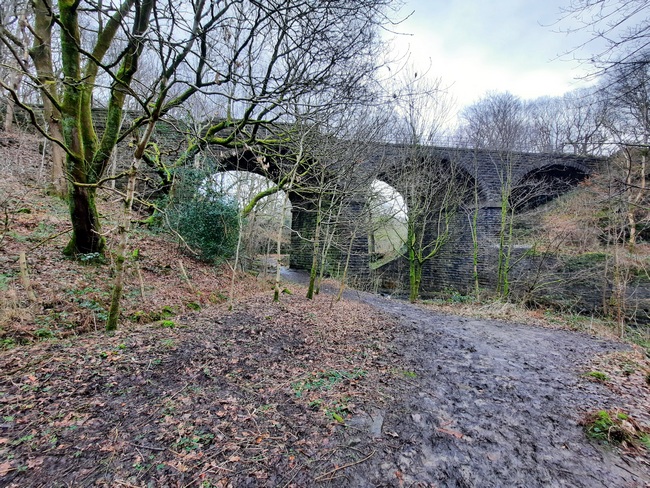
Below - Helmshore Viaduct.

Below - The former Higher Mill survives as a textile museum (see their website). Unfortunately it wasn't open on the day I visited otherwise it would have been worth a stop off on the trip.


Below - The road from Helmshore Cottages to the mill passing under the viaduct.


HELMSHORE
The footpath leaves the railway route again before the site of Helmshore station, emerging on to Ogden Drive which leads on to Station Road. The station site and that of the goods yard and nearby Albion Mill have been built on with houses.
Below - Looking west from Helmshore Road this is the site of the station.

Below - Looking east from Helmshore Road, it looks like a signal box and it is where the signal box stood but that was a brick and wood structure and this is a modern building. Note the gate post and the lamp bracket. The former station master's house survives opposite.

Below - Off Holme Vale (Snig Hole) the footpath to New Barn (now the name of a residential street rather than an actual barn) still crosses the former railway on the original bridge. The bridge to the west of it survives but seems to be isolated within private land.


Returning to Snig Hole a footpath to Irwell Vale Road follows the north bank of the River Ogden and passes beneath the viaduct over the river, the trackbed itself not being accessible at this point.
Below - The viaduct over the River Ogden.

From Bowker Street and Milne Street the footpath back towards Snig Hole gives access to a footpath on the railway trackbed south of here.
Below - Lumb Viaduct over the River Irwell.


Below - A concrete lineside hut.


Below - Lumb Viaduct from the footpath to Irwell Vale. This is where the preserved railway runs alongside. The ELR has a station here which was not originally a passenger station but the site of sidings to serve local mills.

Below - Another viaduct over the River Irwell, Alderbottom Viaduct, this time with metal spans. As can be seen on the map it is alongside the Baccup Branch which is now part of the heritage line to Rawtenstall.

Below - Looking south towards the junction of the two lines at Stubbins.

Below - The end of the line for the footpath as it emerges on to Strongstry Road with the bridge over the road fenced off.

Below - The bridge over Strongstry Road.

I had to follow the roads in to Ramsbottom as from the nearby junction the trackbed is in use with the heritage railway.
Below - Stubbins Vale Road passes through the Stubbins Vale Mill site.

STUBBINS
The Accrington line passed to the west of Stubbins station which just had platforms on the Baccup branch before joining it just south of the station. Though the Baccup branch is now run by the heritage line as far as Rawtenstall the station hasn't been restored. The platforms can be seen from passing trains. This means Stubbins was not a stop on the route I've been covering but as I passed the former station it would be daft not to take a look at the site.
Below - The subway under the north ends of the platforms. Where the subway is open in the foreground the two tracks of the Accrington line crossed.

Below - The steps up to the northbound platform seen through a wire fence with the fence around the subway entrance seen on the abandoned platform at the top.

Below - The steps to the southbound platform seen through a wire fence. The fence along the platform can be seen at the top.

Below - Glazed tiles in the subway.

Below - The entrance to the subway at the north end of Stubbins station. Some landscaping seems to have been done here with the land levelled off up to the railway.

The main station building stood on the other side of the bridge taking Bolton Road North under the railway but has since been demolished, a small car park occupies the station entrance site. What looks like it may have been the station master's house stands nearby.
RAMSBOTTOM
Ramsbottom station was almost entirely demolished in the years where it was closed to passengers and the line to Rawtenstall only saw freight traffic. The station in use today on the preserved East Lancashire Railway has the look of a 1950s station in the region but is quite different from the original station.
Below - The train to Rawtenstall arriving in Ramsbottom. This platform survived from the original station, the platform opposite has been reconstructed by the preservation group.

I travelled up to Rawtenstall before returning to Bury on the same train. From there I got the tram to Manchester along another part of the former railway route.
No comments:
Post a Comment