A walk around Elsecar, starting and finishing at Elsecar station. Distance - about 6 miles.
Elsecar was the heart of Earl Fitzwilliam's empire of coal an iron being the home of the workshops that made and maintained machinery for pits and works in the area. It was established as a model village for its workers with decent housing and all the amenities they might need. Transport links were provided with the Dearne & Dove Canal and the MS&LR branch line from Wath. Earl Fitzwilliam had his own personal station at the works complex from which excursions for workers could be run. The workshops and the last of the small local pits closed in 1983 and the miners were transferred to the nearby Cortonwood mine where the miners strikes began the following year.
Many of the buildings in the village survive and the workshop complex was turned in to the Elsecar Heritage Centre. A heritage railway was established on the branch line from Wath, this reinstated much of the line between Cortonwood and Elsecar. Though the heritage railway has recently closed there are schemes under consideration to revive it. More information about the history of Elsecar can be found on the Wikipedia article and further details can be found on the Elsecar Heritage Centre website.
Much better than the usual way of comparing the area to how it used to be through old maps, 1880 Elsecar has been reconstructed using computer animation. This excellent video of the Elsecar area can be seen in the visitor centre at Elsecar Heritage Centre.
One of the obvious interesting features on the old map is the inclines. There were several mines and ironworks around the area and the canal and railway were at the bottom of the valley. I began by walking along Millhouses Street to the Furnace Inn (shown on the old map) and the site of the Milton Ironworks.
Below - The ponds of the Milton Ironworks with the Furnace Inn in the background.


Below - Information board at the site of Milton Ironworks, now a park.

South of here the houses of Wier Close have been built on the former waggonway. The waggonway continued to Tankersley and Thorncliffe Wood and met the South Yorkshire Railway at the other end which I visited on a previous walk. On this occasion I headed east down the former incline which is now a footpath.
Below - The bridge added when the Midland Railway route was built crossing under the incline.


Below - The footpath along the former incline with evidence of stone sleepers.


Below - Site of the crossing on Fitzwilliam Street. The garage on the right is built on the site of a Smithy. It is quite common for Smithies to have become garages in the early 20th Century.

Below - The passage where the wagonway would have run, though there seems to be very little clearance. There appear to be rails in the ground here. If original the stone wall on the left would have been part of the smithy.

Below - The old workers houses of Old Row.

Below - The canal basin.


Below - Information board at the canal basin.

The car park has been built on the area where the railway lines fanned out in to the workshop complex. I walked towards the heritage centre.
Below - End of the ironworks building. originally the sides of the building would have been open to allow plenty of ventilation, the columns and girders supporting the roof can be seen but these were bricked up in later years.

Below - The former works offices.

Below - Rail access to the works.


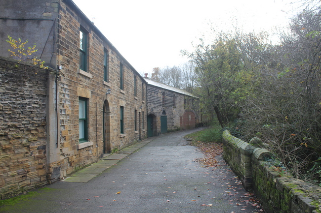
Below - The row along the north of the workshop site.

Below - Some of the later buildings have been covered with murals.

Below - The buildings along the south of the workshop site.


Below - Outside the works site the curved wall at the southern edge of the works which can be seen on the old map.


Below - Remnants of the building seen to the south of the workshop on the old map.

Below - Early ironwork remains to the east of the site.

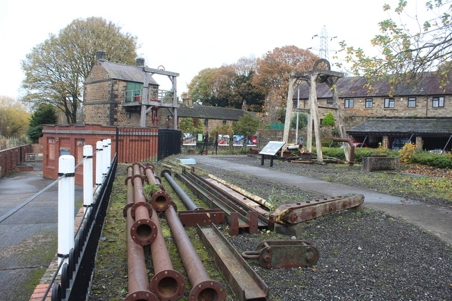
Below - The former engine sheds of the heritage railway.

Below - Site of the heritage railway. The walls of part of the ironworks can be seen behind.


Below - The last two items of stock left from the railway, Thomas Hill shunter 138C and a Great Western brake van at the level crossing with Distillery Side.


Below - The former entrance to the railway to the right of the sign. Left of the sign is a footpath that follows another old incline, this was already removed when the old maps available where published.

Below - The 1795 Newcomen Engine and Air Shaft. The steam engine is still in situ in the engine house, the oldest steam engine in the world still in its original location. The later brick building next to the Newcomen Engine house was for later pumping machinery which had to be kept operational until all mining in the area had finished. The houses in the background are those of Distillery Row shown on the old map.
Below - Information board at the Air Shaft. The small set of concrete head gear would have been for lowering and removing equipment and materials for maintenance reasons.

Below - The business end of a Newcomen Engine with the pump rod descending in to the shaft.

Below - The Newcomen Engine house seen across the abandoned heritage railway.

Below - Information board at the Newcomen Engine.

Below - Compressed air receiver at the back of the Newcomen Engine house.

Below - The various buildings at the back of the Newcomen Engine house, the boilers would have originally have been in this location.

Below - Looking along the railway line towards the heritage centre.

Below - Looking along the railway towards Cortonwood where it met the MS&LR (later Great Central Railway) mainline.

From the heritage centre there is a foot and cycle path to Cortonwood and Wath that forms part of the Transpennine Trail, this follows the course of the Dearne & Dove Canal which runs alongside the former railway.
Below - The former Elsecar Mill corn mill seen across the canal.

Below - Remnants of the footbridge that took workers across the canal to Simon Wood Colliery.

Below - Partly restored canal lock.

Below - Information board next to the canal lock, the old picture shows Simon Wood Colliery in the background.

Below - Another information board next to the canal.

Below - The canal reduced to a stream. In the background the brickwork can be seen of the wharf that stood at the foot of the incline from Jump and Hoyland Silkstone Collieries. I will come to this incline later, though the wharf site is now private land.

Below - Remains of the canal basins for Hemmingfield Colliery.


Below - Information board at the Hemmingfield Colliery basin.

Below - Hemmingfield Colliery

Below - Fixed distant signal on the railway. Note the early engine house at the colliery site.

Below - Hemmingfield Colliery seen from Wath Road (these pictures were actually taken on a seperate trip a few days previously).


Below - The old engine house at Hemmingfield Colliery, seemingly being converted to a house.

Below - Tingle Bridge level crossing with remnants of crossing barriers.

Below - The remains of the canal and towpath looking towards Cortonwood.

Below - Remains of a lock on the canal.

Below - Smithy Bridge.

Below - The railway line looking towards Wath from Smithy Bridge crossing. Though work was carried out to extend the railway towards Cortonwood, the section beyond Smithy Bridge crossing never opened to the public.

Below - At Cortonwood there was a fenced compound at what would have been the northern terminus of the heritage railway.

Below - The end of the heriatge railway with what looks to have been some children's playground equipment built next to what would have been the station site.

The path comes out on to the Cortonwood Roundabout which serves the Cortonwood Retail Park that occupies the former colliery site. This made for a handy refreshment stop but any trace of the mining history has been obliterated by the redevelopment. The footpath continues alongside the A6195 to the site of the junction with the mainline at Wath yard, though again there has been extensive redevelopment since the mines closed. I returned to Elsecar by the same path alongside the canal, this time leaving the canal at Wath Road.
Below - Old workers' houses on Wath Road showing two distinct grades of housing.

Some traces of the route of the incline from the canal to Jump and Hoyland Silkstone Collieries survive. As mentioned earlier, the site of the Wharf on the canal is now private land. Welland Crescent is built on part of the incline. Opposite Welland Crescent a footpath runs at the back of Oakenroyd Croft following the course of the incline.
Below - Where the Midland Railway route crossed over the incline.

Vizard Road is built alongside the former incline and beyond here it is all landscaped over and built on. I therefore returned to Elsecar station for a train home.
No comments:
Post a Comment