A circular walk from Holyhead station to Holyhead Breakwater Country Park and Holyhead Breakwater Lighthouse. Distance 8 Miles.
The breakwater at Holyhead is the largest breakwater in the United Kingdom. Built from the 1840s to coincide with the railway line from Chester reaching Holyhead in 1848. Prior to the construction of the breakwater ships would sometimes have to be diverted to a small harbour on the south side of Anglesea in the event of strong northerly winds. At the time Britain ruled the whole of the island of Ireland and improving transport links between London and Dublin had long been seen as vital to cementing Britain's rule over Ireland.
Millions of tons of stone were used in the project from hills west of Holyhead. To facilitate the construction work a 7ft gauge broad gauge railway was built from the quarry to the breakwater and to Salt Island at the heart of the port. 7ft gauge is well known as the broad gauge favoured by Brunel for the Great Western Railway. It was also a popular gauge for systems that used rail mounted cranes due to the greater stability. In this instance hopper wagons were used that dropped stones between the rails, the wider gauge allowing larger stones to be dropped.
I started at Holyhead station where since 1848 passengers have been connecting between the trains and ferries to Ireland. Originally the ferries docked next to the station but like many ports the larger modern ferries now dock further out. The ferries now dock on what the old maps show as Salt Island. Holyhead has an unusual V shaped station with the Inner Harbour between the two sets of platforms either side.
Below - Platform 1 of Holyhead station. Platform 1 originally had an overall roof similar to Platform 2 but this was removed when the ferry terminal was modernised. The building below allowed passengers off trains from London easy access to the ferries to Ireland that would dock alongside.
Below - The Inner Harbour where ferries for Ireland would dock alongside the railway station. At a newer passenger terminal just beyond the end of Platform 2 ferry passengers now transfer to a bus that takes them on to the ferry. Low bridges across the entrance to the Inner Harbour now block shipping from using this part of the harbour. Platform 1 can be seen on the right and the overall roof of platform 2 on the left. Between the two Stena Line's offices now occupies the site of the old Station Hotel.
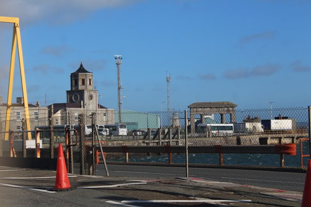
I followed Victoria Road / the A5154 to the corner with Prince of Wales Road. The road from the terminal next to the station to where the ships dock is fenced off but some of the old warehouse buildings of Marine Yard and a few buildings of the old harbour can be seen through the fence.
Below - The old Customs House, Harbour Office and George IV Arch seen through the fence of the port complex. The George IV arch was built to bookend the coach route from London with the Marble Arch.
The breakwater railway system tends to be remembered as an isolated line that never the less became part of the nationalised British Railways system. As such it gets forgotten that it had a link to the centre of Holyhead with a branch to Salt Island on which the old harbour was established. The rails of the branch from the quarry to Salt Island would have run close to where the lines from the station to the Mail Pier crossed on to Salt Island, though would not have been connected as the lines were built to different gauges. Prince of Wales Road and Beach Road follow the course of the branch from the quarry in to Holyhead.
Below - Map of the railway system used for the breakwater and port construction works that was displayed on information boards at the quarry site.
Below - Illustration of one of the broad gauge locomotives from the displays at the quarry site.
A number of stone sleepers from the railway have been recovered, a row of them has been placed along the north side of Beach Road and the south side of the road to the Holyhead Breakwater Country Park where it leaves Beach Road. This road to the country park follows the old railway trackbed.
Below - Stone sleepers alongside the road to the country park where it leaves Beach Road.
The trackbed was well engineered for a contractor's railway, after leaving Beach Road there is a section of embankment with a couple of bridges.
Below - The bridge over Porth Y Fellin Road.
Below - A bridge over a footpath, beyond it the former trackbed can be seen entering a cutting.
Below - Looking back towards Holyhead through the cutting.
In the triangle between the lines from the quarry to the breakwater and Salt Island was the works buildings.
Below - Old sign for the Works Entrance on the gate to the works site off the road along the former Salt Island line.
Below - The works building. In later years this was home to BR's entire 01 class locomotive fleet, both of them. The rails can still be seen set in to the concrete.
Below - At the back of the works building is what looks to be a loading platforms, this must have been for road carts as the railway was just behind where I'm standing.
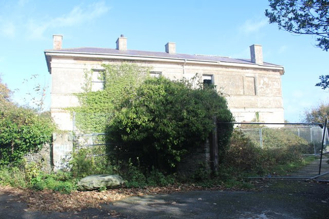
East of the works building are a couple of interesting abandoned buildings. Firstly there is the old Soldiers' Point Hotel. This once grand building was built as a house for Charles Rigby, the chief contractor for the works. More information about the building can be found on the
Coflein website. It also features on the
28 Days Later urban exploration site.
Below - The former Solidiers Point Hotel, originally the chief contractor's house.
Below - The derelict former Porth Y Felin house.
Earlier maps show this as Government House suggesting it was part of the military presence around the harbour.
Below - The walls around Soldiers Point.
Returning to the entrance to the former works I then continued to follow the former trackbed to the quarry which again now forms the road link from Beach Road to the country park in the former quarry site.
Below - One of a couple of bridges over the former railway, this one had lost its span. The holes in the abutment indicate that this likely had a wooden deck.
Below - On the north side of the track one of the former powder houses can be seen. This well built structure is deliberately sited away from the works buildings in the quarry.
Below - The other bridge over the former line, this one still having a deck, though the holes in the abutments suggest the bridge may have also had a wooden deck originally.
Arriving at the former quarry site the pools of water can be seen either side of the roadway. These are the former reservoirs that would have supplied the steam powered machinery on the site. The former overseers house is now a cafe.
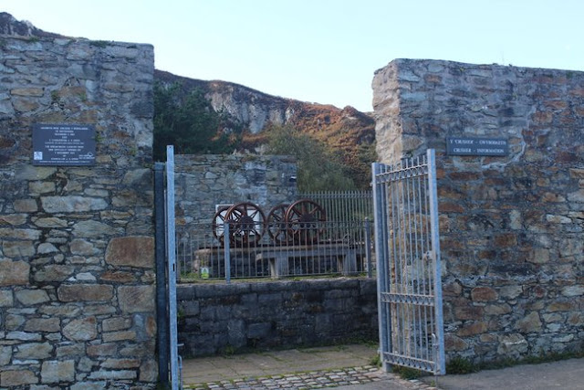
Below - Entrance to the former quarry site with the former overseers house and buildings of the brickworks which in the years after the breakwater construction supplied fire bricks to factories.
Below - In the former brickworks remains of the brick kilns can be seen. The walls are also used to display artworks and old photos of the area.
Below - Information board in the former brickworks site.
To the west of the brickworks site there are remains of another complex of industrial buildings. These include the crushing plant. The old map shows an elevated tramway which linked the cutting face to the building. This has gone now but most of the walls of the building survive and are now used to display information about the site.
Below - The former crusher site with its information displays.
The old maps also show another group of buildings further west. The site of these is now covered with quite prickly vegetations but some walls can be seen sticking up out of the vegetation.
Below - Looking towards the stone face an old incline and working level can be seen. The old map doesn't show track on the incline but it would likely have had a wagonway on it in earlier years to bring stone down to the works in the quarry. A footpath now follows the incline just as it did in 1925 but for some reason the path goes on to the incline diagonally from the east rather than following the incline all the way from the foot of the incline.
Below - A view from the incline. The reservoirs and brickworks can be seen.
Below - The former brickworks and crusher plant seen from the incline.
Returning to the works site for the breakwater I continued on to the breakwater itself.
Below - Gate at the land end of the breakwater with the end of the walls around Soldiers' Point.
Below - An old Sealink sign on the gate. Although it shows it as private it is only vehicles that are prohibited, there is an open pedestrian entrance to the left of the gate. There were a few walkers around this end of the breakwater but no one venturing far as it was quite windy and there were waves breaking over the structure.
Below - Just beyond the gate a short piece to track can be seen where it was concreted in to the roadway to the upper level of the breakwater. The line ran along the lower level, though in earlier years a track was provided on the upper level too.
Below - Looking back towards Soldiers' Point and the quarry from the end of the breakwater. The railway line ran on the left to the lower level. A siding and run round loop also went off to the landing stage on the left.
Below - Looking along the breakwater. The railway ran on the lower level to the right.
Below - Looking along the former rail access on to the breakwater. The small hut shown on the old map can be seen. Lines ran on to the landing stage on the right.
Below - A picture seen in the former brickworks earlier showing the view here in 1959. A rail connection can be seen on to the upper level.
Below - In a couple of spots there is evidence of "baulk road" construction of the railway line with wooden sleepers laid along the underside of the rail and timbers to space these. This was a normal construction technique on broad gauge lines but may have been retained when the lines were regauged in 1913.
Below - Though I did spot one conventional sleeper.
Below - Another view back along the breakwater. Evidence of the little passing loop halfway along the breakwater can be seen.
The zig zag shape of the breakwater was not the original plan, originally it would have continued east and an eastern breakwater would have been built heading north from Salt Island. The plan was changed for the breakwater to curve and head north to enclose a larger area around Salt Island.
Below - Looking back along the breakwater with remains of some kind of metal structure. Parallel to the wall a mark can be seen on the ground from a rail that carried a travelling crane built by William Arrol. It had one side on the upper level and one side on the lower level with a rail running along each level.
Below - The end of the breakwater railway with the baulk timbers still in place. The lighthouse at the end of the breakwater was of square construction to give rooms for the crew within the tower.
Below - Looking back at the end of the railway from the top of the building sticking out from the upper level. On the left the turning circle added to the breakwater can be seen, this allowed road based plant equipment to replace the railway in 1981. The two locomotives were scrapped at their shed the following year.
Below - The building at the end of the railway shown on the old map and another look at the turning circle added for road vehicles.
Below - A closer look at the lighthouse. A gun was once kept on the left to protect the harbour from vessels arriving from the Irish Sea.
The
Railways of North Wales 1975 -1983 has a page about the breakwater railway in its later years with some photos including shots of one of the class 01 shunters in action.
Rail Express Magazine also produced a
Class 01 Story feature with a picture showing the train next to the crane.
.JPG)
.JPG)
.JPG)
.JPG)
.JPG)
.JPG)
.JPG)
.JPG)
.JPG)
.JPG)
.JPG)
.JPG)
.JPG)
.JPG)
.JPG)
.JPG)
.JPG)
.JPG)


