Starting Point - Chester Le Street station. Finishing Point - South Hylton station. Distance 10.8 Miles.
Google Maps (Leg 1 - Chester Le Street to Washington.)
County Durham has a few old railways that survived as freight routes beyond the Beeching closures before closing in the 1980s and 90s due to the downturn in the industries they served. This has resulted in some routes being more intact than others that have been closed for longer. Some sections of route have been proposed for reopening as passenger lines or Tyne and Wear Metro extensions. While it would be a nice to think I could go back and ride on a line I'd walked as a disused line such schemes do tend to just keep civil servants and consultants busy for a few years before getting cancelled as there's no money for actually constructing stuff.
This route from Chester Le Street to South Hylton has three legs taking in a few different routes. From Chester Le Street I take the former Pontop & South Shields Branch to Washington. At Washington it met the Leamside Line which has only recently been lifted, it was only lifted to stop metal thieves lifting it first as there have been a few proposals to reopen the route. With the Leamside Line route safeguarded for possible reopening it is not a footpath so for the next leg I headed across the River Wear to the site of Painshaw station, taking in a couple of wagonways that served staithes on the river. From Penshaw I followed the former Painshaw Branch to the site of Hylton Station, just across the road from South Hylton station on the Tyne & Wear Metro which has revived part of the route.
I took a train to Chester Le Street and walked to the Wheatsheaf Inn on Durham Road. This was the site of Beamish Junction where the line from Washington fanned out to various lines that transported coal and limestone to the River Tyne and served the huge steelworks at Consett.
Chester Le Street Durham Turnpike
The Wheatsheaf Inn is shown on the old map. I had done some of the routes further west from here so today I headed east to Washington. The origins of the route go back to various early waggonways that were adapted over the years to suit steam locomotive use rather than horses and incline sections.
More about the Pontop & South Shields Railway can be found on the Wikipedia article.
Below - Former railway bridge over Durham Road


There are references to a station in the vicinity known as Chester Le Street Durham Turnpike but I couldn't see it shown on any the old maps so presumably it was short lived. It seems any passenger service between Chester Le Street and Washington had finished by 1853 after which the line was entirely a freight route.
Vigo
Again mention is made of a short lived station here that seems to have fallen out of passenger use by 1853.
Below - Former bridge over railway at Vigo.


Below - Bridge under the A1(M). This has been reinforced to take heavier road vehicles since the railway closed.

Below - Picktree Lane bridge. This was constructed more recently than any of the available maps show.


Below - Former railway bridge over the A182.

Biddick Lane
The path crosses Biddick Lane on the level just as the old line did as shown on the old map. This is mentioned as being the site of another short lived passenger station and some of the buildings shown around the crossing on the above map look like they might be remnants of this station. The area is surrounded by modern housing development and nothing remains of the station.
Washington
Approaching Washington the line met the Leamside Line. The Leamside Line was the original East Coast Main Line until services were diverted via Chester Le Street in 1872. The Leamside Line retained its local passenger services until 1964. It was mothballed in the 1990s, the last use it saw was diverted mainline services when the mainline was electrified. There has been regular talk of re opening the route to relieve the East Coast Mainline but track was lifted in the 2000s after attacks by metal thieves. Approaching the former junction with the Leamside Line a path curving off to the right crosses the former line. Plenty of ballast can still be seen on the trackbed due to its reletively recent lifting.
Below - Former Leamside line looking south towards the Victoria Viaduct

Where the line from Chester Le Street met the Leamside Line at Washington South Junction it is separated from the more recently closed line by a fence. The path emerges on to Pattison Road. The original station for Washington was built at the junction but was replaced as early as 1850 with a new station to the north, the site of which I'll come to shortly. The site of the sidings south of the station is now a fenced off sea of ballast. The footbridge over the sidings survived until quite recently but has been replaced by a fenced path crossing the trackbed on the level.
Below - Location of footbridge across the sidings and line through Washington.


From the site of the footbridge I headed to Station Road along the nearby roads.
Below - Station Road bridge at site of Washington station.

Below - Site of Washington station from Station Road.

The trackbed was accessible at the site of Washington station.
Below - Trackbed through the Washington station site.

Below - Retaining wall at the back of the former northbound platform.

Below - Returning to Station Road the site of the road access to the goods shed and southbound platform was situated between the surviving bridge span and the removed span that took the goods lines.

The Leamside Line north to Pelaw is largely fenced off. As it is safeguarded for possible re-opening it can't be turned in to a footpath. I headed to the other side of the River Wear where the former Painshaw Line to South Hylton is now a footpath.
The spectacular Victoria Viaduct is disused but is not open to pedestrians so I crossed the river at Washington Staiths. The path from Wilden Road is on a former wagonway to the staithes. I also walked along the riverside to look for remnants of the staithes and get a better view of the viaduct.
Below - Victoria Viaduct.


Below - Former Low Lambton Drops coal staith.

Below - Former Washington Staiths.

Google maps doesn't show the footpaths that took me to the former Painshaw Branch on the south side of the river but these are shown on Open Street Map . The path has the appearance of a railway embankment as it follows the course of the lines to Low Lambton Drops shown on the old map above.
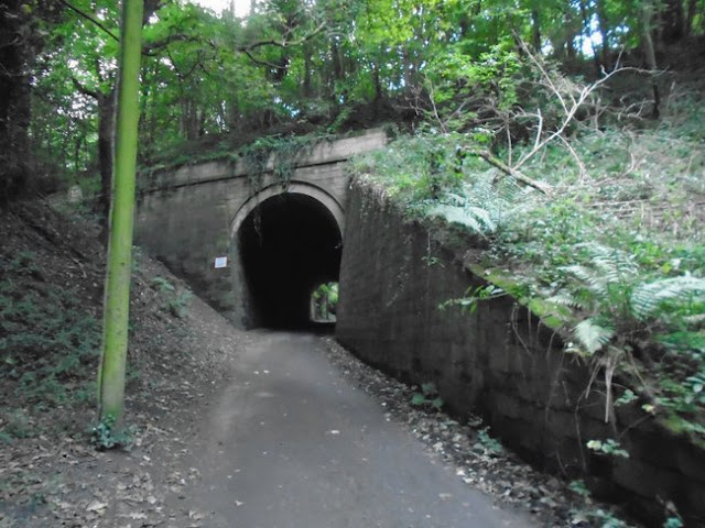
The old map shows a tunnel to a quarry. This and a couple of other tunnels can be seen. These would have had narrow gauge waggonways to bring stone from the quarry to the river.
Below - Former tunnel to Low Lambton Quarries.

Below - A look along the footpath on the former Low Lambton Wagonway.

Below - Another former tunnel to Low Lambton Quarries.

Where the line meets the farm track for Low Lambton Farm close to Painshaw Junction the path emerges on to the farm track. The stretch of the Low Lambton wagonway to the junction is now part of the farmland. As shown on the old map the track crosses under the Leamside Line before crossing over the line south of Painshaw Junction.
Below - Former Leamside Line bridge over the farm track to Low Lambton Farm.
Below - Former bridge for track to Low Lambton Farm over lines through Penshaw.

Below - Former Leamside line through Penshaw.

Below - Former Leamside line and farm track bridge.

With the Penshaw Branch now being a footpath the trackbed is accessible. There is also very little in the way of fencing between the parallel Penshaw and Leamside routes. I continued west to the site of Penshaw Station.
Penshaw
Variously referred to as Penshaw or Painshaw or even Pensher, more about the station can be found on the Wikipedia article. More information about the station and various routes in the area can be found on the
Below - Bridge over Station Road.

Below - Site of Penshaw station.

Below - Site of sidings and junction with Lambton Railway going off on the left where the new houses now stand.

From the site of Penshaw station I headed east on the former Penshaw Branch, now a footpath, to South Hylton.
Google Maps (Leg 3 - Penshaw Station to Hylton Station)
One of the reopening schemes would see a new chord to extend the Tyne and Wear Metro line from South Hylton on to the Victoria Viaduct and in to Washington. If that were to happen the following section I follow could end up becoming a Metro line.
Below - Former Penshaw branch near Coxgreen Junction.

Below - Penshaw Monument seen from the former railway.

Cox Green
The path crosses the road at the site of Cox Green station. The station master's house survives as a house and more modern buildings have sprung up around the station site.
The bridge carrying Woodhouse Lane over the former railway east of Cox Green survives.
Below - Woodhouse Lane bridge over former Painshaw Branch near Cox Green.

The crossing keeper's cottage also survived next to the crossing shown with a siding on the old map.
Hylton
After crossing under the modern A19 under a bridge shared with Offerton Lane (where it formerly crossed the railway) the trackbed reaches the site of Hylton station. The original station was situated west of Hylton Bank where as the Tyne and Wear Metro station on the reopened section is east of the road. A section of wall at the back of the westbound platform remains.
Below - Remains of original Hylton Station.


From the original station I crossed the road to the Tyne & Wear Metro's South Hylton station and rode the Metro on the revived section of the line to Sunderland for my train home.
No comments:
Post a Comment