BROWSE JOURNEYS BY MAP VIEW

Saturday, 27 August 2022

Tracks Through Washington

Starting Point - Chester Le Street station. Finishing Point - South Hylton station. Distance 10.8 Miles.

Google Maps (Leg 1 - Chester Le Street to Washington.)

County Durham has a few old railways that survived as freight routes beyond the Beeching closures before closing in the 1980s and 90s due to the downturn in the industries they served. This has resulted in some routes being more intact than others that have been closed for longer. Some sections of route have been proposed for reopening as passenger lines or Tyne and Wear Metro extensions. While it would be a nice to think I could go back and ride on a line I'd walked as a disused line such schemes do tend to just keep civil servants and consultants busy for a few years before getting cancelled as there's no money for actually constructing stuff.
This route from Chester Le Street to South Hylton has three legs taking in a few different routes. From Chester Le Street I take the former Pontop & South Shields Branch to Washington. At Washington it met the Leamside Line which has only recently been lifted, it was only lifted to stop metal thieves lifting it first as there have been a few proposals to reopen the route. With the Leamside Line route safeguarded for possible reopening it is not a footpath so for the next leg I headed across the River Wear to the site of Painshaw station, taking in a couple of wagonways that served staithes on the river. From Penshaw I followed the former Painshaw Branch to the site of Hylton Station, just across the road from South Hylton station on the Tyne & Wear Metro which has revived part of the route.

I took a train to Chester Le Street and walked to the Wheatsheaf Inn on Durham Road. This was the site of Beamish Junction where the line from Washington fanned out to various lines that transported coal and limestone to the River Tyne and served the huge steelworks at Consett. 

Chester Le Street Durham Turnpike


The Wheatsheaf Inn is shown on the old map. I had done some of the routes further west from here so today I headed east to Washington. The origins of the route go back to various early waggonways that were adapted over the years to suit steam locomotive use rather than horses and incline sections.

More about the Pontop & South Shields Railway can be found on the Wikipedia article.

Below - Former railway bridge over Durham Road


There are references to a station in the vicinity known as Chester Le Street Durham Turnpike but I couldn't see it shown on any the old maps so presumably it was short lived. It seems any passenger service between Chester Le Street and Washington had finished by 1853 after which the line was entirely a freight route. 

Vigo

Again mention is made of a short lived station here that seems to have fallen out of passenger use by 1853.

Below - Former bridge over railway at Vigo.


Below - Bridge  under the A1(M). This has been reinforced to take heavier road vehicles since the railway closed.


Below - Picktree Lane bridge. This was constructed more recently than any of the available maps show.


Below - Former railway bridge over the A182.


Biddick Lane


The path crosses Biddick Lane on the level just as the old line did as shown on the old map. This is mentioned as being the site of another short lived passenger station and some of the buildings shown around the crossing on the above map look like they might be remnants of this station. The area is surrounded by modern housing development and nothing remains of the station.

Washington

Approaching Washington the line met the Leamside Line. The Leamside Line was the original East Coast Main Line until services were diverted via Chester Le Street in 1872. The Leamside Line retained its local passenger services until 1964. It was mothballed in the 1990s, the last use it saw was diverted mainline services when the mainline was electrified. There has been regular talk of re opening the route to relieve the East Coast Mainline but track was lifted in the 2000s after attacks by metal thieves. Approaching the former junction with the Leamside Line a path curving off to the right crosses the former line. Plenty of ballast can still be seen on the trackbed due to its reletively recent lifting.

Below - Former Leamside line looking south towards the Victoria Viaduct


Where the line from Chester Le Street met the Leamside Line at Washington South Junction it is separated from the more recently closed line by a fence. The path emerges on to Pattison Road. The original station for Washington was built at the junction but was replaced as early as 1850 with a new station to the north, the site of which I'll come to shortly. The site of the sidings south of the station is now a fenced off sea of ballast. The footbridge over the sidings survived until quite recently but has been replaced by a fenced path crossing the trackbed on the level.

Below - Location of footbridge across the sidings and line through Washington.


From the site of the footbridge I headed to Station Road along the nearby roads.

Below - Station Road bridge at site of Washington station.


Below - Site of Washington station from Station Road.

The trackbed was accessible at the site of Washington station.

Below - Trackbed through the Washington station site.


Below - Retaining wall at the back of the former northbound platform.


Below - Returning to Station Road the site of the road access to the goods shed and southbound platform was situated between the surviving bridge span and the removed span that took the goods lines.


The Leamside Line north to Pelaw is largely fenced off. As it is safeguarded for possible re-opening it can't be turned in to a footpath. I headed to the other side of the River Wear where the former Painshaw Line to South Hylton is now a footpath.
The spectacular Victoria Viaduct is disused but is not open to pedestrians so I crossed the river at Washington Staiths. The path from Wilden Road is on a former wagonway to the staithes. I also walked along the riverside to look for remnants of the staithes and get a better view of the viaduct.

Below - Victoria Viaduct.


Below - Former Low Lambton Drops coal staith.


Below - Former Washington Staiths.


Google maps doesn't show the footpaths that took me to the former Painshaw Branch on the south side of the river but these are shown on Open Street Map . The path has the appearance of a railway embankment as it follows the course of the lines to Low Lambton Drops shown on the old map above.
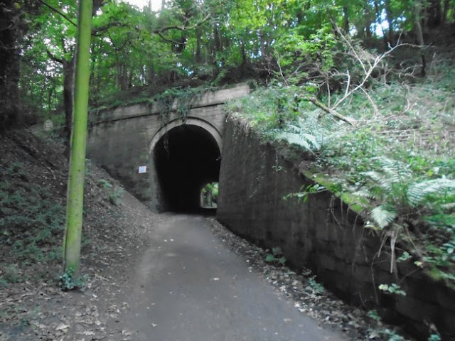
The old map shows a tunnel to a quarry. This and a couple of other tunnels can be seen. These would have had narrow gauge waggonways to bring stone from the quarry to the river.

Below - Former tunnel to Low Lambton Quarries.


Below - A look along the footpath on the former Low Lambton Wagonway.


Below - Another former tunnel to Low Lambton Quarries.


Where the line meets the farm track for Low Lambton Farm close to Painshaw Junction the path emerges on to the farm track. The stretch of the Low Lambton wagonway to the junction is now part of the farmland. As shown on the old map the track crosses under the Leamside Line before crossing over the line south of Painshaw Junction.

Below - Former Leamside Line bridge over the farm track to Low Lambton Farm.


Below - Former bridge for track to Low Lambton Farm over lines through Penshaw.


Below - Former Leamside line through Penshaw.


Below - Former Leamside line and farm track bridge.


With the Penshaw Branch now being a footpath the trackbed is accessible. There is also very little in the way of fencing between the parallel Penshaw and Leamside routes. I continued west to the site of Penshaw Station.

Penshaw

Variously referred to as Penshaw or Painshaw or even Pensher, more about the station can be found on the Wikipedia article. More information about the station and various routes in the area can be found on the 

Below - Bridge over Station Road.


Below - Site of Penshaw station.


Below - Site of sidings and junction with Lambton Railway going off on the left where the new houses now stand.


From the site of Penshaw station I headed east on the former Penshaw Branch, now a footpath, to South Hylton.

Google Maps (Leg 3 - Penshaw Station to Hylton Station)

One of the reopening schemes would see a new chord to extend the Tyne and Wear Metro line from South Hylton on to the Victoria Viaduct and in to Washington. If that were to happen the following section I follow could end up becoming a Metro line.

Below - Former Penshaw branch near Coxgreen Junction.


Below - Penshaw Monument seen from the former railway.


Cox Green


The path crosses the road at the site of Cox Green station. The station master's house survives as a house and more modern buildings have sprung up around the station site.


The bridge carrying Woodhouse Lane over the former railway east of Cox Green survives.

Below - Woodhouse Lane bridge over former Painshaw Branch near Cox Green.


The crossing keeper's cottage also survived next to the crossing shown with a siding on the old map.

Hylton 


After crossing under the modern A19 under a bridge shared with Offerton Lane (where it formerly crossed the railway) the trackbed reaches the site of Hylton station. The original station was situated west of Hylton Bank where as the Tyne and Wear Metro station on the reopened section is east of the road. A section of wall at the back of the westbound platform remains.

Below - Remains of original Hylton Station.


 From the original station I crossed the road to the Tyne & Wear Metro's South Hylton station and rode the Metro on the revived section of the line to Sunderland for my train home.

Saturday, 20 August 2022

Afan Valley Lines

A round trip from Port Talbot Parkway station to Efail-fach, Abergwynfi and Glyncorrwyg. 
Distance 34.8 Miles

The Afan Valley in South Wales has become well known for its cycle trails and many of these are former railway lines. I took my bike to Port Talbot Parkway station and cycled many of the former railway routes along the valley.

Note - the suggested route on the Google Map link doesn't always follow the cycle routes shown that were built on the former railway routes. I tried to stick to the railway routes as closely as possible.


Port Talbot Central

I started with the Port Talbot Railway's Blaenavon Branch (in red on Rail Map Online). A connection to the docks once existed but this is shown as severed next to Port Talbot Central station on the 1917 map and removed completely on the 1947 map. The Port Talbot Railway's Port Talbot Central station was closed in 1933 and the area has been built on since. It was necessary to follow the roads to King Street and under the M4. The M4 occupies a stretch of former Port Talbot Railway trackbed around the town.
The cycle route is picked up on Yns y Gored close to the Margret Street Bridge, this stretch follows the trackbed to Cwmafan as it follows along the east side of the River Afan 


At Cwmafan the path emerges on to London Row on the footbridge shown on the old map. Across London Row the path follows the course of the Rhondda & Swansea Bay Railway through Cwmafan with a bit of diversion around the Rugby Club built on the site.

Cwmavon


The Port Talbot Railway is accessed again east of Cwmafan off the bridge over the River Afan at the end of Heol Undeb. This bridge is on the site of an old tramway shown towards the bottom right on the above map. The cycle route is known as National Cycle Network route 887 at this point.


Pontrhydyfen

The cycle path continues along the Port Talbot line up to Efail-fach on a stretch now known as the Richard Burton Trail. It passes over Pontrhydyfen on a viaduct and emerges on to the B4287 at Efail-fach where it used to cross on a bridge, the abutments of which survive. 

Below - Pontrhydyfen Viaduct

I returned to the site of the junction between the Port Talbot Railway and the Rhondda and Swansea Bay Railway south of Pontrhydyfen. This has been largely built on through the village and National Cycle Network route 887 follows the roads. The cycle route also includes the Pontrhydyfen Aquaduct, originally built to supply water to an iron works.

Below - View of the Pontrhydyfen Viaduct  I crossed earlier from the Aquaduct.

Below - View of the Port Talbot to Treherbert line from Pontrhydyfen Aquaduct, the abutments of the missing bridge over the river can be seen.

The railway is accessed again from the Rhyslyn Car park built on the site of Pontrhydyfen station. It was also the site of a junction with a link to the South Wales Mineral Railway which I will come to later, in the mean time I follow the former Rhondda & Swansea Bay Railway line running along the south side of the river. The cycle route crosses on a modern bridge built on the abutments of the old railway bridge.

Cynonville Halt

1918 Map  

 Below - Cynonville Halt 


Close to the former Cynonville Halt station is the South Wales Miners Museum which is well worth a stop off.

Below - South Wales Miners Museum


1946 Map 

Cymmer

1899 Map

Shortly before Cymmer station a connection was made with the line to Maesteg as it emerged from Cymmer Tunnel. a metal viaduct also took the line across the valley to meet the South Wales Mineral Railway on the north side of the valley. Bridges of this type were once commonplace across the South Wales valleys but were mostly removed after closure of the lines, either for safety reasons or to scrap the metal. Fortunately this viaduct survives, although the deck has been removed so it is not possible to cross the viaduct.

Below - Cymmer Viaduct


The station at Cymmer also survives and is now a cafe known as the Refreshment Rooms so it makes another handy pit stop on the journey.

Below - former Cymmer Station


There were actually two parallel stations here, Cymmer Afan on the Rhondda and Swansea Bay Railway from which the above building originates and Cymmer General on the Llynfi Branch alongside to the south where the fire station now stands. These were formally amalgamated in 1950 under British Railways.

I continued to Abergwnfi. The R&SBR and the Llynfi branch ran pretty much parallel to each other as single track branches. The cycle route follows the latter route.

Blaengwnfi

1918 Map 

1920 Map 

Shortly before Abergwnfi the R&SBR route diverges to the north. After Blaengwnfi station it went in to Rhondda Tunnel, emerging at Blaencwm near Treherbert. The west portal of the tunnel was buried and nothing remains of the station site. There is a scheme to unearth the tunnel portal and reopen the tunnel as a cycle route. This would be a great attraction in its own right if it is reopened as well as improving access to the cycle routes from the Treherbert direction which can also be reached by train.

Rhondda Tunnel Society website

Abergwnfi

The Llynfi branch terminated in a station on Station Road, though lines continued east to various mines in the area. Nothing remains of the station.

 1918 Map

I returned to Cymmer but this time crossed the River Afan to reach the Afan Valley Cycle Way on Railway Terrace. This follows the South Wales Mineral Railway.

South Wales Mineral Railway Wikipedia page

1899 Map

Glyncorrwg

I began by following the route north to Glyncorrwg, though this was a pleasant scenic ride there was little to see of the railway and mining history of the area now. Returning to Cymmer I headed west along the former South Wales Mineral Railway.

 Below - Cymmer Viaduct seen from the north side where it connected to the South Wales Mineral Railway.

The section of route that now forms the Afan Valley Cycle Way contains some section of quite steep rock cut cutting. It can be appreciated that the line was originally built to Brunel's broad gauge.

Below - Cutting on the South Wales Mineral Railway


As the route passes Cynonville on the other side of the valley the path splits, the route to the right accesses the Afan Bike Park. Originally this route went in to the Gyfylchi Tunnel, though the collapse of the tunnel in 1947 led to the closure of that section of the route.
The path diverging on the left followed the Rhondda & Swansea Bay Railway link to Pontrhydyfen mentioned earlier. I followed this back to Pontrhydyfen.
I retraced my route to Cwmafan. As mentioned earlier the cycle route through Cwmafan follows the Rhondda & Swansea Bay Railway. Rather than return to the former Port Talbot Railway I followed the R&SBR in to Port Talbot. 


From London Row a stretch of path runs to the B4286. This follows the course of the railway before diverting around the Trefelin Boys and Girls Club and emerging on to the B4286. The railway ran alongside the road to the east, though the road has been widened in places. Shortly after joining the B4286 the cycle route runs separately to the east in to Port Talbot.


Before passing under the motorway again the line crossed the River Afan on Velindre Bridge, this still survives and carries the cycle route, though once under the motorway it emerges in to a Tesco supermarket.


The line had a triangular junction with the main line that survives to this day and a line straight ahead to the docks. This has all been lost under modern retail development. I returned to where I started at Port Talbot Parkway station.

Saturday, 13 August 2022

Aberthaw Lime Works

A short walk at the Aberthaw Nature Reserve

At Aberthaw, west of Rhoose in South Wales, are the remains of Aberthaw Lime Works. This operated from 1888 and 1926. Aberthaw Lime was made famous when it was tested by John Smeaton and found to have properties where it would set under seawater. This made it ideal for projects such as his Eddystone Lighthouse (though that used lime made in Watchet from stone shipped across the nearby Bristol channel). It was also ideal for construction of docks and similar infrastructure projects.


Aberthaw was ideally situated as the lime was quarried locally and coal could be easily supplied from the countless collieries of the nearby South Wales valleys. A connection to the Taff Vale Railway's Aberthaw branch brought in the coal and a tramway brought in stone from the quarries to the east of the works.
More information about the works can be found on the Wikipedia article.

The site is now located in a nature reserve just off the Wales Coastal Path. It features a pair of kilns which would have been charged at the top and unloaded at the side. There is also a chimney and the walls of a building that would have housed machinery between the two sets of kilns.

Below - The complex seen from the east. The old map above shows the kiln building on the left and machinery building in the middle but the other kiln building on the right that is now covered in ivy appears to be a later addition.


Below - The passage between kilns on the left and the machinery building on the right.


Below - This is where the later set of kilns would be discharged. A set of rails would have allowed the kilns to be discharged in to a wagon that could be tipped in to a mainline wagon alongside the kilns.


Below - The roofless remains of the machinery building which would also have housed the works offices.


Below - Inside the machinery building, it can be seen that it had three floors.


Below - Bearing for a line shaft


Below - A water or steam pipe connection.


Below - An out building on the east wall looks like it may have been a boiler house for the engine that would have worked the machinery.


Below - Tunnels remain in the original pair of kilns where the kilns would have been discharged. The lime would have been manually handled out of the building. The workers would have been well covered as the lime would have acted as an irritant. The tunnels would have been a very unpleasant environment.


Below - The complex seen from the south showing the tunnels to the bottom of the kilns.
 

Below - Site of the connection to the Taff Vale Railway.


The Taff Vale Railway trackbed can be followed until it meets the Vale of Glamorgan Line, originally the Vale of Glamorgan line crossed over the Taff Vale Line on a bridge that still exists, however a later line in to the now closed Aberthaw power station cuts across the route without a bridge. The former trackbed is now a footpath in the woods but with nothing to see of the Taff Vale Railway's Aberthaw station (later known as Aberthaw Low Level) it is hard to believe that the woodland footpath was once a railway line.
A bridge under the Vale of Glamorgan line to Well Road and one over the line to Fontygary Road cross the existing line. The former Aberthaw High Level station and signal box can still be seen but though the line had passenger services reinstated in 2005 it was only the intermediate stations at Rhoose and Llantwit Major that reopened.