Starting Point - Manchester Victoria station. Circular Walk of Manchester's main stations. Distance 3.6 Miles.
Below - Railway Clearing House map from 1910 (from Wikipedia)
Manchester's passenger railway stations form a ring around the city centre. I started at Victoria and walked to Picadilly but will start with Picadilly for my account of my visit to the various station sites.
Travis Street
Manchester is well known for being one end of the first Intercity passenger railway, the Liverpool and Manchester (I will come to this later). The first line to head south though was the Manchester and Birmingham Railway a decade later. In 1840 it operated from a temporary station on Travis Street while land was cleared and the Store Street terminus was constructed. Travis Street itself now runs beneath the viaduct on top of which the existing station now sits.
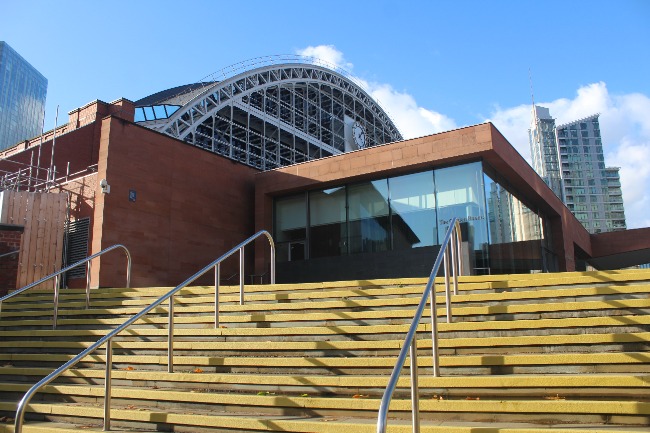
Picadilly / London Road / Store Street
Opened in 1842 as Store Street and renamed in 1847 as London Road and in 1960 as Picadilly, the station has been the main station for Manchester since it opened. London & North Western Railway services from London terminated here as well as services from the Great Central Railway. From 1849 through platforms were added to the south of station for local services of the Manchester South Junction & Altrincham Railway. In the 1960s British Rail extensively modernised the station with the intention of concentrating services on it with the electrification of the former L&NWR route from London. The
Mayfield
Another addition around the then London Road station was an additional L&NWR station south of the main station from 1910 called Mayfield. This was built as a relief to London Road and mainly handled suburban traffic. It closed as a passenger station in 1960 and continued in use as a parcel depot until 1986. A parcels bridge crossed over the station throat at Picadilly to a sorting office nearby. The former sorting office is now an office building and the site of the bridge is now a large window.
On the former station building the site of a since bricked up entrance from a covered passenger footbridge from Picadilly can still be seen.
Below - The building of the former Mayfield station, the former footbridge entrance from Picadilly is in the middle of the left hand side.
Below - A view of the south side of the station, a new public park occupies land south of the station previously occupied by warehousing. The station is being turned into a complex of bars, restaurants and arts facilities.
Below - The station building seen from the south.
Oxford Road
Wikipedia article about Manchester Oxford Road
1922 Map
Oxford Road is on the former MSJ&AR and first opened in 1849. It was extensively rebuilt in 1960 featuring wooden beam structures designed to add little weight to the viaduct on which it sits.
Deansgate / Knott Mill
Also opened in 1849 with the MSJ&AR was Knott Mill. This station avoided 1960s modernisation, it's entrance building dates back to 1896. The building still carries the Knott Mill name above the entrance supplemented by the Deansgate name it gained around 1900 on a modern metal sign.
Central / Free Trade Hall
The Cheshire Lines Committee was a joint operation of the Manchester Sheffield and Lincolnshire Railway (later Great Central), Great Northern Railway and Midland Railway to break the L&NWR monopoly on key routes in the area.
In 1877 they began operating a service from Manchester Free Trade Hall to Liverpool Brunswick. Free Trade Hall was a temporary two platform terminus while their grand Central station was built. When Manchester Central opened in 1880 the Free Trade Hall station site was used for Manchester Central Goods station.
Manchester Central became the terminus of the Midland Railway services from London St Pancras. When BR electrified the L&NWR route from London Euston to Manchester the former Midland route was closed between Matlock and Buxton together with the line from Cheadle Heath near Stockport to Manchester Central.
Below - The arched roof of Manchester Central station. Since closure of the station in 1969 it has become a conference center. The Metrolink tram line now runs past the former station.
Below - Metrolink tram passing the former Central station.
The site of the station entrance, now the entrance to the Manchester Central conference center.
Below - The Midland Hotel built by the railway company to serve the station opposite.
Below - The former approach to the station.
Below - Central station seen from the corner of Watson Street and Great Bridgewater Street.
Below - Alongside the passenger station the viaducts along Watson Lane carried the original Free Trade Hall temporary terminus and later the goods sheds.
Great Northern Goods
Alongside Central station the GNR built it's own large goods warehouse which survives to this day as a complex of bars and restaurants, cinema and multi storey car park.
Below - The former goods warehouse as seen from the north.
Below - The entrance to the goods yard from Deansgate. At the top of the arches are names of destinations served by the Great Northern Railway.
Below - Multi storey car park entrance built on to the former warehouse.
The GNR goods warehouse was served by the Castlefield Viaduct, a two track metal viaduct built alongside the original lines in 1892 to increase capacity.
Below - Where the lines from the Castlefield Viaduct to the GNR Goods station crossed Bridgewater Street.
Below - The start of the metal spans of the Castlefield Viaduct crossing the former MSJ&AR line in to Deansgate.
The Castlefield Viaduct closed in 1969 along with Central station and the goods warehouse. Since closure it has been left abandoned, though the earlier viaduct alongside has been reused by the Metrolink tram line. In 2022 it was partly turned in to a garden by the National Trust.
Below - The remains of a signal can be seen above.
Below - A view from the viaduct showing the MSJ&AR lines, Liverpool Road warehouses and Ordsal Chord bridge.
Below - The park established on the viaduct.
Below - The remaining section of viaduct left as abandoned.
Liverpool Road
The first station in Manchester was Liverpool Road station for the Liverpool and Manchester Railway in 1830. Today the station and goods warehouses house the Manchester Museum of Science and Industry.
Below - The main station buildings, this was the passenger entrance to the departure platform. At ground floor level it housed offices for the station staff, at first floor it was open on the railway side and had a canopy covering the wooden platform.
Below - An existing house that was incorporated into the station building.
Below - Arriving passengers disembarked on the other side of Water Street, this is where they emerged to street level.
Below - The bridge carrying tracks to the goods sheds crossing Water Street.
Below - Road entrance to the 1830 warehouses alongside the station.
Below - The exit from the arrivals platform and Water Street bridge. The bridge was originally more decorative with fluted columns at the pavement edges, the location of these is marked in the paving.
Below - The pig ramp used to herd livestock to and from rail level. Above it is the bridge of the Ordsall Chord, built recently to "revolutionise" train travel around Manchester but without thought in to capacity through Oxford Road. Services over it have since been cut back to hourly.
Liverpool Road was short lived as a passenger station, in 1844 passenger facilities moved to Victoria station and the site at Liverpool Road remained in use as a goods depot. The Liverpool and Manchester Railway became part of the L&NWR.
Exchange
I returned to the road named Deansgate and walked north to the site of Manchester Exchange station.
The London & North Western Railway's Manchester Exchange station opened in 1884 next to Victoria station which it shared with the Lancaster & Yorkshire Railway. It had three through platforms and two west facing bays under a three arched overall roof. One of the through platforms joined a through platform from Manchester Victoria. With the reorganisation of Manchester's stations in the 1960s it closed in 1969. It remained in use as a car park for many years until recent redevelopment as an office complex.
Below - The old station approach on the bridge now leads to a couple of office blocks rather than the grand facade of the station building.
Below - The arches on to which the station were built survive.
Below - The former approach to the taxi rank on the station.
Below - The bridge over the River Irwell where Manchester Exchange met Manchester Victoria with a shared through platform, the stumps of the glass canopy can be seen on the top of the bridge.
Below - The site of Manchester Exchange (on the left) seen from the west end footbridge at Manchester Victoria.
Victoria
Manchester Victoria dates back to 1844 when the Liverpool & Manchester Railway replaced their Liverpool Road station and the Manchester & Leeds Railway replaced their Oldham Road station with a joint station to allow through trains between Leeds and Liverpool.
Oldham Road also became a goods depot when Victoria opened. The site is redeveloped now but the viaduct approaches can be seen on the south side of lines in and out of Victoria to the east. A stump of the lines has seen recent use for freight trains associated with track upgrades in the area.
The cooperation between the successors to the L&MR and M&LR; the L&NWR and the Lancashire and Yorkshire Railway became strained in later years leading the L&NWR to establish it's own route across the Pennines via Huddersfield.
Below - The 1909 station facade.
Below - A remnant of the original 1844 station. The building was originally single storey with an upper floor added later. It lost its symmetry when the larger station building was added in 1909.
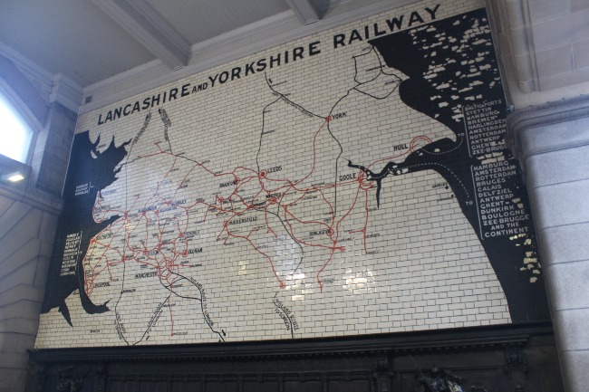
Below - The station's 1909 building still has its L&YR route map, though many of the routes are no longer around.
Below - The ticket office.
Below - The glazed brick sections of building were under the station roof and the plain yellow brick above the roof. The out buildings on the right are remnants of the 1844 buildings. The mosaics show the use off the buildings when the 1909 building was added.
Below - The outline of the roof removed in 2013 can be seen. The remnants of some of the metal girders can be seen in the walls too.
Below - Platform 3 on the right dates back to the 1844 station but the rest of the site to the left was rebuilt between 1992 and 1994 when the Manchester Arena was built above the station. The 1990s rebuild saw what had at its peak been a 17 platform station rebuilt to just 6 platforms (4 through platforms and two east facing bays). When Trans-Pennine services via Huddersfield were subsequently diverted back to Victoria in 2018 when the Ordsall Chord opened chaos ensued.