BROWSE JOURNEYS BY MAP VIEW

Saturday 26 November 2022

Stockport Tiviot Dale to East Didsbury

Starting Point - Stockport station. Finishing Point - East Didsbury station. Distance - 4 Miles

Below - Image found on Facebook post by Manchester History Revealed showing an engineers train emerging from the tunnel from Tiviot Dale station.


Stockport Tiviot Dale

Continuing my walk on the orbital line south of Manchester from where I got to the previous day at Stockport Tiviot Dale station. As mentioned previously, the line went in to a tunnel after Tiviot Dale station immediately after passing under the Lancashire Hill bridge. At the other end of the tunnel it emerged after passing under Hatton Street. Hatton Street has been truncated by the construction of the motorway but where it was a footbridge now crosses the motorway from Great Egerton Street to the Heaton Norris Park (shown as the Recreation Ground on the old map). It emerges on to a stone path that was once a part of Hatton Street.

Below - Looking over the wall the parapet of the tunnel can be seen. The railway emerged in to a stone lined cutting. The tunnel mouth is partly filled in and fenced over.


Another path across the recreation ground emerges on to Wellington Road North alongside the former railway.
Below - Alongside the railway cutting the concrete fencing and sleeper fencing used to fence off the cutting can be seen.


Below - The line passed under Wellington Road North in a small tunnel which can be seen through the fence.


The line was still in a tunnel when it passed under the viaduct. Above the tunnel was a goods depot. The A5154 cuts through where the tunnel once was.

Below - A piece of wall from the goods depot above the tunnel of the Tiviot Dale line and under the viaduct of the LNWR line.


Below - The LNWR viaduct. Lines in to the goods depot would have run in to the goods depot under the arch in the centre of the photo. On the left the A5145 cuts in to the trackbed just before it would have emerged from the tunnel it entered before Wellington Road North.


Below - Emerging from the tunnel the line climbed steeply to cross over George's Road, a section of retaining wall can be seen.


Below - A series of bridges took the line and the connections to the nearby sidings across George's Road.


Below - Looking back along the course of the railway. Where the cycle path climbs the line would have entered the tunnel under the viaduct.


Below - The former bridge over Lower Bury Street. A number of car dealerships now occupy the site of Club House Sidings.


Below - The bridge that took Didsbury Road over the railway.


The above bridge has been filled and on the south side of the road is now a plain retaining wall, a pet store and gym occupy the site of the railway. The course of the railway can be picked up again from a footpath off Didsbury Road. The path runs sandwiched between the Mercades Benz dealership and the motorway so it's not very apparent that it was a railway, though alongside the motorway is some of the concrete fencing often used on railways.
The path curves off from the trackbed to follow the motorway up to the river crossing, turning off on to the path signposted as part of the Transpennine Trail takes us back on to the railway trackbed. Around this area a large area, now partly lost under the motorway, was taken up by Heaton Mersey Sidings.


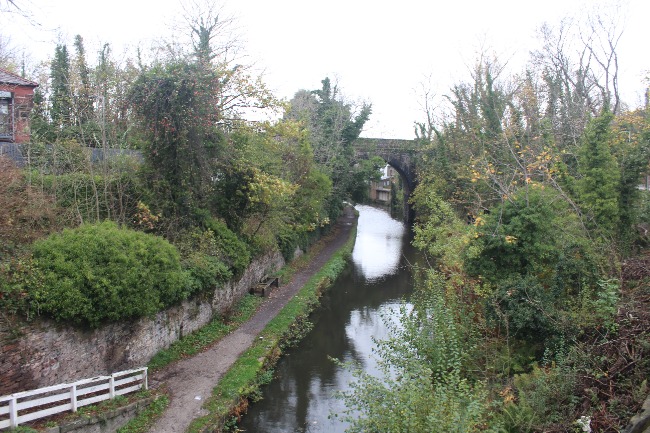
The path runs through Mersey Vale Nature Park, the park contains the remains of the top half of a scissors junction between the Midland and the Cheshire Lines Committee routes. The Midland came from south of the river crossing over the the river and the CLC, the north abutment of this viaduct can still be seen.

Below - North abutment of the line that carried the Midland route over the River Mersey and the CLC route.


Below - After passing under the Midland line the CLC also crossed over the River Mersey on a metal viaduct. The south abutment of this can be seen on the other side of the river.


South of the river the CLC line continued to Glazebrook Junction where it met the line through Warrington Central. Beyond the missing river bridge a section of the line remains in situ as far as the connection with the Altringham line near Timperley, it now accessed south of the river via the Midland's "Loop Line" that connects it with the route from New Mills. Further east, to the north of Gatley, it is joined by the passenger line to Altringham and Chester via Stockport.
The rest of today's walk is along Midland lines rather than CLC lines. Firstly heading up to the top of the abutment of the Midland bridge there is a footpath along the former line.

Below - East of Vale Road looking back towards the bridge over the CLC and the Mersey, the site of Heaton Mersey Station Junction can be seen. There is a less well defined path along the north side of the triangle to Heaton Mersey East Junction, I also followed this path though it is quite overgrown. 


Heaton Mersey


The bridge over Vale Road has been removed and the path descends to road level. Around the site of Heaton Mersey station the embankment has been levelled and built on with a row of retail units. I followed Station Road on to Green Pastures. From there a cycle path, National Cycle Network route 55, follows the former railway route although the cutting has been partially filled in.

Below - The bridge under Parrs Wood Lane / Didsbury Road.


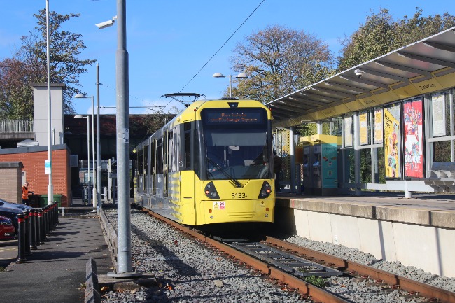
Below - Between Parrs Wood Lane / Didsbury Road and the bridge under the LNWR line is now the East Didsbury terminus of the Manchester Metrolink. From here to the former Manchester Central station is now a Metrolink tram route.


 From here I continued to the nearby East Didsbury station for a mainline train home.

Saturday 12 November 2022

Cheshire Lines Committee: Godley - Tiviot Dale

Starting Point - Godley station. Finishing Point - Brinnington station. Distance 10.1 Miles


Above - Tiviot Dale station in Stockport (picture from Wikipedia)

Manchester once had a couple of orbital railway routes south of the city centre primarily used by freight trains to avoid the busy commuter lines through the city centre stations. Had these routes remained open we would have avoided the recent chaos caused to railway timetables by unachievable numbers of passenger services sharing two tracks with freight for the busy Trafford Park container terminals through the "Castlefield Corridor."
Part of the orbital routes have been revived as Metrolink tram routes and much of the former trackbeds survive as footpaths.
I started at Godley where the route through Stockport Tiviot Dale left the line from Glossop and Hadfield.
The line to Hadfield is of course a stump of the former Woodhead Route that continued to Sheffield as well as freight branches into the coal mining areas of Yorkshire. It was coal traffic from Yorkshire to Fiddler's Ferry power station near Warrington that provided much of the traffic in later years. The first stretch of the route I walk from here to Woodley closed along with the Woodhead route in 1981.


Godley Junction

1935 Map (top left of map)

Godley station is now situated to the north of the original Godley Junction station. From the current station it is easy to find the original station, just across the road near the station entrance is Station Road.
The current station opened in 1986 on the site of the short lived Godley Toll Bar station that closed in 1842 when the line was extended. Godley Junction was renamed Godley East when the current Godley station opened and it carried on with a token service until closed in 1995.

Below - The former station entrance. Peering over the walls the platforms are still in situ together with fittings such as lamp posts.


According to Google Maps the foot and cycle path along the railway starts at the junction, however I found a fence across what had been the access to the branchline platforms. I accessed the former track from Brookfold Lane up a set of steps on the right hand side of the road leading to the same footpath shown on the old map above. The old railway wire fence separating the trackbed from the footpath survived but was easy to get across. Once on the former railway I doubled back towards Godley Junction station up to where I had found part of the station site fenced off.

Below - The former platform at Godley Junction for trains coming off the branch line. The branch line only ever had a very limited service of a morning and evening train.


Below - A part of an electrification gantry. The Woodhead Line that the route met was electrified, the electrification continued on to the branch a short distance, sidings and locomotive servicing facilities were provided for the electric locos to be swapped for steam locos. 


Below - The bridge over Brookfold Lane (where I joined the footpath on the left of the picture). Note how the bridge has been widened with a metal span to expand the sidings here.


Below - Steam locos arriving with trains from the west would need to be turned when their trains were taken over by electric traction before heading back with another service. The pit of the turntable survives and has been cleared as an interesting feature of the cycle route.


Below - An information board has been provided at the turntable.

Below - The turntable pit and one of the yard lamps.


Below - Loco inspection pits.

1935 Map

Below - What looks to be a coaling stage.


Below - Green Lane bridge, this seems to have had an extra arch constructed in association with the sidings for exchanging locomotives with the electrification of the Woodhead route.

Below - Grange Road bridge.

Below - The bridge between Mansfield Road and Hartshead View.


Below - Cutting and bridge for Stockport Road.

Below - Sign at the side of the cycle route.

Below - Bridge under Dowson Road.


Below - Bridge under Knott Fold.


Below - Bridge under Apethorn Lane. This is the end of the foot and cycle path as the trackbed continues up to the former connection with the surviving route through Woodley. The gate is an access point for maintenance staff to the surviving line.


Woodley


I continued along Hyde Road to Woodley station. Here a short stretch of the orbital route survives to serve a stone terminal an a household waste terminal at Bredbury.

Below - Looking south at Woodley station the freight branch can be seen on the right.


Below - The line crosses Woodley on a viaduct, passing over Hyde Road, the canal and a couple of other roads.


Below - The railway passing over the canal.


Below - At the back of the shopping centre in Woodley the former Mill Lane bridge is now a foot bridge over the freight line.


Hyde Road becomes Stockport Road. Passing Bredbury station, there was once a chord to the west of the station that connected to the orbital line, crossing under the road in a cutting just west of where the surviving line crosses over the road on a bridge. The cutting has been filled in and Carriage Road built on the course of the chord.
Beyond the end of the surviving section of freight line a Morrisons supermarket has been built on the course of the railway. Just past the supermarket I turned left on to the A560 (Ashton Road on the old map). On the west side of the road the bridge parapet survives where on the east side of the road it has been demolished and filled in to construct The Broadway, the entrance to the shopping complex.

Below - The west parapet of the former Ashton Road bridge.


A short stretch of trackbed could be seen at the foot of the bridge but this is fenced off and soon severed by the M60. To access the trackbed at the other side I used the footpath that goes around the Bredbury Interchange and through fields to Essex Road. From Brindale Road a footpath joins the railway trackbed west of the motorway.

Below - The former railway passes under Brinnington Road in a tunnel which is still open to the footpath.


Below - West of the tunnel was a second shorter tunnel which has since been opened up.


Stockport Portwood

The path emerges on to Bailey Road which serves an industrial estate built on the site of the former Portwood sidings. In what is now Tesco's car park was Portwood goods shed. This was also the site of a short lived passenger station from 1863 until 1875. After the more conveniently situated Stockport Tiviot Dale station opened to the west of Portwood in 1865 (I'll come to this shortly) Portwood was relegated to a goods shed, ideally placed to serve the local mills including the Meadow Mill which survives to this day and was being refurbished at the time of my visit.

Below - Outside Tesco's car park is a former water turbine from Portwood Mill on display in a small shelter.


Stockport Tiviot Dale

From the south side of Tesco's car park a footpath runs alongside the wall of the motorway, following the course of the railway. There was a bridge across the River Tame just before it meets the Mersey but this has been removed, though the abutment on the west side of the river can be seen.

Below - Abutment of the bridge over the River Tame. At the top of this bridge was Tiviot Dale station, a fairly substantial station with four platforms.


Heading north from the site of the Tame bridge a footpath runs to Penny Lane which emerges on to Lancashire Hill. The site of the station is overgrown, and it seems homeless people camp here. The top of the bridge of Lancashire Hill can be seen, here the railway went in to a tunnel which has been filled in. The site of the station buildings is now a small park off Lancashire Hill. A bit of platform edge can be seen in the overgrowth.
The station closed in 1967 when passenger traffic was diverted from Manchester Central to Manchester Piccadilly. The line remained open to freight traffic until 1980, however the construction of the motorway alongside caused damage to the tunnel immediately beyond Tiviot Dale station and was formerly closed in 1982, by which time the Woodhead route and its link through Godley Junction which brought much of the freight traffic to the route had gone anyway.

More about the former station can be found on the Disused Stations website. It was also covered in a Martin Zero video, including a scramble through the filled in tunnel. 

The following day I picked up the route the other side of the tunnel and continued to East Didsbury tram stop from where the Metrolink system has taken over the trackbed towards Manchester Central. Meanwhile on this walk I doubled back towards the Brinnington Tunnels to walk the link to the Midland and Great Central joint line through Reddish Vale, the Portwood & Brinnington Branch.


The branch closed in 1967 along with Tiviot Dale station but is now a path within Reddish Vale country park. The trackbed is situated either in cutting or a ledge in the hillside, though there are no bridges or other buildings on this stretch.

Below - Looking along the trackbed through the country park.


Below - Just before the site of Reddish Junction the path veers off to the left. The trackbed leads up to a gate at the site of the junction where it meets the surviving line through Reddish North.


I followed the path down to the lake and the visitor centre. More information on the country park can be found on their website. Crossing the park is the viaduct of the surviving line. After a tea break at the visitor centre I walked back to the trackbed and across to Brinnington station to the east of the park.

Below - The surviving line crossing the Reddish Vale Country Park on a viduct.