BROWSE JOURNEYS BY MAP VIEW

Saturday, 25 June 2022

Dublin Railway Stations


An explore of old railway stations around Dublin using the Luas tram network

Dublin once had a few more terminus stations than it does today. Rather than walking on this old railway explore though I was able to let the tram do most of the work as there are now tram stops at the former stations. There is a handy day ticket available from the ticket machines on the Luas network, ideal for a bit of an explore.

Below -  Railway Clearing House map from Wikipedia 


Dublin Tram and Train Map

Rail Map Online view

Dublin's surviving stations are interesting as they are largely as they were built in the Victorian era where as most major UK stations of that era were extensively rebuilt for later expansion. It was for this reason that Dublin Heuston was chosen to portray 1850s London Bridge in the Sean Connery film The First Great Train Robbery.

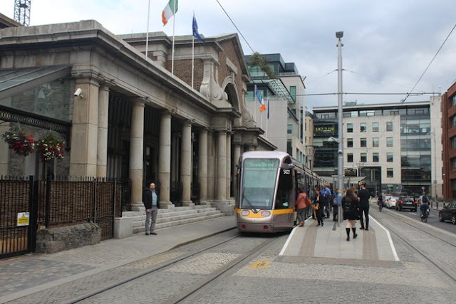
Dublin Heuston

Dublin Heuston opened in 1846 as Dublin Kingsbridge station, named after the nearby bridge over the River Liffey.  It was renamed in 1966 after Sean Heuston who was executed after the 1916 Easter Rising. The office block on the station front to this day contains the head offices of Ireland's railway company CIE.
More information can be found about the station on the Wikipedia page.

Below - Luas Red Line tram crossing the Liffey in front of Heuston station.


Below - The administration block in front of Heuston station.


Below - A loco hauled train for Cork under the station roof.


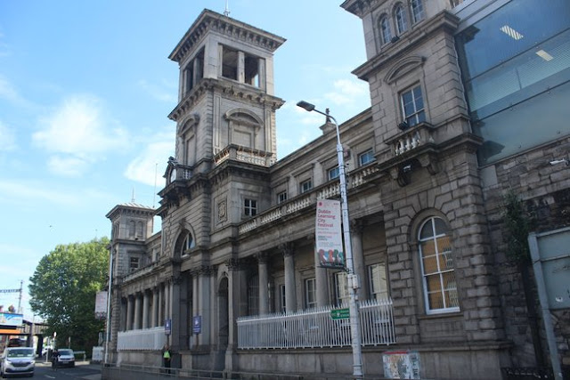
Dublin Connelly

Originally opened in 1844 as Dublin Station it was renamed Dublin Amiens Street in 1854. The original station was the four bay platforms. The through platforms were added in 1891 as the then separate Amiens Street Junction station. The through platforms linked the station to the former Westland Row terminus, now Dublin Pearse. Amiens Street station was renamed in 1966 after James Connolly who was executed following the Easter Rising in 1916. Though most passengers enter through the modernised entrance that incorporates the tram stop at the south of the station site the original facade on Amiens Street survives. More information can be found about the station on the Wikipedia page.

Below - The facade on Amiens Street.


Dublin North Wall

Taking the Luas Red Line tram to Spencer Dock it's a short walk to North Wall Quay. The ferries to and from Holyhead and Liverpool now dock much further out on the deeper water at the mouth of the Liffey, however they used to dock much closer to the city. England's London and North Western Railway built a terminus at North Wall for trains connecting with ferries to and from England. Though this station closed in 1922 most of the buildings are still in place.
More information can be found about the station on the Wikipedia page.

Below - Plan of North Wall station from Wikipedia.


Below - The former L&NWR North Wall station facade.


Below - The former Station Hotel


Below - The former goods warehouse adjoining the station.


Dublin Docklands

Not far north of the former North Wall station a new station was opened on the site of former goods sidings in 2007 to serve the regenerated Docklands area. At the time of writing services operate to M3 Parkway station on the closed Navan line, the intention is to reopen the line to Navan. Interchange with routes from Connolly station can be made at Broombridge, though Connolly is a short walk from Docklands.
More information can be found about the station on the Wikipedia page.

Below - Docklands station.


Broombridge is at the site of the former Liffey Junction station between the Midland Great Western Railway's passenger line to its Broadstone station and its goods line to the docks (now used by passenger trains to reach Connolly or Docklands stations.) The railway trackbed is now used by the Luas Green Line. At the site of Broadstone station the tram line runs alongside the former station site before curving on to the roads at the front of the station with Broadstone DIT tram stop alongside the former station entrance.

Dublin Broadstone

The station opened in 1847 and closed in 1937 with services diverted to the more centrally located stations. It remained in use until 1961 as a loco depot. The station site is now occupied by Bus Eireann with th office block that housed the MGWR head offices now serving as the bus company's head quarters. CIE proposed reopening the station in 2007 but with the tram proposals also on the table the new Docklands station was chosen instead.
More information can be found about the station on the Wikipedia page.

Below - A Luas Green Line tram stops at Broadstone DIT station beneath the office block of the original terminus.


Below - Adjacent to the station site which now forms Bus Eireann's depot and offices, former goods shed buildings are now used as another bus depot for the local Dublin Bus operations.


Below - The office block on the former Broadstone terminus. The entrance was just for the offices, passengers accessed via a collonade on the east side (right)


From Broadstone the Luas Green Line tram runs through the streets to Harcourt Street. This was once the site of a terminus station of a line to Bray. Again the tram stop is located on the road in front of the former station building.

Dublin Harcourt Street 

There were two routes from Dublin to Bray, the coastal route that survives to this day and a more inland route to Harcourt Street. The trackbed of the inland route is now part of the Luas Green Line from Charlemont station on the River Liffey just south of the former Harcourt Street station to Carrickmines. The tram continues to Brides Glen close to the original rail route. Brides Glen is not far north of Shankill where the line met the coastal route to Bray. The former Harcourt Street station survives in use as bars and restaurants.
More information can be found about the station on the Wikipedia page.

Below - Facade of the former Harcourt Street station.


Below - Luas Green Line tram at the stop next to the former station.


At the back of the station site it can be seen in the gap between the former station and adjacent offices that the station is on an the arches of a viaduct.
The remainder of the Luas day ticket was then used for finding food and drink and returning to the accommodation.


Saturday, 18 June 2022

Barry Pier & Breakwater

A short circular walk from Barry Island station to the former Barry Pier station

Barry Island's railway station is these days on a short branch line from Barry's main station on the Vale of Glamorgan line. At one time the line continued through a short tunnel and on to a pier from which passengers could board ferries across the Bristol Channel. 

Below - 1908 Photo of Barry Pier station with steamers alongside from Wikipedia.


Barry Island station is a short walk to the beach around the edge of the Barry Island Pleasure Park, a remnant of a vast Butlin's park that once stood here. It is said that Billy Butlin was inspired to build his empire of holiday camps by a disappointing childhood holiday where his family were locked out of a B&B in Barry Island during the day. The current Pleasure Park features a range of fairground rides just as the area did in its days as part of the Butlins site.
I walked along the promenade and on to the Clement Colley Walk footpath that follows the headland of Nell's point, this was previously covered with the chalets of the former Butlins camp, though this part of the site has been redeveloped with housing and a car park. 

Below - A view along the promenade. At either end are matching pavilion, the one at the furthest end has cafes and amusements with the nearest one being empty.


Below - Nell's Point Coastguard Station, a later replacement for the one shown on the old map.


Below - Around the headland the breakwater that protects the dock entrance can be seen.


In Jackson's Bay is a quite secluded beach that only seems to be used by local dog walkers. From the beach the path continues to the Jackson's Bay Lifesaving Club and up to Redbrink Crescent on the path shown on the old map.
I took a closer look at the breakwater, though there is a gate across the land end there is a well trodden path around this across the rocks and the breakwater appears to be a popular fishing spot. The track of the breakwater railway is still in place. 

Below - A look though the gates at the land end of the breakwater.


The old maps seem to show three rails, at first I thought this might have been a dual gauge line as cranes commonly used a wider gauge. Further reading revealed that there were two lines on different levels but the breakwater seems to have been built up to the one level. There is only evidence of one standard gauge track now.

Below - A shot of the breakwater railway and the lighthouse at the entrance to Barry Docks. The east breakwater can also be seen, this also had a railway running along it.


More information from an earlier explore of the breakwater site can be found on the Urban75 website which also has more archive photos of the breakwater and pier including one where a steam crane can be seen on the track. The rail mounted wooden hut previously seen is no longer there. I had wondered if this used the chassis of the rail mounted crane previously used on the breakwater.

Below - From the breakwater the pier can be seen. The pier and the site of the former station on it are now used by a yacht club. The hydraulic lift at the land end of the pier can still be seen.


Returning to the land end of the breakwater I followed the path up to Redbrink Crescent as the land of the former station site now owned by the yacht club is fenced off. I followed the roads round to Dock Road to access the other side of the fenced off site of the pier station site. A footpath is shown following the cliff edge just west of Dock Road however this is fenced off, possibly due to falling rocks. 
Along Dock Road the former Commercial Graving Dock can be seen through the fence, along with the railway lines alongside it. Returning to the site of Barry Pier station, that side is also fenced off. Behind the yachts stored there the top of the tunnel portal can just be seen. The rail connection to the line on the breakwater was by means of temporary rails which would be laid across the tracks in to Barry Pier station when it was required to move something on or off the breakwater. This is mentioned on the above Urban75 page along with a photo of the tunnel mouth in front of which the sleepers for the removal track can be seen. A short tunnel through Redbrink Point emerged at the siding at the back of the pump house next to the graving dock. The tunnel through Redbrink Point is still there but with the path following the foot of the cliffs fenced off this also couldn't be seen.
I returned along Dock Road to Plymouth Road. Between Barry Island station and the tunnel entrance a couple of goods sidings can be seen on the old map, these are currently part of the Barry Tourist Railway and with their main shed alongside Barry station set to be used by Transport for Wales for maintaining their new trains at the time of writing the shed on Plymouth Road looks set to become the main depot for the heritage operation. The shed on Plymouth Road is not shown on the 1920 map and is in fact of fairly modern construction. In the 1960s the yard was used to service diesel units and at that time it just had simple canopies over the fuelling points. Around the entrance to the yard typical GWR palisade iron fencing can still be seen.


 Below - Looking towards Barry Pier from the footbridge across Barry Island station. The disused sections of the once much longer platforms of Barry Island station can be seen.  It can be seen how the trackbed descended towards the tunnel which is just out of view. A tarmac roadway now occupies the former track to the tunnel which is now used as a shooting range. It has also been used as a filming location for Doctor Who in recent years.


Below - Barry Island station looking towards Barry with the truncated platform handling 4 coach trains at most now. The platform on the right belongs to the tourist railway but is currently used to stable stored coal wagons.


Saturday, 11 June 2022

Horwich Works

Starting Point - Horwich Parkway station. Finishing Point - Blackrod station. Distance 2.9 Miles

Horwich Works opened in 1887 replacing an earlier facility at Miles Platting near Manchester as the main engineering facility of the Lancashire and Yorkshire Railway. It continued as an important engine works under the London Midland and Scottish Railway and British Railways. The last steam locomotive was built at Horwich in 1957. In 1964 locomotive maintenance was moved to other sites and the Horwich works concentrated on carriage maintenance and container wagons until the works was closed in 1983. In true 1980s fashion the once vast engineering site became the Horwich Enterprise Park, an industrial estate of several smaller units in the former buildings. Many of the buildings became increasingly run down over the years and in more recent years most have been demolished for redevelopment as housing More information about the works can be found in the Wikipedia article
I visited the site in 2019 as some of the remaining buildings were about to be pulled down to make way for a link road for the new housing. Only a few of the works buildings around the north end of the site are to remain including the former office building, now named Rivington House. This last remnants of the works being designated a conservation area.


We started at Horwich Parkway station and walked past the modern retail and residential developments to reach Chorley New Road, heading north towards Rivington House. Along Chorley New Road were the older terraced houses that would once have housed the workers from the engine works. The streets are all named after key figures in steam engine manufacture. In one gap in the old housing on the north side of the street the modern Aspinall Court occupies the site of the Mechanics' Institute that once stood at the centre of the works' community.
Turning left for Rivington House this was once the main entrance gate for the works.

Below - Rivington House, once the offices for the Horwich Works.


Below - On the south end of the complex that included the office building was once the stores.

Below - Looking along the former stores building some of the railway lines can be seen in the concrete. Behind can be seen remnants of the by now much truncated erecting shops that still stood at the time.


Below - Another look at the stores building.


Below - A closer look at the railway tracks, note the narrow gauge track, this was part of the extensive 18 inch gauge internal railway system used to move material around the works site.


Below - Late 1970s map of the works complex from the Graces Guide website.


Below - The building shown on the above map as the Millwrights Shop and Pattern and Joiners Shop


The Gap between the various shops that once had the railway lines that connected the various parts of the site.


Below - The north end of the rows of buildings that once stretched for nearly half a mile. Another similar building once stood on the right of the picture.


Below - Shown on the above map as the Carriage Repair Shop and the Container Paint Shop.


In the above picture a security cabin can be seen, at this point I got chased away by security staff even though this is a view from a public road and similar was readily available just by looking on Google Streetview, in fact Streetview still showed many of the buildings that had already been demolished. The above buildings have themselves since been demolished too.

Having seen all we could of the remains of Horwich Works anyway we continued to Blackrod station for a train road. Station Road still crosses the overgrown trackbed of the branch line in to the works. The M61 also crosses over the former works branch on a bridge. In 1985 locomotive 47491 was named Horwich Enterprise at the works to publicise the future use of the site but with the sale of the complex from BREL to developers Parkfield Group in 1988 the rail connection was lifted in 1989.

Saturday, 4 June 2022

Royal Victoria Military Hospital

 Starting Point - Netley Station. Finishing Point - Royal Victoria Chapel. Distance - 1 Mile

The Royal Victoria Military Hospital was a huge complex near Southampton constructed in response to the Crimean war and criticism of the medical facilities provided for those wounded in Crimea. Though famously Florence Nightingale criticised it's design which was said to have put more thought in to providing a grand edifice than suitable facilities for treating patients. It came too late for soldiers serving in Crimea but would go on to treat casualties of the Boer War, First World War and Second World War. The main building of the hospital was 1/4 mile long and at the time the worlds longest building.
The hospital had a pier but it didn't reach deep enough water to be effective for transporting patients as they would have to be transferred from ships in to small boats to land at the pier, it ceased to be used for patient transfer in 1901. The pier was used for visits by Queen Victoria from  In 1900 a short branch was added from the nearby railway to take trains transporting patients in to the complex.
More about the hospital can be read on the Wikipedia page and the Netley Military Cemetery website

Below - A view of the hospital from the water. (Photo - Wikipedia)


The site of Netley station's goods yard has been redeveloped. One of the new roads, The Badgers, leads to a footpath that follows the former branch in to the hospital site. It curves away from the main line to the south before reaching Hound Road where it used to cross on a level crossing.
A small stretch of the trackbed is not a footpath, requiring a small two sides of a triangle detour on the nearby roads, picking the trackbed up where the path is shown on the modern Google Maps as the Hamble Rail Trail. It ran along a cutting and at the time of my visit was a bit overgrown and muddy but passable.
Another road is crossed and the path emerges in to the Royal Victoria Country Park that has been established on the hospital site and passes close to the park's cafe and site maintenance facility. These fine wooden buildings were originally a YMCA building added in 1940 to replace an earlier building nearby. More information about the building is given on part of the Hampshire County Council site.
A more thorough exploration of the former railway can be found on the Netley Military Cemetery website including more archive photos and a few bits of rail I missed.


The road that ran at the back of the original Victorian hospital buildings is still there and has rails from the rail connection still in place. The area is now used for car parking so some cars may be parked over the rails. A memorial with information boards marks the site of the station where patients were transferred to the hospital.

Below - Rails at the site of the railhead at the hospital. The point for the siding that ran in to a carriage shed alongside the road can be seen.


The use of the hospital declined after WW2, having played an important part in D Day. After the war it was last used to process Hungarian refugees in 1956 before closing in 1958. A large fire damaged much of the building in 1956 and most of the complex was demolished in 1966. Some of the buildings built in later years behind the main hospital building including a mental hospital that was established remained in use until 1978.
Of the original buildings only the hospital chapel remains. This includes the bell tower that once stood at the centre of the complex. The chapel now serves as a museum and tells the story of the hospital, it's staff and the patients it cared for.


On the land behind the original hospital buildings there is a miniature railway, the Royal Victoria Railway.