BROWSE JOURNEYS BY MAP VIEW

Saturday 26 February 2022

Dearne Valley Railway - Goldthorpe to Doncaster

Starting Point - Goldthorpe Station. Finishing Point - Potteric Carr Nature Reserve, Doncaster. 
Distance - 12.5 Miles.


Continuing my walk of the Dearne Valley Railway I got a train to Goldthorpe to pick it up where I finished on the previous walk from Crofton to Goldthorpe.


At Goldthorpe a stretch of the line had survived in to the 1990s to serve Goldthorpe Colliery using a chord that connected to the Leeds to Sheffield line.

Below - Video found on YouTube of the last coal train from Goldthorpe Colliery.


From Goldthorpe station I headed along Barnsley Road to the bridge over the DVR, this bridge survives though is filled in now. The cutting must have been very deep at this point as the Wath branch of the Hull and Barnsley Railway also crossed under Barnsley Road at the site of the B6098 junction before crossing over the DVR.

Below - Barnsley Road bridge.


A park is being established in the railway cuttings through Goldthorpe but at the time of my visit this was fenced off so I had to walk along the roads nearby.

Below - Straight Lane bridge. 


Below - Filled in High Street bridge.


Below - View west along the cutting from High Street bridge.


From Barnbrough Lane (now spelt Barnburg) the footpath that connected to Goldthorpe Colliery survives, now serving the houses built on the former colliery site. The metal footbridge seen in the 1990s video is still in use. From here the former trackbed itself is accessible. With the DVR ceasing to be a through route in 1966 loading facilities for the colliery were built where the through lines had once been. Some of the concrete foundations for these metal structures can still be seen.

Below - Remnants of Goldthorpe Colliery.


It was just east of the colliery, just before the Barnburg Lane bridge that the truncated line survived until the 1990s and this is evident from the surviving ballast. 

Below - Trackbed east of Goldthorpe Colliery with ballast still in situ.


Below - Barnburg Lane bridge.


Just east of the bridge a concrete lineside hut survives, this is around the site of the signalbox.

Below - Lineside hut.


Below - Green Lane bridge.


Another park occupies the site of Barnbrough Main Colliery, this is quite a recurring theme on this route.


Passing Harlington the cutting has been filled in but the path still follows the course of the railway. Hollowgate is crossed at road level, as is Church Lane. At Church Lane the metal girder of the burried bridge can be seen.

Below - Filled in and buried Church Lane bridge.


The site of Harlington Halt has been built on, a footpath from Church Lane connects to Crane Moor Close which joins Harlington Road (now Doncaster Road) where the railway would have crossed on a bridge. South of Doncaster Road the trackbed has been built on and a detour is necessary along Mill Lane to pick up the path along the River Dearne which joins the trackbed further south.


The bridge over Pastures Road has been removed and the path diverts to the road. The Denaby Ings Nature Reserve occupies the site of Denaby Halt, a building on the station site is accessed by a staircase where the steps up to the westbound platform would have been. At the back of the building there are bits of concrete and wood that may have been part of the steps for the eastbound platform and at ground level a brick gatepost can be seen. There are also a few stubs of upright sleepers in the ground that were probably for retaining the hard standing area for the grounded 4 wheel coach body that served as a waiting room.

Below - Site of Denaby station. At the bottom of the photo a concrete fence post can be seen, behind it is a length of old rail that looks to have been used as a gate post.


Below - Picture of one of the Railmotors at Denaby Halt in 1929 from the Conisborough and Denaby Main Heritage Group website.


Approaching Conisborough the landscape has changed considerably. The River Dearne has been diverted, presumably to prevent the flooding on the earlier maps. Clay pits and colliery spoil have also been landscaped over. After crossing an overflow from the ponds of the wetlands to the river (which looks like it could be an obstruction if water was overflowing) and passing through a wooded area I picked up the Transpennine Trail path. The railway ran alongside the path to the north and a footpath seems to follow the course of the railway. North of Kingswood Dearne Valley (in the former Earth Centre) a roadway was been built on the trackbed when Cadeby Main Colliery was still in use. Remains of the facilities for loading coal lorries can be seen amongst the fly tipped rubbish.

Below - Site of Cadeby Main Colliery.


Below - Sleepers at the site of Cadeby Main Colliery.


Below - Constitution Hill bridge.


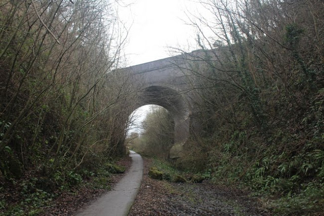
The DVR crossed over tunnels of the Hull and Barnsley Railway's Denaby Branch and the Swinton to Doncaster line which is still in use. On the north side of the roadway the H&BR tunnel mouth can be seen. I gather some have ventured in to the tunnel but it emerges in to a quarry site. The roadway heads towards the quarry but the course of the DVR is followed through the stone bollards and on to Conisborough Viaduct.

Below - Cadeby Tunnel on the former Hull and Barnsley Railway's Denaby Branch. 


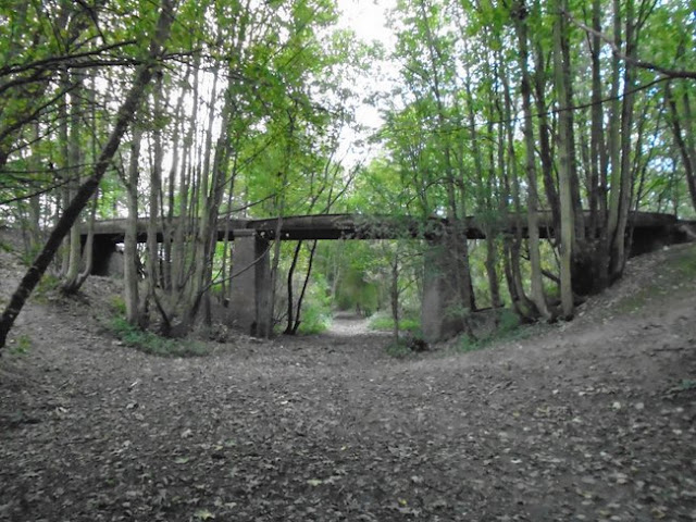
Below - Conisborough Viaduct.


Below - Doncaster Road bridge. Though this looks like a typical blue brick bridge over the railway at a distance up close it looks more modern, possibly the road has been widened in later years.


The cutting has been filled in but the footpath follows the course of the line up to where the Gowdall and Braithwell line crossed over on a bridge. Beyond there the DVR route is now in industrial use. The trackbed of the Gowdall and Braithwell line is now a road called Warmsworth Halt, I followed this to Edlington Lane. The only evidence that it was once a railway with sidings and a goods yard were the concrete fence posts on the north side of the road.


Heading south along Edlington Lane back to the course of the DVR, the site of Edlington Half is now occupied by the fire station. Edlington was the terminus of the passenger service from Wakefield. Described as "Edlington for Balby Doncaster" it can hardly be claimed to have served the latter. Of course this route was all about the coal, as evident from some of the most minimal stations ever seen.
Beyond the fire station the sports facilities that owe their existence to the nearby mines that were once here survive. A path leads through to the railway trackbed.

Below - Lord's Head Lane bridge.


At Broomhouse Lane the bridge has been removed. Certainly some people have climbed the embankment at the other side of the road, though it only continues as far as the A1M where there is no bridge over the motorway. I continued along Broomhouse Lane to Aldcliffe Cresent to pick up the path on the other side of the motorway. The sidings of Yorkshire Main Colliery were along Broomhouse Lane. This mine lasted until 1985 and a stub of the DVR east from here remained in use to serve it.
On the way to pick up the trackbed on the other side of the motorway I looked down Grange Lane where the bridge survives.

Below - Grange Lane bridge.


Below - Springwell Lane bridge.


A widened A60 with a roundabout junction has resulted in a stretch of cutting being filled in. One side of the filled in bridge can be seen.

Below - Filled in Balby Road bridge.


Below - Footpath bridge.


Below - Hall Balk Lane bridge.


Where White Rose Way has been built across the trackbed there is a walk around the road junctions to the entrance to Potteric Carr Nature Reserve. There is an entry fee to the reserve and a visitor center at the entrance has a cafe, shop and toilet facilities. The reserve has been established around Doncaster's railway version of Spaghetti Junction. The junction was redesigned in the 1970s to reuse the bridge that carried the South Yorkshire Joint Railway over the DVR for a new freight line to the sidings on the middle left of the old map. The access to the surviving section of DVR was from the chord shown on the old maps as No 10 section, heading south on to the South Yorkshire Joint Railway. The DVR up to Black Carr East Junction, where it met the still existing freight lines is one of the paths within the reserve. No 10 and No 11 section chords are also now footpaths. It his hard to visualise how the DVR reached the SYJR bridge that crossed over it. Originally the chord from the South Yorkshire Joint Railway to the sidings on the left of the old map (shown without track on the map) was on a much higher embankment. The footpath along the DVR crosses under the chord using the same bridge as the Mother Drain, originally this bridge would have been much higher and a separate bridge north of it would have carried the line over the DVR. The height of the chord was reduced to meet the later freight lines passing under the SYJR lines.

Below - Sign from Low Ellers Junction signal box in Potteric Carr Nature Reserve. Low Ellers Junction was situated north of the East Coast main line where another chord branched off the SYJR for trains heading towards Doncaster.


Below - Bridge that used to take the South Yorkshire Joint Line over the Dearne Valley Railway. Beneath the middle span is now occupied by freight lines towards Doncaster.


Below - Bridge that took the No 11 Section joint line over the Mother Drain.


From here I walked in to Doncaster for a train home, though this was a more complicated walk than some of the earlier detours off the trackbed as pedestrians don't seem to have been thought of when the retail parks in the area were planned. Google Maps also suggested I should walk on a busy road without pedestrian access. The journey in to Doncaster took about 45 minutes so it is probably better to check out bus connections from the nearby retail parks.


Saturday 19 February 2022

Dearne Valley Railway - Crofton to Goldthorpe

Starting Point - Sandal and Agbrigg station. Finishing Point - Goldthorpe Station. Distance - 14 Miles.


Above - An ex War Department loco hauls a coal train north through Grimethorpe Halt in 1951 shortly before passenger services ceased. The halt itself was just an area out of shot at the foot of the bridge the photo was taken from where passengers could board the single coach train. Photo by Ben Brooksbank from Wikimedia Commons.

The Dearne Valley Railway was built to serve several collieries and connect a number of lines in the area of the Dearne Valley between Wakefield and Doncaster. Though built by an independent company the line was operated by the Lancashire & Yorkshire Railway from its opening in 1902 and subsequently by the London Midland and Scottish Railway and British Railways. Though primarily built for coal traffic a passenger service was operated between 1912 and 1951 initially using a single coach steam railmotor and later using push pull trains. Most of the route closed in 1966 but remnants continued in use to serve Goldthorpe Colliery and Yorkshire Main Colliery. Some of the chords built to connect to other lines south of Doncaster remain in use as part of a flying junction to separate freight and passenger lines that was built after the DVR closed but used some of the surviving infastructure. This walk was done over two days, breaking the journey at Goldthorpe. More about the history can be read on the Wikipedia article.

Google Map. This unfortunately doesn't show directions to follow the course of the railway, I also used Open Street Map to check out the right of way status of the former trackbed.


The route began at Crofton West Junction to the south east of Wakefield. The nearest railway station in use today is Sandal and Agbrigg on the local services between Leeds and Sheffield or Doncaster. Looking at the old map above reveals a maze of railway lines and I begin the walk by walking the Sandal Curve which once linked the Great Northern Railway and Midland Railway, the path begins at the end of the station carpark. It leads to Oakenshaw Lane, just before the former junction with the Midland line.

Below - Former "Sandal Curve" chord from the former GNR at Sandal and Agbrigg to the Midland line.


Below - Bridge carrying the former Sandle Curve. the embankment of the Midland line can be seen under the bridge, now just used as a single track freight branch to a glass works at Monk Bretton.


Below - Bridge carrying the former Midland line to Sheffield over the GNR.


Walton Colliery Nature Park has been established on the site of Sharlston West Colliery. I followed paths through the nature reserve to the northern edge of the park where a footpath can be seen crossing under the LNER's Crofton Branch from Oakenshaw Beck on the old map.

Below - Henry Daley Memorial dedicated to a local councillor.


The footpath had originally continued under Crofton West Junction but I found it to be fenced off, even though still shown as a footpath on Open Street Maps.

Below - Fenced off footpath bridge under the site of Crofton West Junction and the surviving Wakefield to Knottingley line.

There was a well trodden path up the embankment of the former Dearne Valley line that I followed, though somewhat weary about where it emerged in relation to the active railway. This is not shown as a footpath so it would probably be more sensible to pick up the trackbed at the site of Crofton South Junction at Shay Lane if planning on visiting the route.

Below - Former sewage works access under Crofton East Fork.


Interestingly this bridge has had the embankment removed behind the abutments revealing interesting detail of the bridge's construction.


I emerged on the road from the sewage works and on to Shay Lane at the site of Crofton South Junction, which is now occupied by a caravan storage facility.


The large cutting that once contained Crofton Hall Sidings has now been filled in and now contains sports fields and a children's play area. A footpath runs through the site to Hare Park Lane where the bridge survives but the trackbed has been filled in up to the bridge deck.

Below - Filled in Hare Park Lane bridge


The bridge over the former Great Northern line has been removed, the abutments of it can still be seen from passing trains. This means there is a detour through the streets of Crofton to pick up the line again at Santingley Lane.

Below - Crofton Colliery memorial on the corner of Spring Lane and Santingley Lane.


Below - Santingley Lane bridge, from here a path occupies the trackbed.


Below - Filled in farm access bridge for Santingley Grange.


Below - Remains of what seems to have been the milepost shown on the old map.


The Dearne Valley line crossed over the Stairfoot & Nostell line, previously known as the Barnsley Coal Railway of the South Yorkshire Railway and later the Great Central Railway. I have previously done a walk of this route. The bridge has been removed and the path descends to the level of the Barnsley Coal Railway where it crosses the path along it before climbing back up the embankment. Bridges have also been removed over Back Lane and Swine Lane so while the embankment survives there is little engineering work of the line to be seen until Ryhil.


The cutting through Ryhill has been filled in, though the path follows the course of the route. There is also no sign of Cow Lane bridge. Between Cow Lane and Brier Lane the path detours around the east side of the trackbed. The cutting has been filled in at Brier Lane bridge too but the bridge can still be seen.

Below - Filled in Brier Lane bridge


Brier Lane once provided access to Ryhill Halt. The path that accessed the southbound platform is now the path that continues along the course of the railway. The entrance to the path down to the northbound platform has been sealed off with railway sleepers, perhaps this dates back to passenger services ending in 1951?


Below - Site of access to the northbound platform of Ryhill Halt.


When I say platform, the stations on the Dearne Valley Railway were in fact very primitive with at most a hard standing of railway sleepers rather than platforms, passengers had to use the steps on the railmotor or coaches to climb up in to the carriage.

Below - Trackbed at the site of Ryhill Halt looking north.


After Ryhill the path descends back to track level from the filled in cutting and a small wooded area known as Cawker Wood contains a couple of interesting remnants of the line.

Below - Former farm access bridge.


Next is the former Colliery tramway to New Monkton Colliery. In part the tramway pre-dated the railway and when the Dearne Valley Railway was built a simple bridge with three cast iron spans was built over the railway. The 1893 map shows the tramway previously running in to a tunnel.

Below - Former New Monkton Colliery tramway bridge.


A footpath follows the tramway to Church Lane, though unfortunately I found that the viaduct shown on the old map had been demolished. The viaduct would have also been built in the early 1900s when the tramway was extended over the new line.

Below - A fishplate seen in Cawker Wood.


Below - Kirkgate Lane bridge.


The path crosses Hemp Dyke on a small footbridge, here the Dearne Valley Railway crossed over the Hull and Barnsley Railway though the bridge has been removed and the embankments leading up to it removed. The path runs along the east side of the trackbed, though I did find the trackbed itself could be followed through the cutting and under Blacker Lane bridge.

Below - Blacker Lane bridge.


The vegetation was quite thick and I missed any trace there might have been of Shafton Junction where a chord linked the DVR with the H&BR in the Hull direction. Open Street Map showed the footpath ending at the roundabout with Brierley Road and Southgate at the site of the tunnel mouth. In reality I should probably have emerged on to one of the residential streets north of here. The approach to the tunnel was quite overgrown and the tunnel itself filled in, it was a very steep climb up to the road. There was evidence of the top of the brickwork of the tunnel mouth but I didn't get a photo of this as I was hanging on to trees to climb up to road level and didn't fancy a rapid descent back to track level.
The site of Holroyd Sidings is now occupied by a steelworks so I continued on the nearby roads to Engine Lane. Here a wall of the bridge could be seen. This was also the site of access to Grimethorpe Halt.

Below - Engine Lane bridge. The photo at the top of the article was taken from this bridge.


Around the site of the once extensive Grimethorpe Colliery the landscape has been obliterated. Several large industrial units now occupy land around the colliery site including the Symphony warehouse built along the DVR trackbed. A new road Park Spring Road runs parallel to the DVR trackbed on the north east side of the trackbed. Where the steel footbridge crosses Park Spring Road a road leads in to the wind farm built on the colliery site and this leads to the Chapel Lane Nature Walk from here the former trackbed can be accessed as it passes Great Houghton. From here the trackbed can be followed the rest of the way to Glasshoughton.


Crossing Rotherham Road the cutting has been filled in and the bridge removed so the path crosses the road on the level. On the east side of the road the path uses the former access road to the goods yard of Great Houghton Halt to return to the track level. Originally a set of steps from the road took passengers down to track level to join trains here. A set of gate posts of the former station entrance can be seen in the vegetation.

Below - Gate post at entrance to former Great Houghton Halt.


Below - Bridge over Billingley Lane.


Below - Bridge over Thurnscoe Dike.


At Thurnscoe Junction a chord connected the DVR to the Sheffield to Leeds line in the north direction. Where the footpath crosses under the lines just east of the junction the bridges have been removed but the abutments survive. 

Below - Remains of footpath bridges under Thurnscoe Junction.


The site of the triangular junction is now in industrial use and the path runs along the south west side of the trackbed, crossing under the A635 at the Nicholas Lane bridge. The path continues on the course of the former railway for a short stretch, emerging at a road alongside the surviving Goldthorpe station.
The Goldthorpe station in use today is a later addition, originally a station existed on the DVR line here, the road the path emerges on to being the former access to it. The station was known as Goldthorpe and Thurnscoe and again consisted of a simple sleeper built platform. The line continued over the site of the current station on a bridge. 
From Goldthorpe I caught a train home, returning another day to continue the walk along the Dearne Valley Railway to Doncaster.

 Part 2: Goldthorpe - Doncaster